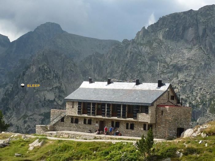
Mountain refuge Refugi de Quatrepins
We have it listed in the app!
We have it listed in the app!


If you are planning a route through refugi forestal de quatrepins, pista de llessui a espot, espot, pallars sobirá, lérida, cataluña, 25597, españa, the Refugi de Quatrepins refuge is a must-stop. Located at 2122 m above sea level, it offers hikers and climbers a safe place to regain strength. Save its coordinates (42.533, 1.084) in your GPS to stay on course during your journey.
6.6°C
Feels like: 4.1°C4.6 km/h
Gusts: 11.5 km/h4500 m
Snow lineUV 0
Clouds: 100% 10.6 mm
 17.5 km/h
 UV máx: 6.45
 06:19
06:19
 21:28
0 mm
16.8 km/h
UV máx: 8.05
06:19
21:29
0 mm
9.8 km/h
UV máx: 7.05
06:18
21:29
0 mm
7.9 km/h
UV máx: 7.4
06:18
21:30
0.6 mm
17 km/h
UV máx: 8.15
06:18
21:31
0 mm
9.7 km/h
UV máx: 4.8
06:18
21:31
0 mm
9.9 km/h
UV máx: 7.85
06:17
21:32
21:28
0 mm
16.8 km/h
UV máx: 8.05
06:19
21:29
0 mm
9.8 km/h
UV máx: 7.05
06:18
21:29
0 mm
7.9 km/h
UV máx: 7.4
06:18
21:30
0.6 mm
17 km/h
UV máx: 8.15
06:18
21:31
0 mm
9.7 km/h
UV máx: 4.8
06:18
21:31
0 mm
9.9 km/h
UV máx: 7.85
06:17
21:32
Here the mountain opens and exposes quickly. The Quatropins Refuge at 2122 m, it is located in the environment of Espot and works as a support in a strip where the ground can change in a short distance: high slopes, more open sectors and reliefs that link with nearby tops and cords as les Picardes , Muntanó , Pic de la Mainera or Pic de Peguera . This position places it in a useful area to read the day well from the map: to one side, references of valleys and accesses linked to Espot; to the other, more alpine terrain and link to hills and headers.
His interest depends not only on the exact point where he is, but on how he fits into the movement around this part of the Pyrenees. Very close they pass variants of the GR 11 especially the connection to the Refuge del Pla de la Font , and there also appear itineraries of greater journey as Foc Carros and its extended variant. This makes it a practical reference to divide stages, link itineraries or raise days in which the type of terrain and orientation conditions more than the pure distance. In an area like this, effort planning changes a lot if the route combines track, mountain path and more stony or higher sections.
The context of Espot and the proximity of the Peguera valley help to place it within a very mountainous area of the Sant Maurici area, where the reliefs gain height quickly and the transitions between forest, loma and mineral terrain are common. There is no need to understand it as an exclusive base for summits: it also makes sense as a free-of-way shelter for long journeys or tours between neighbouring valleys.
In terms of autonomy, it is appropriate to go out with margin. There's a very close source, Font Blanca , but in mountain the actual availability of water may vary by time and conditions. If a long day or link is proposed between routes, it is reasonable to confirm mapping, access status and meteorology before having this point as the only support.


📏 3.5 Km
⛰️ 2350 m

📏 4.2 Km
⛰️ 1879 m

📏 6.9 Km
⛰️ 2395 m

📏 7.2 Km
⛰️ 2015.8 m

📏 7.6 Km
⛰️ 2167 m

📏 7.9 Km
⛰️ 1885 m

📏 9 Km
⛰️ 2300m m
📏 10.7 Km
⛰️ 2380 m
Download the app and start looking for the shelter of your next adventure


Find a place to sleep before night falls.


