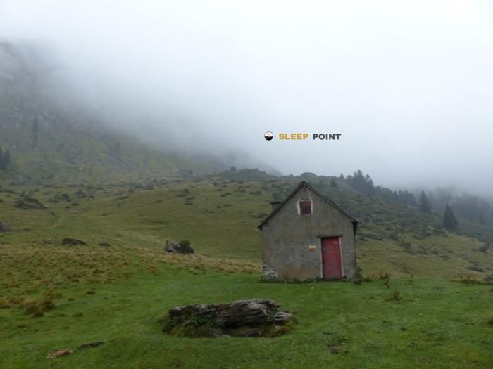
Mountain refuge Refuge Forestier ONF de la Fontaine de l'Isard
We have it listed in the app!
We have it listed in the app!


At 1400 meters above sea level, nestled in d 157, coustalats, saint-lary, saint-girons, ariège, occitania, francia metropolitana, 09800, francia, stands the Refuge Forestier ONF de la Fontaine de l'Isard refuge. It is the perfect stop to spend the night or catch your breath. GPS coordinates: 42.857, 0.881.
11°C
Feels like: 10.2°C2.6 km/h
Gusts: 6.5 km/h4460 m
Snow lineUV 0
Clouds: 77% 16.9 mm
 12.8 km/h
 UV máx: 4.5
 06:19
06:19
 21:30
0.2 mm
13 km/h
UV máx: 7.85
06:18
21:31
1.7 mm
12.4 km/h
UV máx: 6.85
06:18
21:31
0.4 mm
8.5 km/h
UV máx: 7.65
06:18
21:32
4.2 mm
8.3 km/h
UV máx: 7.45
06:18
21:33
2.4 mm
6.8 km/h
UV máx: 2.3
06:17
21:33
0 mm
8.2 km/h
UV máx: 7.7
06:17
21:34
21:30
0.2 mm
13 km/h
UV máx: 7.85
06:18
21:31
1.7 mm
12.4 km/h
UV máx: 6.85
06:18
21:31
0.4 mm
8.5 km/h
UV máx: 7.65
06:18
21:32
4.2 mm
8.3 km/h
UV máx: 7.45
06:18
21:33
2.4 mm
6.8 km/h
UV máx: 2.3
06:17
21:33
0 mm
8.2 km/h
UV máx: 7.7
06:17
21:34
In this sector of the Ariège, near Saint-Lary and the area of Coustalats, the Refuge Forestier ONF de la Fontaine de l'Isard It works more in support of passage and autonomy than as a shelter linked to immediate access from the urbanized valley. Its position, about 1400 meters away, places it in a mountain strip where the forest still weighs in the landscape, but it already serves as a transition to more open slopes, peaks and summits of the area of the Biros. It is also within a useful environment for those who link long routes, with the GR 10 and tours of the Val d'Aran relatively close.
The approach and continuity of the day depend much on the chosen orientation. In this part of the mountain, a change of side changes the terrain, the exhibition and the reading of the itinerary, something important if you consider using the free shelter as an intermediate stop or as a short base to move around nearby cords. In the environment, elevations such as Pic de l'Har , Pic de la Calabasse or Pic du Crabere which help to understand the mountainous character of the sector, although it is not appropriate to interpret its closeness in a straight line as a direct or simple ascension from the shelter.
In practice, the most useful data is the presence of a source at about 570 meters, sufficient to consider that water can be resolved near, but with the usual mountain prudence: state of flow, time of year and need to potentiate if appropriate. As in many free forest shelters, it is reasonable to arrive with basic autonomy and not to rely on finding specific conditions on the ground. For a journey, it fits well as a stage break point; for summit activity, it makes more sense as prior logistical support than as an advanced high mountain camp.


📏 0.5 Km
⛰️ 1500 m

📏 0.5 Km
⛰️ 1492 m

📏 0.5 Km
⛰️ 1660 m

📏 0.6 Km
⛰️ 1330 m

📏 1.3 Km
⛰️ 1485 m
📏 1.4 Km
⛰️ 1480 m

📏 2 Km
⛰️ 1760 m

📏 2.2 Km
⛰️ 1571 m
Download the app and start looking for the shelter of your next adventure


Find a place to sleep before night falls.


