Mountain refuge Refuge Elisabetta Soldini Montanaro

We have it listed in the app!


            Mountain refuge Refuge Elisabetta Soldini Montanaro in rifugio elisabetta soldini montanaro, scorciatoia, lex blanche, courmayeur, valle de aosta, italia
Five orange stars in a horizontal row representing a five-star rating.

Refuge Elisabetta Soldini Montanaro

Lat: 45.767xxx – Lon: 6.837xxx
📍 rifugio elisabetta soldini montanaro, scorciatoia, lex blanche, courmayeur, valle de aosta, italia
Refuge Elisabetta Soldini Montanaro

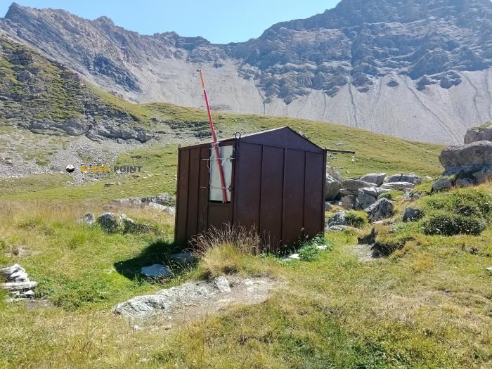
Protected by the wild surroundings of rifugio elisabetta soldini montanaro, scorciatoia, lex blanche, courmayeur, valle de aosta, italia, the Refuge Elisabetta Soldini Montanaro refuge is your best ally at 2195 meters of elevation. Once you reach its coordinates (45.767, 6.837), you can enjoy a well-deserved mountain rest.

See more
See more
Usuario

Lucas Martinez

Premium user

Live weather: Refuge Elisabetta Soldini Montanaro

The current weather in Refuge Elisabetta Soldini Montanaro indicates a temperature of 6.2°C, although the 8.9 km/h wind makes it feel like 2.4°C. Watch out for gusts of 18.4 km/h. The snow altitude (freezing level 0°) is around 4010 m and today we will reach a high of 10°C.
Temperature

6.2°C

Feels like: 2.4°C
Wind

8.9 km/h

Gusts: 18.4 km/h
Freezing level 0°

4010 m

Snow line
Sky & UV

UV 0

Clouds: 63%

Next 48 hours evolution

7-day forecast

04/06
10°
20.5 mm 21.7 km/h UV máx: 6.45
05:44 21:17
05/06
7.9° 0.8°
0.8 mm 19.3 km/h UV máx: 6.75
05:44 21:18
06/06
10.7°
0 mm 17.6 km/h UV máx: 8
05:43 21:18
07/06
13.8° 4.8°
0 mm 12.1 km/h UV máx: 8
05:43 21:19
08/06
14.4° 7.2°
1.05 mm 16.3 km/h UV máx: 7.1
05:43 21:20
09/06
10.3° 4.8°
10.8 mm 14.2 km/h UV máx: 6.3
05:42 21:20
10/06
14.1° 3.1°
0 mm 11.5 km/h UV máx: 7.8
05:42 21:21

In the valley of Veny, over Courmayeur

At 2,195 metres, the Refuge Elisabetta Soldini Montanaro is located at the head of the environment of Lex Blanche, in the high sector of Courmayeur, within the Aosta Valley and in the middle of the Mont Blanc massif. This position places it in a clearly alpine terrain, open and exposed to rapid time changes, where the orientation of the valley and the reading of the relief help as much as the signage itself.

For those who seek a free shelter or a basic reference of support in the journey, it is appropriate to start from a simple idea: here the important thing is autonomy. The altitude, relative isolation and lack of complete equipment data suggest margin planning, especially if it is reached with unstable meteorology or outside a very defined route. On the other hand, there is a very close source, about 25 metres, and another at a short distance, which gives a useful reference for water management, although in the mountain it is always appropriate to foresee seasonal variations.

Step reference and map

More than as a basis for concrete ascendations, this shelter fits well for hiking and mountaineers who are moving on link routes. Its location makes sense within the Tour du Mont Blanc in both the main itinerary and the variant of the Col des Fours, and also in the context of the Alta Via n. 2 della Valle d'Aosta . This makes it an easy point to place on a map to divide days or confirm position in an area where long-distance routes are combined with local tracks.

The immediate environment refers to a landscape of high glacier valley, with broad references to the massif and border summits such as the Aiguille des Glaciers, but without the need to present the place as a point of attack to specific peaks. Its role is more practical: to provide support in a mountain transit area, useful for those who prioritize road continuity, near water and a clear location within the southern sector of Mont Blanc.

Hiking routes from the refuge

14

Pont Combal - Bivacco Rainetto

↔ 3.737 km
Local

Tour Du Mont Blanc - Variante du Col des Fours

↔ Variable distance
TMB-IP

Tour du Mont Blanc - Itinéraire principal

↔ Variable distance
AV2

Alta Via n. 2 della Valle d'Aosta - Tappa 1

↔ 15.000 km
AV2

Alta Via n. 2 della Valle d'Aosta - Tappa 2

↔ 18.000 km
14

Strada Piccolo San Bernardo (parch.Lac Verney) - Lacs de la Pointe Rousse

↔ 6.443 km
13

Rifugio Elisabetta - Bivacco Hess

↔ Variable distance
13

Faubourg - Col d'Arp (Pré-Saint-Didier) Vallone di Youla

↔ 9.2 km

Nearby water fountains

Fuente

25 m
Lat: 0 Lon: 0

Fountain

171 m
Lat: 0 Lon: 0

Fountain

5.97 Km
Lat: 0 Lon: 0

Fuente

6.26 Km
Lat: 0 Lon: 0

Fuente

7.71 Km
Lat: 0 Lon: 0

Fuente

8.11 Km
Lat: 0 Lon: 0

Fuente

8.28 Km
Lat: 0 Lon: 0

Fuente

8.31 Km
Lat: 0 Lon: 0
FAQ

Frequently asked questions

Pregunta frecuente
In which municipality or region is the Refuge Elisabetta Soldini Montanaro refuge located?
This refuge is located within the municipality of Courmayeur, belonging to the community or region of Valle de Aosta.
Pregunta frecuente
Are there other mountain refuges near Refuge Elisabetta Soldini Montanaro?
Yes, nearby you can find other options to spend the night or take shelter. El refugio más próximo es el Bivouac d'Estelette (Adolfo Hess), que se encuentra a aproximadamente 1.6 km de distancia.
Pregunta frecuente
At what exact altitude is the Refuge Elisabetta Soldini Montanaro refuge located?
The Refuge Elisabetta Soldini Montanaro refuge is located at an altitude of 2195 meters above sea level, in the natural surroundings of rifugio elisabetta soldini montanaro, scorciatoia, lex blanche, courmayeur, valle de aosta, italia.
More areas

Other areas

Collaborative

Together we improve

image

Send your photos

You can upload photos of shelters and update their status so other users know if they can go there.

Get started
Get started
image

Rate the shelter

Leave your comments to rate the shelter’s condition. In the mountains, we look after each other.

Get started
Get started
image

Add new ones

Did we miss any? Publish the shelters you know so everyone can use them.

Get started
Get started
Download for free from the Apple App Store and Play Store.

Download the app and start looking for the shelter of your next adventure

Aplicación móvil para encontrar refugios de montaña donde dormir
Aplicación móvil para encontrar refugios de montaña donde dormir.
Mapa interactivo de refugios de montaña en los Pirineos dentro de la app
Mapa de refugios de montaña para senderismo y trekking en la app.
Pantalla con información de refugio de montaña con altitud capacidad y servicios
Pantalla con información de refugio de montaña con altitud capacidad y servicios.
Detalles de refugio de montaña con servicios y meteorología en aplicación móvil
Detalles de refugio de montaña con servicios y meteorología en aplicación móvil.
Aplicación para explorar refugios de montaña mediante mapa interactivo
Aplicación para explorar refugios de montaña mediante mapa interactivo.
Ficha completa de refugio de montaña con opiniones y servicios
Ficha completa de refugio de montaña con opiniones y servicios.
Información detallada de refugio en app para montañeros
Información detallada de refugio en app para montañeros.
Listado de refugios de montaña para senderismo y trekking
Listado de refugios de montaña para senderismo y trekking.
Explorar refugios de montaña desde una aplicación móvil
Explorar refugios de montaña desde una aplicación móvil.