Mountain refuge Refuge du Soplat des Nants

We have it listed in the app!


            Mountain refuge Refuge du Soplat des Nants in soplat des nants, chemin des cascades, tours-en-savoie, albertville, saboya, auvergne-rhône-alpes, francia metropolitana, 73790, francia
Five orange stars in a horizontal row representing a five-star rating.

Refuge du Soplat des Nants

Lat: 45.666xxx – Lon: 6.475xxx
📍 soplat des nants, chemin des cascades, tours-en-savoie, albertville, saboya, auvergne-rhône-alpes, francia metropolitana, 73790, francia
Refuge du Soplat des Nants

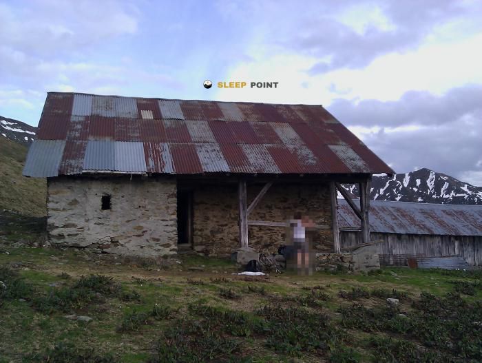
If you are planning a route through soplat des nants, chemin des cascades, tours-en-savoie, albertville, saboya, auvergne-rhône-alpes, francia metropolitana, 73790, francia, the Refuge du Soplat des Nants refuge is a must-stop. Located at 1425 m above sea level, it offers hikers and climbers a safe place to regain strength. Save its coordinates (45.666, 6.475) in your GPS to stay on course during your journey.

See more
See more
Usuario

Lucas Martinez

Premium user

Live weather: Refuge du Soplat des Nants

Before heading to Refuge du Soplat des Nants, check the weather: we currently have 9.5°C (feels like 7.5°C). With wind gusts reaching 12.6 km/h and a freezing level around 4010 meters, the daytime high will not exceed 12.9°C.
Temperature

9.5°C

Feels like: 7.5°C
Wind

4.4 km/h

Gusts: 12.6 km/h
Freezing level 0°

4010 m

Snow line
Sky & UV

UV 0

Clouds: 80%

Next 48 hours evolution

7-day forecast

04/06
12.9° 6.8°
31.3 mm 10.5 km/h UV máx: 4.65
05:46 21:18
05/06
10.3° 6.1°
2 mm 9.4 km/h UV máx: 6.25
05:46 21:19
06/06
16.6° 7.3°
0 mm 10.5 km/h UV máx: 7.55
05:45 21:19
07/06
17.4° 9.7°
0.5 mm 8.9 km/h UV máx: 7.35
05:45 21:20
08/06
19.1° 11.2°
1.8 mm 9.8 km/h UV máx: 6.95
05:45 21:21
09/06
13.7° 9.2°
14.1 mm 10.9 km/h UV máx: 6.15
05:44 21:21
10/06
17.8° 7.1°
0 mm 8.7 km/h UV máx: 7.4
05:44 21:22

Close summits and slopes

Under the Pointe de la Grande Journée and in the Mont Mirantin , this shelter is located 1,425 metres in Soplat des Nants, over Tours-en-Savoie, on the Albertville side and the Beaufortain massif. The reference of the forthcoming summits helps to understand its role: not so much a point of high extreme mountain, but an intermediate support on a mountain slope that connects forest, highways and accesses to more open reliefs.

Use in step or withdrawal

For its position, it can fit both as a stop on crossing routes and on a shorter day of rise and descent from low levels. The closeness of the Tour du Beaufortain and of its variant reinforces that function of a step-by-step shelter, useful for dividing a path or to resolve a withdrawal before losing too much height. It also remains within a network of local trails through forest areas, which links it to less alpine but continuous road routes.

Access runs in a context of half a moist and wooded mountain, where the orientation and state of the ground can influence more than the altitude itself. In this type of location it is appropriate to have room for rain, mud or changing visibility, and not to raise it as a coat with confirmed performance if the practical information has not been verified before.

For logistical purposes, there is a very close source, about 20 metres, a useful data for planning. However, in the mountains it is appropriate to check flow and conditions according to the time of the year. If it is used as a support to link the Beaufortain or as an escape point over the Turs-en-Savoie valley, the key is to maintain a prudent planning: water, meteorology and clear alternative of descent.

Hiking routes from the refuge

Local

Tour du Beaufortain

↔ Variable distance
Local

Tour du Beaufortain Variante

↔ Variable distance
Local

Promenons-nous... dans la forêt de Tal

↔ Variable distance
Local

Entre Grignon et Monthion

↔ Variable distance
Local

Randonnée en forêt sur les hauteurs de Grignon

↔ Variable distance
Local

Forêt de Rhonne

↔ Variable distance
Local

L'Oratoire

↔ Variable distance
Local

Forêt du Rhonne version courte

↔ Variable distance

Nearby peaks

Pointe de la Grande Journée

2460 m
Lat: 45.6676 Lon: 6.5009

La Roche-Pourrie

2041 m
Lat: 45.684 Lon: 6.4603

Légette du Mirantin

2353 m
Lat: 45.6872 Lon: 6.5119

Mont Mirantin

2463 m
Lat: 45.6842 Lon: 6.4991

Cote 2100

2100 m
Lat: 45.6844 Lon: 6.5195

Pointe de la Grande Combe

2175 m
Lat: 45.6507 Lon: 6.5233

Roche Plane

2166 m
Lat: 45.6941 Lon: 6.5193

Pointe du Dard

2489 m
Lat: 45.635 Lon: 6.524

Nearby water fountains

Fuente

19 m
Lat: 45.635 Lon: 6.524

Fuente

2.95 Km
Lat: 45.635 Lon: 6.524

Ruisseau du Soufflet

3.15 Km
Lat: 45.635 Lon: 6.524

Fuente

3.24 Km
Lat: 45.635 Lon: 6.524

Fuente

3.26 Km
Lat: 45.635 Lon: 6.524

Fuente

3.3 Km
Lat: 45.635 Lon: 6.524

Fuente

3.31 Km
Lat: 45.635 Lon: 6.524

Col des cyclos

3.58 Km
Lat: 45.635 Lon: 6.524
FAQ

Frequently asked questions

Pregunta frecuente
In which municipality or region is the Refuge du Soplat des Nants refuge located?
This refuge is located within the municipality of Tours-en-Savoie, belonging to the community or region of Auvergne-Rhône-Alpes.
Pregunta frecuente
Are there other mountain refuges near Refuge du Soplat des Nants?
Yes, nearby you can find other options to spend the night or take shelter. El refugio más próximo es el Chalet de l'Aulp de Tours, que se encuentra a aproximadamente 1.5 km de distancia.
Pregunta frecuente
At what exact altitude is the Refuge du Soplat des Nants refuge located?
The Refuge du Soplat des Nants refuge is located at an altitude of 1425 meters above sea level, in the natural surroundings of soplat des nants, chemin des cascades, tours-en-savoie, albertville, saboya, auvergne-rhône-alpes, francia metropolitana, 73790, francia.
More areas

Other areas

Collaborative

Together we improve

image

Send your photos

You can upload photos of shelters and update their status so other users know if they can go there.

Get started
Get started
image

Rate the shelter

Leave your comments to rate the shelter’s condition. In the mountains, we look after each other.

Get started
Get started
image

Add new ones

Did we miss any? Publish the shelters you know so everyone can use them.

Get started
Get started
Download for free from the Apple App Store and Play Store.

Download the app and start looking for the shelter of your next adventure

Aplicación móvil para encontrar refugios de montaña donde dormir
Aplicación móvil para encontrar refugios de montaña donde dormir.
Mapa interactivo de refugios de montaña en los Pirineos dentro de la app
Mapa de refugios de montaña para senderismo y trekking en la app.
Pantalla con información de refugio de montaña con altitud capacidad y servicios
Pantalla con información de refugio de montaña con altitud capacidad y servicios.
Detalles de refugio de montaña con servicios y meteorología en aplicación móvil
Detalles de refugio de montaña con servicios y meteorología en aplicación móvil.
Aplicación para explorar refugios de montaña mediante mapa interactivo
Aplicación para explorar refugios de montaña mediante mapa interactivo.
Ficha completa de refugio de montaña con opiniones y servicios
Ficha completa de refugio de montaña con opiniones y servicios.
Información detallada de refugio en app para montañeros
Información detallada de refugio en app para montañeros.
Listado de refugios de montaña para senderismo y trekking
Listado de refugios de montaña para senderismo y trekking.
Explorar refugios de montaña desde una aplicación móvil
Explorar refugios de montaña desde una aplicación móvil.