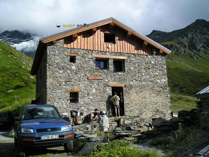
Mountain refuge Refuge du Ruitor
We have it listed in the app!
We have it listed in the app!


Conquering the trails of refuge du ruitor, v.t.t. route no. 9, sainte-foy-tarentaise, albertville, saboya, auvergne-rhône-alpes, francia metropolitana, 73640, francia is easier with the Refuge du Ruitor refuge. Located at 2038 m (coordinates 45.626, 6.941), it is the ideal shelter against harsh mountain weather.
6.6°C
Feels like: 2.8°C8.5 km/h
Gusts: 18 km/h3990 m
Snow lineUV 0
Clouds: 94% 25 mm
25 mm
 14.5 km/h
 UV máx: 6.2
 05:44
05:44
 21:16
1.2 mm
13.2 km/h
UV máx: 7.7
05:44
21:17
0 mm
24.8 km/h
UV máx: 7.75
05:44
21:17
0 mm
14 km/h
UV máx: 7.95
05:43
21:18
0.15 mm
16.1 km/h
UV máx: 7.75
05:43
21:19
2.1 mm
14.8 km/h
UV máx: 6.2
05:43
21:19
0.3 mm
9.8 km/h
UV máx: 7.75
05:42
21:20
21:16
1.2 mm
13.2 km/h
UV máx: 7.7
05:44
21:17
0 mm
24.8 km/h
UV máx: 7.75
05:44
21:17
0 mm
14 km/h
UV máx: 7.95
05:43
21:18
0.15 mm
16.1 km/h
UV máx: 7.75
05:43
21:19
2.1 mm
14.8 km/h
UV máx: 6.2
05:43
21:19
0.3 mm
9.8 km/h
UV máx: 7.75
05:42
21:20
Before proposing a stop here it is appropriate to check well water, weather and lace of the day. The Refuge du Ruitor , in the surroundings of Sainte-Foy-Tarentaise, it works mainly as a mountain shelter in a sector of passage where several traverses can make a deviation worth it or not according to the route taken. Its position, at 2038 meters, already places it in an exposed environment, with changing conditions and a reading of the land more typical of open mountain than of the valley bottom. In this area of Savoy, near the axis of the Petit-Saint-Bernard and the links to the valdostana side, the shelter fits better as support to divide stages or adjust efforts than as a simple isolated destination.
The practical utility is understood when looking at the map: they pass through the travel routes sector as the Via Alpina and Grand Tour de Tarentaise , so it can serve as an intermediate point if you are looking to split down or gain margin in the face of a change of time. There is no data here on forthcoming summits, so it should be read more as logistical support than as a clear basis for ascension. With regard to water, sources appear at about 1.68 and 1.7 km, a distance sufficient not to resolve the supply without planning. If you are late, with fog or with unstable foresight, you want to go out with autonomy and not depend on finding immediate resources in the environment.


📏 2.9 Km
⛰️ 2557 m
📏 2.9 Km
⛰️ 2030 m

📏 6.2 Km
⛰️ 3357 m

📏 6.5 Km
⛰️ 2494 m

📏 6.9 Km
⛰️ 2916 m

📏 7.2 Km
⛰️ 2155 m

📏 9.3 Km
⛰️ 2975 m

📏 10.1 Km
⛰️ 2370 m
Download the app and start looking for the shelter of your next adventure


Find a place to sleep before night falls.


