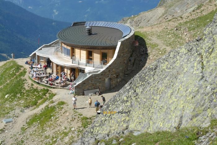
Mountain refuge Refuge du Fioux
We have it listed in the app!
We have it listed in the app!


Discover the Refuge du Fioux refuge, an alpine shelter located at 1505 meters in the area of refuge du fioux, 4409, route de bionnassay, le crozat, saint-gervais-les-bains, bonneville, alta saboya, auvergne-rhône-alpes, francia metropolitana, 74170, francia. Whether you are on a multi-day trek or a day hike, this point (45.872, 6.761) will provide the peace and shelter you seek in the mountains.
7.9°C
Feels like: 6.4°C1.6 km/h
Gusts: 5 km/h4000 m
Snow lineUV 0
Clouds: 94% 25.9 mm
 12.3 km/h
 UV máx: 6.2
 05:44
05:44
 21:18
1.1 mm
10.2 km/h
UV máx: 6.6
05:44
21:18
0 mm
9.4 km/h
UV máx: 7.75
05:43
21:19
0 mm
8.4 km/h
UV máx: 7.7
05:43
21:20
0.9 mm
9 km/h
UV máx: 6.75
05:43
21:21
8.1 mm
10 km/h
UV máx: 4.85
05:42
21:21
0 mm
8.7 km/h
UV máx: 7.6
05:42
21:22
21:18
1.1 mm
10.2 km/h
UV máx: 6.6
05:44
21:18
0 mm
9.4 km/h
UV máx: 7.75
05:43
21:19
0 mm
8.4 km/h
UV máx: 7.7
05:43
21:20
0.9 mm
9 km/h
UV máx: 6.75
05:43
21:21
8.1 mm
10 km/h
UV máx: 4.85
05:42
21:21
0 mm
8.7 km/h
UV máx: 7.6
05:42
21:22
On the slope of Bionnassay , within the term of Saint-Gervais-les-Bains, the Refuge du Fioux appears at 1.505 meters in intermediate support between forest and grass and the itineraries that gain height towards the cords of the area. This position places it in a transitional terrain: it is not at the bottom of the valley or in a fully glacial environment, but it is in a strip where the orientation of the route and the changes of exposure begin to have a great influence on the progression, especially when the paths are linked to the more open slopes, hills and slopes.
A number of road connections are well understood from here. The step towards Tricot Col and the variant of Tour du Mont Blanc make it a useful reference to plan a stage or divide a day, while itineraries to Aiguille Croche , Le Bettex - Arbois or the Chalet des Pyramides extend the radius of movement on the immediate mountain. It also helps to read the near relief: peaks such as Mont Vorassay, Mont Lachat, Le Prarion or Bellevue mark orientation and slope changes that can be translated into more sunny sections, wet areas or steps more exposed to the wind according to the chosen side.
In terms of logistics, one of the most useful data is the presence of water very close to the shelter, with a source located just a few meters and several more within a short radius. However, in mountain it is appropriate not to take for granted its availability at any time and to adjust the autonomy of water to the time and to the intended route. As no internal equipment or conditions are detailed here, planning should be done with a conservative approach: a reliable map or track, room for weather changes and material corresponding to an area where a simple change of slope can change the terrain and the pace of progress.


📏 0.8 Km
⛰️ 1320 m

📏 3.2 Km
⛰️ 1757 m
📏 3.5 Km
⛰️ 2372 m

📏 3.7 Km
⛰️ 1560 m

📏 4.1 Km
⛰️ 1720 m

📏 4.8 Km
⛰️ 3167 m

📏 5.2 Km
⛰️ 2730 m
📏 5.4 Km
⛰️ 1717 m
Download the app and start looking for the shelter of your next adventure


Find a place to sleep before night falls.


