Mountain refuge Refuge-bivouac du Lac de Luseney (Luca Reboulaz)
We have it listed in the app!
We have it listed in the app!
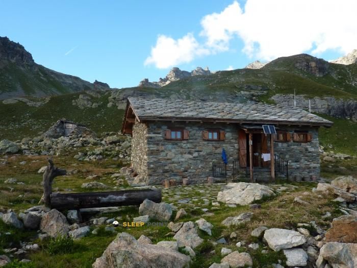

Discover the vastness of bivacco luca reboulaz, sentiero cima bianca, chomioÿ, nus, valle de aosta, italia by spending the night at the Refuge-bivouac du Lac de Luseney (Luca Reboulaz) refuge. It sits at 2574 meters, offering a unique balcony over the natural landscape. Find it on the map at latitude 45.864 and longitude 7.513.
3.8°C
Feels like: 0.2°C6.4 km/h
Gusts: 7.6 km/h3480 m
Snow lineUV 2.7
Clouds: 82% 13.7 mm
 20.3 km/h
 UV máx: 6.95
 05:41
05:41
 21:14
0.4 mm
21.6 km/h
UV máx: 7.7
05:41
21:15
0 mm
15 km/h
UV máx: 7.75
05:40
21:16
0 mm
8.8 km/h
UV máx: 7.65
05:40
21:17
0 mm
11 km/h
UV máx: 6.55
05:40
21:17
2.25 mm
16.3 km/h
UV máx: 6.85
05:39
21:18
0 mm
8.1 km/h
UV máx: 7.7
05:39
21:19
21:14
0.4 mm
21.6 km/h
UV máx: 7.7
05:41
21:15
0 mm
15 km/h
UV máx: 7.75
05:40
21:16
0 mm
8.8 km/h
UV máx: 7.65
05:40
21:17
0 mm
11 km/h
UV máx: 6.55
05:40
21:17
2.25 mm
16.3 km/h
UV máx: 6.85
05:39
21:18
0 mm
8.1 km/h
UV máx: 7.7
05:39
21:19
At 2574 meters, the Refuge-bivouac du Lac de Luseney (Luca Reboulaz) it is already located in a mountain strip where the terrain usually marks the pace of the day and where the weather can change quickly. In the surroundings of Nus, within the Aosta Valley, it works mainly as a support for mountaineers who move along long routes or chain steps between valleys, rather than as a simple isolated destination. Its position fits well in a logic of journey, with the reference of Tour du Cervin and other trails in the area, and may also have an interest as a point of withdrawal or phase division when the progression is longer than expected.
The nearby relief reinforces that alpine character. The proximity of cimas like the Becca di Luseney which clearly exceeds 3000 meters, indicates an atmosphere of height in which orientation changes, stony slopes and more open sections can have a great influence on the effort and the thermal sensation. There is no data here to set times or exact hardness of access, but the shelter's height and its lace in a network of mountain trails point to an approach that should be put forward with margin, especially if it is linked to other itineraries or if it is planned to continue towards the hills and summits of the sector.
In practical planning, the presence of a very close source, a few meters away, a relevant detail in a shelter of this type is highlighted because it allows to better adjust the water load when it comes. Even so, in the high mountain, it is always appropriate to maintain a prudent approach: to review conditions before leaving, not to entrust the whole day to a single option of passage and to consider this bivouac as a useful resource to reorganize the route if time, visibility or tiredness force to change the plan on the ground.


📏 2.6 Km
⛰️ 2007 m

📏 2.8 Km
⛰️ 2482 m

📏 3.2 Km
⛰️ 2530 m

📏 3.3 Km
⛰️ 2652 m

📏 3.9 Km
⛰️ 2906 m

📏 5.9 Km
⛰️ 2704 m

📏 6 Km
⛰️ 2790 m

📏 6.1 Km
⛰️ 2909 m
Download the app and start looking for the shelter of your next adventure


Find a place to sleep before night falls.


