Mountain refuge Petit abri en pierres des Routières

We have it listed in the app!


            Mountain refuge Petit abri en pierres des Routières in petit abri en pierres des routières, route militaire des rochilles, valloire, saint-jean-de-maurienne, saboya, auvergne-rhône-alpes, francia metropolitana, 73450, francia
Five orange stars in a horizontal row representing a five-star rating.

Petit abri en pierres des Routières

Lat: 45.077xxx – Lon: 6.461xxx
📍 petit abri en pierres des routières, route militaire des rochilles, valloire, saint-jean-de-maurienne, saboya, auvergne-rhône-alpes, francia metropolitana, 73450, francia
Petit abri en pierres des Routières

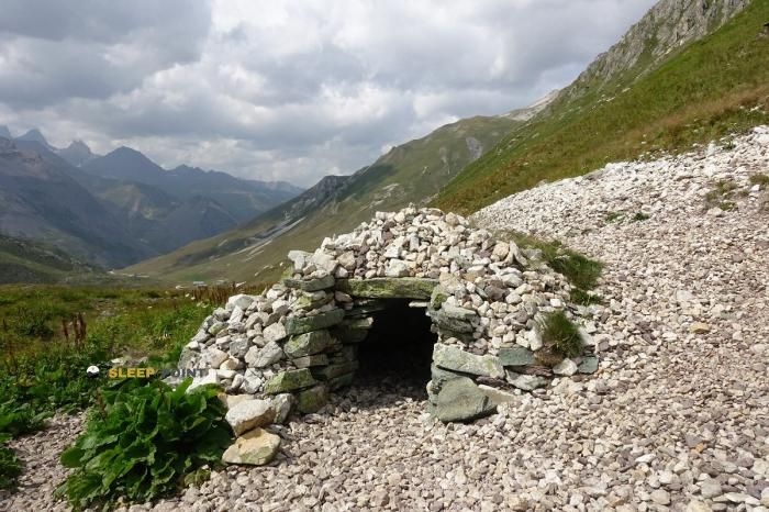
At 2280 meters above sea level, nestled in petit abri en pierres des routières, route militaire des rochilles, valloire, saint-jean-de-maurienne, saboya, auvergne-rhône-alpes, francia metropolitana, 73450, francia, stands the Petit abri en pierres des Routières refuge. It is the perfect stop to spend the night or catch your breath. GPS coordinates: 45.077, 6.461.

See more
See more
Usuario

Lucas Martinez

Premium user

Live weather: Petit abri en pierres des Routières

The current weather in Petit abri en pierres des Routières indicates a temperature of 7.4°C, although the 9.8 km/h wind makes it feel like 3.3°C. Watch out for gusts of 16.2 km/h. The snow altitude (freezing level 0°) is around 3900 m and today we will reach a high of 12.5°C.
Temperature

7.4°C

Feels like: 3.3°C
Wind

9.8 km/h

Gusts: 16.2 km/h
Freezing level 0°

3900 m

Snow line
Sky & UV

UV 0.05

Clouds: 100%

Next 48 hours evolution

7-day forecast

04/06
12.5° -0.2°
20.2 mm 17.6 km/h UV máx: 6.2
05:48 21:16
05/06
7.5° 0.1°
0.8 mm 13.4 km/h UV máx: 8.15
05:48 21:16
06/06
12.5° 5.3°
0 mm 16.7 km/h UV máx: 8.25
05:48 21:17
07/06
15° 3.4°
0 mm 12.6 km/h UV máx: 8.15
05:47 21:18
08/06
16.3° 6.5°
0 mm 16.2 km/h UV máx: 7.75
05:47 21:19
09/06
10.2° 3.8°
0.9 mm 15.5 km/h UV máx: 6.35
05:47 21:19
10/06
14.8° 1.3°
0 mm 11 km/h UV máx: 7.85
05:46 21:20

Between Rochilles and the Galibier axis

In the field of Rochilles , above Valloire and at 2,280 meters of altitude, the Petit abri in peerres des Routières appears on a clearly open, high mountain terrain very exposed to time changes. The reference of the route militaire des Rochilles helps to place it in a strip of passage between hills, loins and lacustrous cubes, within the environment that links the Cercas massif with the area of Galibier . More than a stay shelter, it fits as a small support coat in an area where wind, fog or a storm can change the day quickly.

Their practical interest is linked to the movement by journey routes. In this environment, routes such as the Tour du Mont Thabor and GR 50 , in addition to local tracks to the Seuil des Rochilles, Lac Rond or the Crête de la Ponsonnière. This network of roads gives it value as a point of withdrawal, short pause or intermediate guard when you chain steps between valleys and hills, rather than as a basis for concrete ascension.

The landscape here does not respond to a forest mountain, but to a transition to more mineral land. This level is dominated by clear spaces, stony slopes and a sense of altitude, with wide visual orientation but also with less natural protection. This influences the march: the shelter can be useful in long days of liaison, especially when the terrain requires attention in orientation or when weather reduces visibility.

In the logistics it is necessary to have autonomy. There is a source less than a kilometre away, but in the mountain that reference does not replace the water forecast before leaving or the field check. It is also prudent not to take for granted more services than are known. For its location and character, this coat is better understood as a functional resource within a journey through the Rochilles environment and the steps near the Galibier than as a destination in itself.

Hiking routes from the refuge

GR 50

Tour du Parc National des Écrins

↔ 369 km
Local

Tour du Mont Thabor

↔ Variable distance
Local

Lac Blanc - Crête de la Ponsonnière

↔ Variable distance
Local

Crête de la Ponsonnière - Col de la Ponsonnière

↔ Variable distance
Local

Seuil des Rochilles - Lac Rond

↔ Variable distance
Local

Col de Névache - ?

↔ Variable distance
Local

Lac Rond - Refuge des Drayères

↔ Variable distance
Local

Pont de Pierre - Refuge des Drayères

↔ Variable distance

Nearby water fountains

Fuente

975 m
Lat: 0 Lon: 0

Fuente

2.28 Km
Lat: 0 Lon: 0

Fuente

3.69 Km
Lat: 0 Lon: 0

Fuente

4.23 Km
Lat: 0 Lon: 0

Fuente

5.36 Km
Lat: 0 Lon: 0

Fuente

5.81 Km
Lat: 0 Lon: 0

Fuente

5.85 Km
Lat: 0 Lon: 0

Fuente

5.99 Km
Lat: 0 Lon: 0
FAQ

Frequently asked questions

Pregunta frecuente
At what exact altitude is the Petit abri en pierres des Routières refuge located?
The Petit abri en pierres des Routières refuge is located at an altitude of 2280 meters above sea level, in the natural surroundings of petit abri en pierres des routières, route militaire des rochilles, valloire, saint-jean-de-maurienne, saboya, auvergne-rhône-alpes, francia metropolitana, 73450, francia.
Pregunta frecuente
What are the GPS coordinates of the Petit abri en pierres des Routières refuge?
To locate the Petit abri en pierres des Routières refuge on your GPS or map, use the following coordinates: Latitude 45.077 and Longitude 6.461.
Pregunta frecuente
Is it necessary to carry a GPS to reach the Petit abri en pierres des Routières refuge?
It is always highly recommended to carry a GPS device, a route track, or a topographic map in the mountains. You can use the coordinates 45.077, 6.461 to locate this refuge precisely.
More areas

Other areas

Collaborative

Together we improve

image

Send your photos

You can upload photos of shelters and update their status so other users know if they can go there.

Get started
Get started
image

Rate the shelter

Leave your comments to rate the shelter’s condition. In the mountains, we look after each other.

Get started
Get started
image

Add new ones

Did we miss any? Publish the shelters you know so everyone can use them.

Get started
Get started
Download for free from the Apple App Store and Play Store.

Download the app and start looking for the shelter of your next adventure

Aplicación móvil para encontrar refugios de montaña donde dormir
Aplicación móvil para encontrar refugios de montaña donde dormir.
Mapa interactivo de refugios de montaña en los Pirineos dentro de la app
Mapa de refugios de montaña para senderismo y trekking en la app.
Pantalla con información de refugio de montaña con altitud capacidad y servicios
Pantalla con información de refugio de montaña con altitud capacidad y servicios.
Detalles de refugio de montaña con servicios y meteorología en aplicación móvil
Detalles de refugio de montaña con servicios y meteorología en aplicación móvil.
Aplicación para explorar refugios de montaña mediante mapa interactivo
Aplicación para explorar refugios de montaña mediante mapa interactivo.
Ficha completa de refugio de montaña con opiniones y servicios
Ficha completa de refugio de montaña con opiniones y servicios.
Información detallada de refugio en app para montañeros
Información detallada de refugio en app para montañeros.
Listado de refugios de montaña para senderismo y trekking
Listado de refugios de montaña para senderismo y trekking.
Explorar refugios de montaña desde una aplicación móvil
Explorar refugios de montaña desde una aplicación móvil.