Mountain refuge Malga Campostril
We have it listed in the app!
We have it listed in the app!
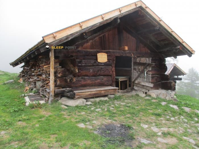

With a privileged location in strada di campastril, caderzone terme, comunità delle giudicarie, provincia de trento, trentino-alto adigio, 38080, italia, the Malga Campostril refuge awaits you at 1831 meters of altitude. Note its position (46.137, 10.727) before starting your route through the mountain range or massif.
9.7°C
Feels like: 8.2°C4.1 km/h
Gusts: 10.8 km/h3130 m
Snow lineUV 0.1
Clouds: 0% 4.9 mm
 9.2 km/h
 UV máx: 7.25
 05:28
05:28
 21:02
8 mm
14.2 km/h
UV máx: 3.4
05:27
21:03
37.85 mm
13.3 km/h
UV máx: 6.85
05:27
21:04
4.9 mm
8.7 km/h
UV máx: 6.55
05:26
21:04
0.9 mm
12.5 km/h
UV máx: 6.35
05:26
21:05
11.7 mm
11.2 km/h
UV máx: 7.5
05:26
21:06
26.4 mm
10.4 km/h
UV máx: 4.35
05:25
21:06
21:02
8 mm
14.2 km/h
UV máx: 3.4
05:27
21:03
37.85 mm
13.3 km/h
UV máx: 6.85
05:27
21:04
4.9 mm
8.7 km/h
UV máx: 6.55
05:26
21:04
0.9 mm
12.5 km/h
UV máx: 6.35
05:26
21:05
11.7 mm
11.2 km/h
UV máx: 7.5
05:26
21:06
26.4 mm
10.4 km/h
UV máx: 4.35
05:25
21:06
Malga Campostril is located in the sector of Caderzone Terme, in Val Rendena inside the Trentino- High Adigy. At 1831 meters, it is left in a strip of medium-high mountain where the relief begins to gain alpine character and where the orientation on the ground matters more than the simple proximity to the valley. The reference of strada di Campatril helps to place it on the side that links the high slopes on the region with itineraries that are entered to close cords and elevations.
Your practical interest is in serving as support for mountain tours that are not limited to a short walk. In the surroundings there are signposted trails and some equipped sections, such as those of Val di Sacco or Scala Santa, which suggests a varied terrain and an approach that can require attention according to the chosen itinerary. It also remains close to tops as Spadalone , High Corn o La Costaccia, so that it can fit as an intermediate reference to move between high and objective slopes of crest or antecimal.
For those who plan the day, it is appropriate to understand this point more as an element of mountain logistics than as an isolated destination. It may be useful to divide routes, link local paths or raise ascension in the upper area over Val Rendena, especially if you seek continuity of route and not just a rise and down the same path. The most appropriate profile is that of a senderist used to mountain terrain and to decide on map which access fits best with the day.
As for water, there is a very close source, a few meters away, and several more in a short radius, although in mountain it is always reasonable to check their real state before depending on them. Weather and visibility can change quickly at this level, so basic autonomy, prior consultation of the itinerary and good reading of the relief remain key factors.


📏 7.3 Km
⛰️ 1960 m

📏 13.2 Km
⛰️ 1735 m

📏 13.4 Km
⛰️ 2271 m

📏 13.8 Km
⛰️ 1450 m

📏 13.8 Km
⛰️ 1470 m

📏 18.1 Km
⛰️ 2790 m

📏 45.2 Km
⛰️ 1703 m

📏 45.8 Km
⛰️ 2600 m
Download the app and start looking for the shelter of your next adventure


Find a place to sleep before night falls.


