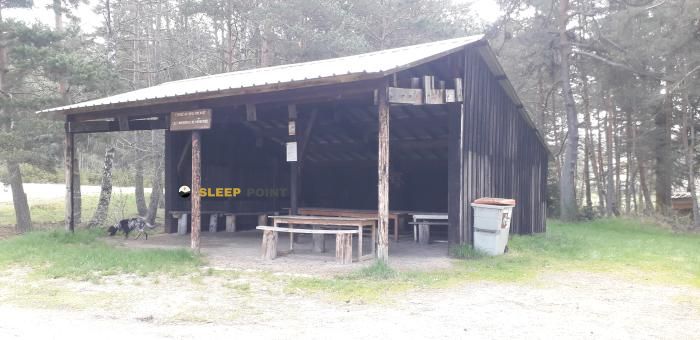
Mountain refuge Le Castrum
We have it listed in the app!
We have it listed in the app!


Strategically located in lotissement l'esperounado, saint-alban-sur-limagnole, mende, lozère, occitania, francia metropolitana, 48120, francia, the Le Castrum refuge makes exploring the area easier. At 1060 meters above sea level, this point of interest (44.792, 3.39) is a vital resource when planning your route.
9.5°C
Feels like: 8.3°C4.7 km/h
Gusts: 6.8 km/h4130 m
Snow lineUV 0
Clouds: 100% 8.5 mm
 11.6 km/h
 UV máx: 0.75
 06:02
06:02
 21:27
0 mm
17.2 km/h
UV máx: 7.4
06:01
21:28
0 mm
18.5 km/h
UV máx: 6.85
06:01
21:28
0 mm
6.4 km/h
UV máx: 6.8
06:01
21:29
2.1 mm
15.4 km/h
UV máx: 7.4
06:00
21:30
0 mm
18.7 km/h
UV máx: 7.25
06:00
21:30
0 mm
12.5 km/h
UV máx: 7.45
06:00
21:31
21:27
0 mm
17.2 km/h
UV máx: 7.4
06:01
21:28
0 mm
18.5 km/h
UV máx: 6.85
06:01
21:28
0 mm
6.4 km/h
UV máx: 6.8
06:01
21:29
2.1 mm
15.4 km/h
UV máx: 7.4
06:00
21:30
0 mm
18.7 km/h
UV máx: 7.25
06:00
21:30
0 mm
12.5 km/h
UV máx: 7.45
06:00
21:31
Le Castum appears in the environment of Saint-Alban-sur-Limagnole , in Lozère at 1060 meters altitude. More than a shelter associated with a great concrete ascension, it fits better in a practical reading of the land: a mountain average, in a transition area between inhabited nuclei, open lomas and soft reliefs where the orientation depends a lot on the network of roads and on the slope on which it is reached.
In this sector of Occitania there are no data from immediate summits or defined alpine itineraries, so its usefulness is mainly understood as support for half-mountain displacements or through the Saint- Alban area. The local context links with the Via Podiensis del Camino de Santiago, which helps to place it in a transit territory, although it is not appropriate to deduce for it exact access or direct stages without checking current mapping.
The approach can change quite well according to the input side: in this type of relief, small orientation changes influence the continuity of the advance, the exposure to the wind and the state of the ground, especially with rain or cold. The altitude does not place it in strict high mountain, but it does place it in a strip where time can harden a day if combined with fog, humidity or short days.
In logistical terms, the most useful data is water: the registered sources are relatively far, more than 4 km away the nearest. This suggests going out with sufficient autonomy and not having immediate supply in the vicinity. As there are no close routes or summits in the available information, the most prudent thing is to understand this mountain shelter in Lozère as a local point of support whose function depends above all on the itinerary that each mountaineer tracts on this part of Saint-Alban-sur-Limagnole .


📏 1.2 Km
⛰️ 965 m

📏 6.6 Km
⛰️ 1290 m

📏 8.7 Km
⛰️ 1180 m

📏 14.7 Km
⛰️ 1041 m

📏 15.1 Km
⛰️ 1085 m

📏 15.4 Km
⛰️ 1216 m

📏 15.9 Km
⛰️ 1091 m

📏 17.1 Km
⛰️ 1213 m
Download the app and start looking for the shelter of your next adventure


Find a place to sleep before night falls.


