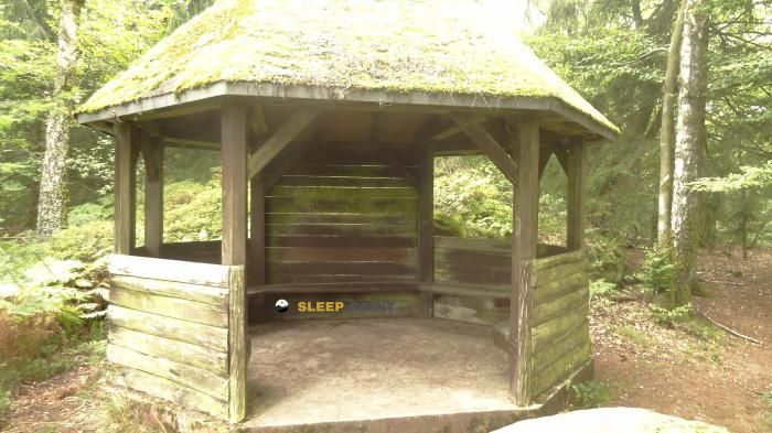
Mountain refuge Grotte de l'Altenberg
We have it listed in the app!
We have it listed in the app!
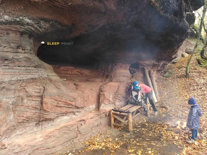

The Grotte de l'Altenberg refuge acts as a base camp for the summits and routes of chemin de l'altenberg, boxmuehl, neuwiller-lès-saverne, saverne, bajo-rin, gran este, francia metropolitana, 67330, francia. At 405 meters of elevation, its coordinates (48.849, 7.386) represent safety after a long day of effort.
16.1°C
Feels like: 14°C14.5 km/h
Gusts: 37.4 km/h3490 m
Snow lineUV 0
Clouds: 100% 1.8 mm
 18 km/h
 UV máx: 2.95
 05:29
05:29
 21:28
0.7 mm
15.9 km/h
UV máx: 5.4
05:29
21:28
2.1 mm
11.4 km/h
UV máx: 6.85
05:28
21:29
0 mm
14.5 km/h
UV máx: 6.4
05:28
21:30
0.6 mm
9.9 km/h
UV máx: 6.55
05:27
21:31
5.7 mm
18.8 km/h
UV máx: 6.5
05:27
21:32
0 mm
7 km/h
UV máx: 6.55
05:27
21:32
21:28
0.7 mm
15.9 km/h
UV máx: 5.4
05:29
21:28
2.1 mm
11.4 km/h
UV máx: 6.85
05:28
21:29
0 mm
14.5 km/h
UV máx: 6.4
05:28
21:30
0.6 mm
9.9 km/h
UV máx: 6.55
05:27
21:31
5.7 mm
18.8 km/h
UV máx: 6.5
05:27
21:32
0 mm
7 km/h
UV máx: 6.55
05:27
21:32
The passage of GR 532 by the sector of Neuwiller-lès-Saverne helps to place this cavity - shelter within a wider network of trails, on the edge of the regional natural park of the Vosgos del Norte. At 405 meters of altitude, in the surroundings of the chemin de l'Altenberg and the area of Boxmudihl, it works mainly as a reference of coat and orientation on a low mountain but very compartmentalized by looms, forests and small rocky highlights.
Its position is closely linked to the immediate relief of Altenberg , almost above the point, and near elevations such as Pfannenfelsen, Spitzberg or Katzenberg. This is not a high-mountain site or a summit shelter, but rather a support in forest and wavy terrain where map navigation continues to make sense, especially when local signposted trails are linked to larger routes. In this context, it can serve to divide a day, solve a long pause or take it as a clear reference by moving between the hills and soft crests of the area.
For those who advance through the GR or local tracks such as the Sentier Géologique, it is appropriate to assess whether the deviation really fits the intended stage. The utility of the place depends less on a great ascension and more on its logistical role within a framework of roads where changes in direction are frequent. It may also have an interest as a short base for the immediate heights of the Altenberg and its neighbouring hills, always within a context of half a forest mountain.
Planning must be prudent. The invented sources do not appear attached to the shelter, and the nearest one is just over 2 kilometers away, so it is not appropriate to have water at the point. In a senderist transit area but with solitary sections, it is reasonable to carry basic autonomy, to review mapping and to adapt the day to the meteorology and visibility of the terrain.


Download the app and start looking for the shelter of your next adventure


Find a place to sleep before night falls.