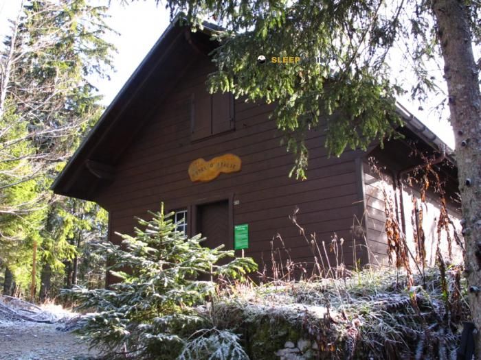
Mountain refuge Chalet Gaillard
We have it listed in the app!
We have it listed in the app!


With a privileged location in le chalet gaillard, chemin des essarts, bellefontaine, saint-claude, jura, borgoña-franco condado, francia metropolitana, 39400, francia, the Chalet Gaillard refuge awaits you at 1232 meters of altitude. Note its position (46.563, 6.122) before starting your route through the mountain range or massif.
8.7°C
Feels like: 6.9°C6.4 km/h
Gusts: 20.2 km/h3770 m
Snow lineUV 0
Clouds: 100% 23 mm
23 mm
 16.9 km/h
 UV máx: 5.1
 05:44
05:44
 21:23
0.1 mm
12 km/h
UV máx: 6.9
05:44
21:24
0.1 mm
18.6 km/h
UV máx: 7.4
05:43
21:24
0 mm
9.4 km/h
UV máx: 6.35
05:43
21:25
4.2 mm
14.5 km/h
UV máx: 6.5
05:42
21:26
12.6 mm
15.5 km/h
UV máx: 6.7
05:42
21:27
0 mm
10.9 km/h
UV máx: 7.2
05:42
21:27
21:23
0.1 mm
12 km/h
UV máx: 6.9
05:44
21:24
0.1 mm
18.6 km/h
UV máx: 7.4
05:43
21:24
0 mm
9.4 km/h
UV máx: 6.35
05:43
21:25
4.2 mm
14.5 km/h
UV máx: 6.5
05:42
21:26
12.6 mm
15.5 km/h
UV máx: 6.7
05:42
21:27
0 mm
10.9 km/h
UV máx: 7.2
05:42
21:27
The passage of GR 5 by the Jura gives context to this mountain shelter in Bellefontaine. At 1,232 metres, Chalet Gaillard better fit as a point of support or reference of passage than as an isolated destination, especially for those who travel long routes such as the GR 5 Jura or the Tour de la Haute Bienne . It also remains in the surroundings of local tours such as La Chaux Sèche, which extends its usefulness for days of journey or links across the mountain.
The terrain of this part of the Jura combines wavy relief, forest masses and open lomas where the orientation can depend more on the map and the continuity of the itinerary than on obvious alpine references. In this context, the shelter functions as a recognizable point within a wider network of roads. Close summits like Roche Champion , Crêt à la Dame or La Roche Devant help to read the landscape and place the area in a moderate mountain environment, without the need to associate it with technical ascension.
To plan access it is necessary to think about basic autonomy. The invented sources are several kilometres away, so it is not wise to have immediate water next to the shelter. The weather of the Jura massif can change quickly and, in long routes, the combination of forest, track crosses and variable visibility requires attention to navigation. By location and network of trails, it can serve both to break a journey and to organize a return exit, according to the chosen route.


📏 0.7 Km
⛰️ 1202 m
📏 1.1 Km
⛰️ 1293 m

📏 1.1 Km
⛰️ 1280 m

📏 1.2 Km
⛰️ 1250 m

📏 1.2 Km
⛰️ 1234 m

📏 1.4 Km
⛰️ 1260 m

📏 1.5 Km
⛰️ 1225 m

📏 1.9 Km
⛰️ 1187 m
Download the app and start looking for the shelter of your next adventure


Find a place to sleep before night falls.


