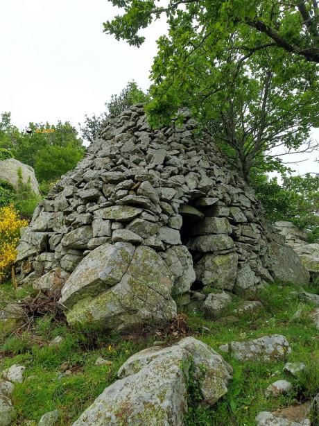
Mountain refuge Cabanes de Mataporc
We have it listed in the app!
We have it listed in the app!


Prepare your backpack and head to cabanes de mata porcs, chemin al bertranou, laroque-des-albères, céret, pirineos orientales, occitania, francia metropolitana, 66740, francia. There you will find the Cabanes de Mataporc refuge at 360 meters of elevation. An essential stop along the way (Lat: 42.509, Lon: 2.949) for any mountain enthusiast.
20.8°C
Feels like: 20.3°C2.4 km/h
Gusts: 10.4 km/h4200 m
Snow lineUV 3.95
Clouds: 100% 25.3 mm
 15.2 km/h
 UV máx: 7.2
 06:12
06:12
 21:20
0 mm
15.5 km/h
UV máx: 5.9
06:11
21:21
0 mm
10.6 km/h
UV máx: 6.9
06:11
21:22
0 mm
9.4 km/h
UV máx: 7.1
06:11
21:22
0 mm
15.6 km/h
UV máx: 7.75
06:10
21:23
0 mm
19.8 km/h
UV máx: 7.35
06:10
21:24
0 mm
13 km/h
UV máx: 7.35
06:10
21:24
21:20
0 mm
15.5 km/h
UV máx: 5.9
06:11
21:21
0 mm
10.6 km/h
UV máx: 6.9
06:11
21:22
0 mm
9.4 km/h
UV máx: 7.1
06:11
21:22
0 mm
15.6 km/h
UV máx: 7.75
06:10
21:23
0 mm
19.8 km/h
UV máx: 7.35
06:10
21:24
0 mm
13 km/h
UV máx: 7.35
06:10
21:24
Cabans de Mataporc in the sector of the Laroque -des-Albères within the French Eastern Pyrenees. Its position, at 360 meters of altitude, places it closer to the low and medium slopes of the massif than to the crest environment, something relevant to those who travel long days between the pediemonte and the cords that rise to the border axis. In this context it appears linked to the passage of the HRP and GR 10 two clear references to understand their function: not so much as an isolated destination, but as a useful safeguard within a journey or a link between stages.
From this area, the relief quickly gains height towards summits like the Puig Neulós , roof of the Albera and natural reference of the border cord, in addition to other nearby highlights such as the Puig Pregon or the Pic dels Quatre Termes. This gives the shelter interest for hiking of half and long distance in a mountain where the roads can connect valley backgrounds, hills and divisives on very different routes. It also fits local routes to the Massane Tour or the Château d'Ultrera, within a Mediterranean mountain terrain where the direction of the itinerary and the exposure to heat can weigh as much as the distance.
In the logistics part it is appropriate to propose the exit with autonomy. There is a source just over 1 km, a reasonable reference to the map, but it should not be considered safe without prior verification, especially in dry periods. Beyond that point, the other developments are already far further away. For whom I use Cabans de Mataporc In support, it is wise to arrive with sufficient water and with clear planning of the next section, especially if the intention is to link with long routes or to gain height towards the divisive.


📏 2.4 Km
⛰️ 533 m

📏 2.4 Km
⛰️ 533 m

📏 3.7 Km
⛰️ 1052 m

📏 3.9 Km
⛰️ 940m m

📏 5 Km
⛰️ 1142 m

📏 5.1 Km
⛰️ 1015 m
📏 5.6 Km
⛰️ 945 m

📏 6.5 Km
⛰️ 474 m
Download the app and start looking for the shelter of your next adventure


Find a place to sleep before night falls.


