Mountain refuge Cabane pastoral des Mariailles

We have it listed in the app!


            Mountain refuge Cabane pastoral des Mariailles in route forestière de mariailles, casteil, prades, pirineos orientales, occitania, francia metropolitana, 66820, francia
Five orange stars in a horizontal row representing a five-star rating.

Cabane pastoral des Mariailles

Lat: 42.498xxx – Lon: 2.41xxx
📍 route forestière de mariailles, casteil, prades, pirineos orientales, occitania, francia metropolitana, 66820, francia
Cabane pastoral des Mariailles

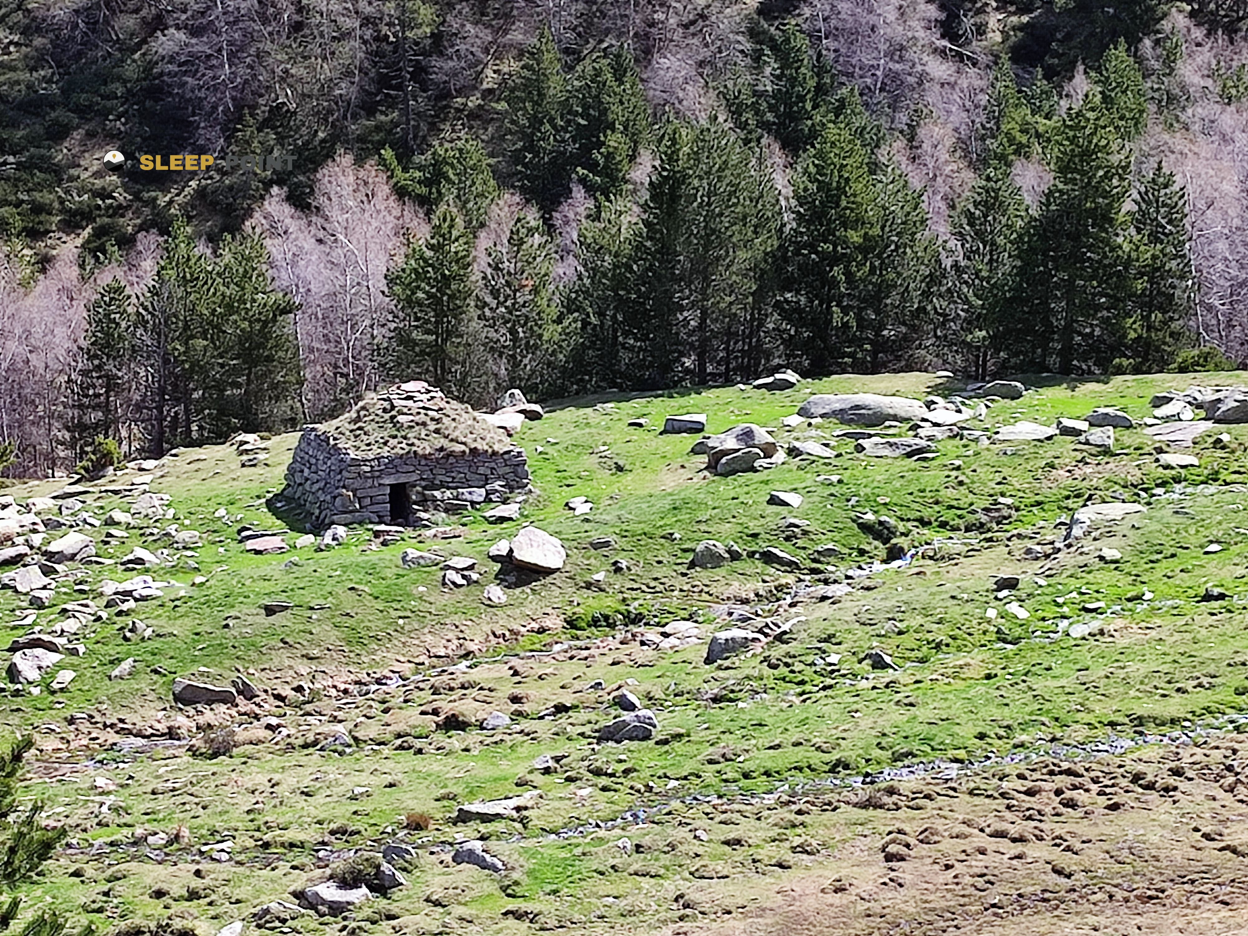
Protected by the wild surroundings of route forestière de mariailles, casteil, prades, pirineos orientales, occitania, francia metropolitana, 66820, francia, the Cabane pastoral des Mariailles refuge is your best ally at 1691 meters of elevation. Once you reach its coordinates (42.498, 2.41), you can enjoy a well-deserved mountain rest.

See more
See more
Usuario

Lucas Martinez

Premium user

Live weather: Cabane pastoral des Mariailles

Before heading to Cabane pastoral des Mariailles, check the weather: we currently have 14.9°C (feels like 14.1°C). With wind gusts reaching 12.6 km/h and a freezing level around 4260 meters, the daytime high will not exceed 15°C.
Temperature

14.9°C

Feels like: 14.1°C
Wind

5 km/h

Gusts: 12.6 km/h
Freezing level 0°

4260 m

Snow line
Sky & UV

UV 4.15

Clouds: 100%

Next 48 hours evolution

7-day forecast

04/06
15° 6.5°
24.73 mm 10.1 km/h UV máx: 5.65
06:14 21:23
05/06
10.8° 3.2°
0 mm 11.1 km/h UV máx: 6.2
06:14 21:23
06/06
16.5°
0.8 mm 8.4 km/h UV máx: 6.7
06:13 21:24
07/06
18.7°
0.4 mm 6.6 km/h UV máx: 7.65
06:13 21:25
08/06
21.3° 12.1°
0.6 mm 4.9 km/h UV máx: 7.7
06:13 21:25
09/06
16.3° 9.5°
9.3 mm 6.7 km/h UV máx: 6.5
06:12 21:26
10/06
13° 9.5°
9 mm 7.3 km/h UV máx: 7.8
06:12 21:26

Between the Canigó Tour and the HRP

In the Mariailles sector, on the Casteil , this pastoral cabin fits well in a crossing of mountain interests: it serves so much for those who travel the Tour del Canigó as for those who link sections of the HRP or GR 10 in the Cannigo massif. Its position, at 1691 meters, already places it in a strip of medium-high mountain where the forest leaves way to a more open terrain and where time can change quickly. In that context, the Cabane pastoral des Mariailles It works mainly as a step support or as a short base to gain height towards the peaks that dominate the massif, with references as clear as the Pic du Canigou or the Pic des Sept Hommes, not yet left in the harshest part of the relief.

Practical reading of the environment

For the mountaineer who seeks to divide the day or to be located near the classic itineraries of the Canigó, his interest is in that intermediate position between valley and crest. It should not be read as a service shelter, but as a useful point in an autonomy strategy. The invented sources are several kilometres away, so the water should not be considered safe in the vicinity and should be planned before leaving. It is also appropriate to take into account the weather exposure of the massif, which is marked by the gap that separates it from the lower lands of the Rosellon: although the altitude is not extreme for pirenaic standards, the environment can be hardened by wind, fog or sudden changes. This is why it is especially practical for people with cross-country experience and for mountaineers who want to approach the Canigó with a simple logistics, but not dependent on finding immediate resources on the ground.

Hiking routes from the refuge

GR 83

Camí del nord o del Canigó

↔ 201.77 km
HRP

HRP Étape 36

↔ Variable distance
HRP

HRP Étape 37

↔ Variable distance
GR 10

La traversée des Pyrénées - sec.2

↔ Variable distance
GR 10

La traversée des Pyrénées - sec.1

↔ Variable distance
Tour del Canigó

Tour del Canigó

↔ 63 km
Local

Refugis del Torb

↔ 78 km
Local

De la Manche aux Pyrénées 24, Sournia - Bourg-Madame

↔ Variable distance

Nearby peaks

Pic du Canigou

2784.66 m
Lat: 42.5189 Lon: 2.4566

Pic Joffre

2362 m
Lat: 42.5329 Lon: 2.452

Pic des Sept Hommes

2651 m
Lat: 42.4848 Lon: 2.4396

Puig del Roc Negre

2714 m
Lat: 42.5001 Lon: 2.4712

Pic de la Falguerosa

1126 m
Lat: 42.5355 Lon: 2.3818

Pic de la Pena

1062 m
Lat: 42.538 Lon: 2.3849

Pic de l'Alzina

1009 m
Lat: 42.5375 Lon: 2.3999

Pic Bas del Canigo

Altitude not available
Lat: 42.5167 Lon: 2.4606

Nearby water fountains

Fuente

4 Km
Lat: 42.5167 Lon: 2.4606

Fuente

4.82 Km
Lat: 42.5167 Lon: 2.4606

Fuente

4.83 Km
Lat: 42.5167 Lon: 2.4606

Fuente

5.9 Km
Lat: 42.5167 Lon: 2.4606

Fuente

6.06 Km
Lat: 42.5167 Lon: 2.4606

Fuente

6.87 Km
Lat: 42.5167 Lon: 2.4606

Font Mercé

6.99 Km
Lat: 42.5167 Lon: 2.4606

Fuente

7.02 Km
Lat: 42.5167 Lon: 2.4606
FAQ

Frequently asked questions

Pregunta frecuente
At what exact altitude is the Cabane pastoral des Mariailles refuge located?
The Cabane pastoral des Mariailles refuge is located at an altitude of 1691 meters above sea level, in the natural surroundings of route forestière de mariailles, casteil, prades, pirineos orientales, occitania, francia metropolitana, 66820, francia.
Pregunta frecuente
What are the GPS coordinates of the Cabane pastoral des Mariailles refuge?
To locate the Cabane pastoral des Mariailles refuge on your GPS or map, use the following coordinates: Latitude 42.498 and Longitude 2.41.
Pregunta frecuente
Is it necessary to carry a GPS to reach the Cabane pastoral des Mariailles refuge?
It is always highly recommended to carry a GPS device, a route track, or a topographic map in the mountains. You can use the coordinates 42.498, 2.41 to locate this refuge precisely.
More areas

Other areas

Collaborative

Together we improve

image

Send your photos

You can upload photos of shelters and update their status so other users know if they can go there.

Get started
Get started
image

Rate the shelter

Leave your comments to rate the shelter’s condition. In the mountains, we look after each other.

Get started
Get started
image

Add new ones

Did we miss any? Publish the shelters you know so everyone can use them.

Get started
Get started
Download for free from the Apple App Store and Play Store.

Download the app and start looking for the shelter of your next adventure

Aplicación móvil para encontrar refugios de montaña donde dormir
Aplicación móvil para encontrar refugios de montaña donde dormir.
Mapa interactivo de refugios de montaña en los Pirineos dentro de la app
Mapa de refugios de montaña para senderismo y trekking en la app.
Pantalla con información de refugio de montaña con altitud capacidad y servicios
Pantalla con información de refugio de montaña con altitud capacidad y servicios.
Detalles de refugio de montaña con servicios y meteorología en aplicación móvil
Detalles de refugio de montaña con servicios y meteorología en aplicación móvil.
Aplicación para explorar refugios de montaña mediante mapa interactivo
Aplicación para explorar refugios de montaña mediante mapa interactivo.
Ficha completa de refugio de montaña con opiniones y servicios
Ficha completa de refugio de montaña con opiniones y servicios.
Información detallada de refugio en app para montañeros
Información detallada de refugio en app para montañeros.
Listado de refugios de montaña para senderismo y trekking
Listado de refugios de montaña para senderismo y trekking.
Explorar refugios de montaña desde una aplicación móvil
Explorar refugios de montaña desde una aplicación móvil.