Mountain refuge Cabane
We have it listed in the app!
We have it listed in the app!
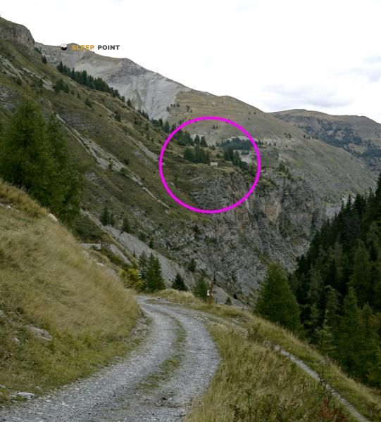

The Cabane refuge (chemin de gialorgue, saint-dalmas-le-selvage, niza, alpes marítimos, provenza-alpes-costa azul, francia metropolitana, 06660, francia) is a classic meeting point for mountaineers and hikers. At 1750 meters, its coordinates 44.28, 6.852 mark the end of a stage or the beginning of a new adventure.
9.5°C
Feels like: 6.3°C7.4 km/h
Gusts: 13 km/h4180 m
Snow lineUV 0.1
Clouds: 65% 6 mm
6 mm
 22.1 km/h
 UV máx: 7.55
 05:50
05:50
 21:11
0.1 mm
21.3 km/h
UV máx: 7.85
05:49
21:12
0 mm
14.1 km/h
UV máx: 8.15
05:49
21:12
0 mm
15.4 km/h
UV máx: 8
05:49
21:13
0 mm
20.8 km/h
UV máx: 7.95
05:48
21:14
0 mm
21.1 km/h
UV máx: 7.3
05:48
21:14
0 mm
9.3 km/h
UV máx: 7.85
05:48
21:15
21:11
0.1 mm
21.3 km/h
UV máx: 7.85
05:49
21:12
0 mm
14.1 km/h
UV máx: 8.15
05:49
21:12
0 mm
15.4 km/h
UV máx: 8
05:49
21:13
0 mm
20.8 km/h
UV máx: 7.95
05:48
21:14
0 mm
21.1 km/h
UV máx: 7.3
05:48
21:14
0 mm
9.3 km/h
UV máx: 7.85
05:48
21:15
On the side of Gialorgue, cabane is located at the end of Saint-Dalmas-le- Selvage, within the French Maritime Alps. At 1,750 metres, it operates as a free shelter in a middle and high mountain area where the relief gains character as it ascends to cords and close to the surroundings of the Mercantour .
Its mountain interest is mainly linked to the passage of crossing routes. The Tour de l'Ubaye by the GR 56 and variants of the Via Alpina , in addition to the routes that link with the sector of the Mont Ténibre and the Tête de l'Enchastraye. More than an isolated destination, it fits as support to divide long days, adjust an approach or reserve forces before gaining more open and higher ground.
The immediate environment also helps to understand its role. On a relatively close radio there are summits like Bec de Marseille , the Tête de Cristel or the Tête de Sanguinière, which points to a wide mountain terrain, with changes in slope and weather that can vary quickly. In this type of location it is appropriate to plan the day with a margin, especially if they are linked collars or long journey routes.
From a logistical point of view, there are several sources at just over a kilometre, a reasonable distance but it is not appropriate to take for granted without checking the flow and conditions of the season. For this reason, although the shelter can be of support, it is still prudent to propose the exit with basic autonomy of water, food and shelter, and not to rely on finding guaranteed resources upon arrival.


📏 3.2 Km
⛰️ 1750 m

📏 5.1 Km
⛰️ 2580 m

📏 5.3 Km
⛰️ 2560 m

📏 5.4 Km
⛰️ 2280 m

📏 5.5 Km
⛰️ 2320 m

📏 7 Km
⛰️ 2200 m

📏 7 Km
⛰️ 2085 m

📏 7 Km
⛰️ 2757 m
Download the app and start looking for the shelter of your next adventure


Find a place to sleep before night falls.


