Mountain refuge Cabane du Plan du Jeu
We have it listed in the app!
We have it listed in the app!
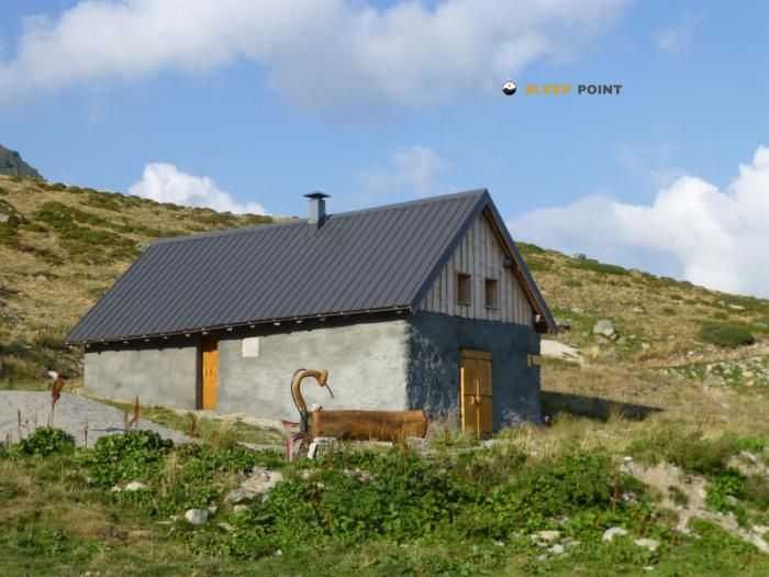

At 1990 meters above sea level, nestled in chalet du plan du jeu, chemin de l'âne, cevins, albertville, saboya, auvergne-rhône-alpes, francia metropolitana, 73730, francia, stands the Cabane du Plan du Jeu refuge. It is the perfect stop to spend the night or catch your breath. GPS coordinates: 45.605, 6.532.
5.4°C
Feels like: 2.6°C3 km/h
Gusts: 4.7 km/h4030 m
Snow lineUV 0
Clouds: 81% 34.4 mm
 13.5 km/h
 UV máx: 5.2
 05:46
05:46
 21:17
2 mm
10.3 km/h
UV máx: 6.15
05:46
21:18
0 mm
13.7 km/h
UV máx: 7.7
05:45
21:19
0.4 mm
9.2 km/h
UV máx: 7.45
05:45
21:20
0.45 mm
15.7 km/h
UV máx: 6.95
05:45
21:20
13.2 mm
12.8 km/h
UV máx: 5.65
05:44
21:21
0 mm
11.1 km/h
UV máx: 7.5
05:44
21:22
21:17
2 mm
10.3 km/h
UV máx: 6.15
05:46
21:18
0 mm
13.7 km/h
UV máx: 7.7
05:45
21:19
0.4 mm
9.2 km/h
UV máx: 7.45
05:45
21:20
0.45 mm
15.7 km/h
UV máx: 6.95
05:45
21:20
13.2 mm
12.8 km/h
UV máx: 5.65
05:44
21:21
0 mm
11.1 km/h
UV máx: 7.5
05:44
21:22
On the high slopes that dominate the Cevins in a clearly mountainous environment, the Cabane du Plan du Jeu appears at 1990 meters as a useful support in the transition between the rising forests and the most open terrain of pastures, lomas and crest of the environment Beaufortain . This level places it in a strip where time can change quickly and where the orientation of the itinerary begins to matter more than in low levels, especially if necklaces or dorsal are linked.
The near relief helps you understand your role. In a relatively short radius, the peaks of Pointe du Riondet , Le Grand Mont , Pointe du Dzonfié or Croix de Sécheron , which draws a medium-high mountain landscape with continuity to crest and panoramic points. It is not just an isolated coat: its position fits well as an intermediate point to distribute days or to gain height before moving on longer routes. In this area there are also known journey routes, including the Tour du Beaufortain its variant and sections of the Grand Tour de Tarentaise , so you may have an interest in both circular routes and in stages of link between valleys.
With a view to planning, it is appropriate to think of mountain autonomy and not to take for granted more equipment than is strictly visible on the ground. The presence of a very close source may be relevant to the water load, although in mountain it is always prudent to check the actual flow rate according to time and conditions. It is also interesting to assess that, although the nearby summits are not extremely distant, the ground can change quickly between comfortable path, tilted slope and sections more exposed to wind or fog. Because of its altitude and its relationship to long-range routes, this shelter fits best as a logistical support on the journey or as a sober basis to move through the high sector between Cevins and the Beaufortain mountains.


📏 0.8 Km
⛰️ 1989 m

📏 1.6 Km
⛰️ 1520 m

📏 1.6 Km
⛰️ 2020 m

📏 2.2 Km
⛰️ 1986 m

📏 2.4 Km
⛰️ 2200 m

📏 2.8 Km
⛰️ 2070 m

📏 2.8 Km
⛰️ 1931 m

📏 3 Km
⛰️ 1447 m
Download the app and start looking for the shelter of your next adventure


Find a place to sleep before night falls.


