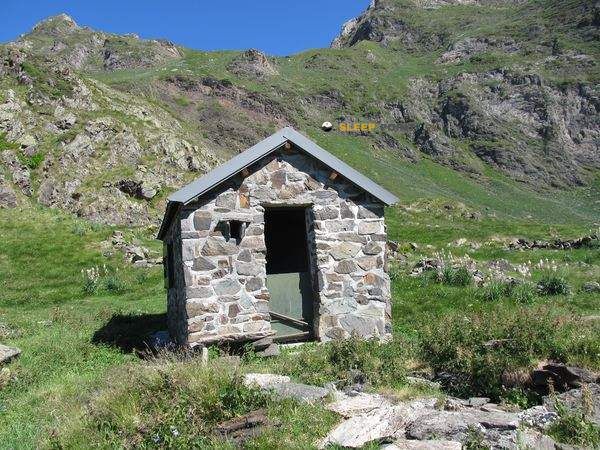
Mountain refuge Cabane des Toucouets
We have it listed in the app!
We have it listed in the app!


Protected by the wild surroundings of cabanes de toucouets, sers, argelès-gazost, altos pirineos, occitania, francia metropolitana, 65120, francia, the Cabane des Toucouets refuge is your best ally at 1738 meters of elevation. Once you reach its coordinates (42.913, 0.049), you can enjoy a well-deserved mountain rest.
8.9°C
Feels like: 6.4°C5.6 km/h
Gusts: 4.7 km/h4330 m
Snow lineUV 0
Clouds: 9% 11.4 mm
 15.5 km/h
 UV máx: 2.9
 06:22
06:22
 21:33
0 mm
6.8 km/h
UV máx: 6.8
06:22
21:34
0.1 mm
10.4 km/h
UV máx: 7.5
06:21
21:35
0 mm
11.6 km/h
UV máx: 7.9
06:21
21:36
3.9 mm
9.9 km/h
UV máx: 8.05
06:21
21:36
0 mm
7.6 km/h
UV máx: 2.3
06:20
21:37
0.6 mm
8.6 km/h
UV máx: 7.7
06:20
21:37
21:33
0 mm
6.8 km/h
UV máx: 6.8
06:22
21:34
0.1 mm
10.4 km/h
UV máx: 7.5
06:21
21:35
0 mm
11.6 km/h
UV máx: 7.9
06:21
21:36
3.9 mm
9.9 km/h
UV máx: 8.05
06:21
21:36
0 mm
7.6 km/h
UV máx: 2.3
06:20
21:37
0.6 mm
8.6 km/h
UV máx: 7.7
06:20
21:37
It is appropriate to go out with the water well solved. In the Cabane des Toucouets At 1738 metres, the nearest registered sources are more than 2 kilometres away, so it is not wise to have immediate supply next to the shelter. On a long day, with changing weather or if it is late, this detail weighs as much as the direction of the itinerary itself and forces to plan with margin.
The environment has a clearly pyrenees character, in the area of Sers within the French Pyrenees and in the area of access to very busy sectors of the massif. The closeness of tops as Pène Det Pouri , Pic de Lévas , Soum de Nére or Pic d'Ayré place this cabin in a relief of high slopes, crests and steps where the terrain can change quickly according to the fog, wind or time of year.
More than an isolated destination, it works as a support in a network of mountain tours. By its position it fits into exits towards the Pic de Bergons , Col de Pierrefitte or the Lac de Peyrelade , and can also make sense within longer routes linked to GR 10F and to the Pyrenees. When the day is long, tiredness or foresight gets worse, having a mountain shelter at this point can help to divide stage or not force a descent.
The practical reading of the place goes by giving nothing of course: in high and half mountain pirenaica, 1738 meters already involve exposure to time change, irregular visibility and cold nights out of season. If it is proposed as part of a road planning, it is appropriate to review the state of the itinerary, to carry sufficient autonomy and to consider the cabin as a logistical resource rather than as a final tour.


Download the app and start looking for the shelter of your next adventure


Find a place to sleep before night falls.