Mountain refuge Cabane de Caillong

We have it listed in the app!


            Mountain refuge Cabane de Caillong in route forestière, le pla, foix, ariège, occitania, francia metropolitana, 09460, francia
Five orange stars in a horizontal row representing a five-star rating.

Cabane de Caillong

Lat: 42.706xxx – Lon: 2.056xxx
📍 route forestière, le pla, foix, ariège, occitania, francia metropolitana, 09460, francia
Cabane de Caillong

Prepare your backpack and head to route forestière, le pla, foix, ariège, occitania, francia metropolitana, 09460, francia. There you will find the Cabane de Caillong refuge at 1491 meters of elevation. An essential stop along the way (Lat: 42.706, Lon: 2.056) for any mountain enthusiast.

See more
See more
Usuario

Lucas Martinez

Premium user

Live weather: Cabane de Caillong

Alpine weather summary for Cabane de Caillong: temperature at 10.4°C, feels like 9.9°C. Wind at 2.6 km/h with peaks of 5.4 km/h. UV index at 0 and freezing altitude at 4480 m. Maximum temperatures of 17.8°C in the coming hours.
Temperature

10.4°C

Feels like: 9.9°C
Wind

2.6 km/h

Gusts: 5.4 km/h
Freezing level 0°

4480 m

Snow line
Sky & UV

UV 0

Clouds: 100%

Next 48 hours evolution

7-day forecast

04/06
17.8° 6.4°
12.8 mm 16.4 km/h UV máx: 5
06:15 21:25
05/06
11.3° 4.4°
0.4 mm 14.8 km/h UV máx: 7.65
06:14 21:25
06/06
17.4° 6.8°
0.5 mm 13.8 km/h UV máx: 6.9
06:14 21:26
07/06
21° 9.6°
2.67 mm 10 km/h UV máx: 7.1
06:14 21:27
08/06
16.3° 8.9°
5.4 mm 12 km/h UV máx: 7.9
06:13 21:27
09/06
11.1° 5.8°
0.6 mm 15.2 km/h UV máx: 3.25
06:13 21:28
10/06
17.1° 4.7°
1.2 mm 7.7 km/h UV máx: 7.7
06:13 21:29

Between Le Pla and the steps of Caprir

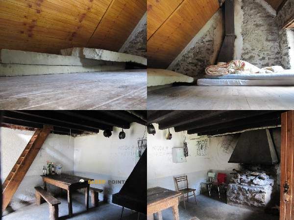
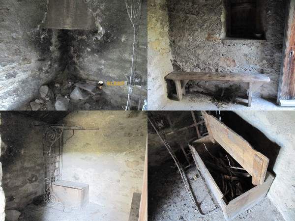
In the field of Le Pla in the more eastern Ariège, the relief begins to be closed on forest and dorsal slopes that announce the transition to more open and higher land. In this context the Cabane de Caillong , within a useful space for those who move on the northern side of the steps that connect with the Capcir and the surroundings of the Portella Blanca d'Andorra. It is not an isolated refuge of any transit: through this area they pass long-range traces like the GR 7 , in addition to Chemin Vauban and senderist variants that articulate the advance between hills, forests and mountain loins.

Practical reading of access

The reference of a forest track in the environment helps to understand its position: it is not a cabin placed in a remote glacier circus, but a mountain support in the middle, at 1,491 meters, where access can combine comfortable approach with sections that already require direction and reading of the land according to the chosen route. For whom the GR 7 , can make sense as a point of guard or day reorganisation if conditions change, especially on long routes where a small deviation compensates against exposure in collars or more open areas. It also fits into local routes such as PR31 Les rhododendrons , although its main role seems more linked to mountain traffic than to short walk.

The nearby landscape blends forest masses, secondary peaks and summits that already clearly exceed two thousand meters, such as Le Roc Blanc or Pic de Monpudou , which gives an idea of the nature of the environment and the speed with which meteorology can change by gaining height. It is not appropriate to have immediate water in the same cabin: the nearest invented sources are more than 2.5 km away, so it is reasonable to go out with sufficient autonomy and check the itinerary well before relying on the shelter as the only logistical support.

Hiking routes from the refuge

Local

Chemin Vauban

↔ Variable distance
GR 7

Des Vosges aux Pyrénées 13, vers le Col de Tougnets

↔ Variable distance
GR 7

Des Vosges aux Pyrénées 14, Porte de Barboilliere - Portella Blanca d'Andorra

↔ Variable distance
7B

Des Vosges aux Pyrénées, variante

↔ Variable distance
PR31

Les rhododendrons

↔ 7 km
QR03

La Bruyante

↔ Variable distance
QR15

Étang du Laurenti

↔ Variable distance
AX33

Le Pic du Tarbesou

↔ Variable distance

Nearby peaks

Roc de la Couillade del Peyroulet

Altitude not available
Lat: 42.6661 Lon: 2.0916

Roc du Serrat de la Pastère

Altitude not available
Lat: 42.6646 Lon: 2.1006

Roc du Taillat del Bossut

Altitude not available
Lat: 42.6643 Lon: 2.0962

Puc de Pujeguère

1367 m
Lat: 42.7441 Lon: 2.1015

Le Roc Blanc

2542 m
Lat: 42.6715 Lon: 2.0075

Pic de Monpudou

2191 m
Lat: 42.7118 Lon: 1.9842

Canrusc

2132 m
Lat: 42.7126 Lon: 1.9995

Pic de Canras

2459 m
Lat: 42.669 Lon: 2.0042

Nearby water fountains

Fuente

2.62 Km
Lat: 42.669 Lon: 2.0042

Fuente

2.64 Km
Lat: 42.669 Lon: 2.0042

Fuente

2.91 Km
Lat: 42.669 Lon: 2.0042

Fuente

3.94 Km
Lat: 42.669 Lon: 2.0042

Fuente

5.76 Km
Lat: 42.669 Lon: 2.0042

Fuente

5.95 Km
Lat: 42.669 Lon: 2.0042

Fuente

6.02 Km
Lat: 42.669 Lon: 2.0042

Fuente

6.04 Km
Lat: 42.669 Lon: 2.0042
FAQ

Frequently asked questions

Pregunta frecuente
At what exact altitude is the Cabane de Caillong refuge located?
The Cabane de Caillong refuge is located at an altitude of 1491 meters above sea level, in the natural surroundings of route forestière, le pla, foix, ariège, occitania, francia metropolitana, 09460, francia.
Pregunta frecuente
What are the GPS coordinates of the Cabane de Caillong refuge?
To locate the Cabane de Caillong refuge on your GPS or map, use the following coordinates: Latitude 42.706 and Longitude 2.056.
Pregunta frecuente
Is it necessary to carry a GPS to reach the Cabane de Caillong refuge?
It is always highly recommended to carry a GPS device, a route track, or a topographic map in the mountains. You can use the coordinates 42.706, 2.056 to locate this refuge precisely.
More areas

Other areas

Collaborative

Together we improve

image

Send your photos

You can upload photos of shelters and update their status so other users know if they can go there.

Get started
Get started
image

Rate the shelter

Leave your comments to rate the shelter’s condition. In the mountains, we look after each other.

Get started
Get started
image

Add new ones

Did we miss any? Publish the shelters you know so everyone can use them.

Get started
Get started
Download for free from the Apple App Store and Play Store.

Download the app and start looking for the shelter of your next adventure

Aplicación móvil para encontrar refugios de montaña donde dormir
Aplicación móvil para encontrar refugios de montaña donde dormir.
Mapa interactivo de refugios de montaña en los Pirineos dentro de la app
Mapa de refugios de montaña para senderismo y trekking en la app.
Pantalla con información de refugio de montaña con altitud capacidad y servicios
Pantalla con información de refugio de montaña con altitud capacidad y servicios.
Detalles de refugio de montaña con servicios y meteorología en aplicación móvil
Detalles de refugio de montaña con servicios y meteorología en aplicación móvil.
Aplicación para explorar refugios de montaña mediante mapa interactivo
Aplicación para explorar refugios de montaña mediante mapa interactivo.
Ficha completa de refugio de montaña con opiniones y servicios
Ficha completa de refugio de montaña con opiniones y servicios.
Información detallada de refugio en app para montañeros
Información detallada de refugio en app para montañeros.
Listado de refugios de montaña para senderismo y trekking
Listado de refugios de montaña para senderismo y trekking.
Explorar refugios de montaña desde una aplicación móvil
Explorar refugios de montaña desde una aplicación móvil.