Mountain refuge Cabane de Auzut

We have it listed in the app!


            Mountain refuge Cabane de Auzut in cabane d auzut - ustou, route d'angouls, couflens, saint-girons, ariège, occitania, francia metropolitana, 09140, francia
Five orange stars in a horizontal row representing a five-star rating.

Cabane de Auzut

Lat: 42.774xxx – Lon: 1.168xxx
📍 cabane d auzut - ustou, route d'angouls, couflens, saint-girons, ariège, occitania, francia metropolitana, 09140, francia
Cabane de Auzut

Prepare your backpack and head to cabane d auzut - ustou, route d'angouls, couflens, saint-girons, ariège, occitania, francia metropolitana, 09140, francia. There you will find the Cabane de Auzut refuge at 1325 meters of elevation. An essential stop along the way (Lat: 42.774, Lon: 1.168) for any mountain enthusiast.

See more
See more
Usuario

Lucas Martinez

Premium user

Live weather: Cabane de Auzut

The current weather in Cabane de Auzut indicates a temperature of 11.5°C, although the 10.4 km/h wind makes it feel like 9.1°C. Watch out for gusts of 11.2 km/h. The snow altitude (freezing level 0°) is around 4430 m and today we will reach a high of 12.8°C.
Temperature

11.5°C

Feels like: 9.1°C
Wind

10.4 km/h

Gusts: 11.2 km/h
Freezing level 0°

4430 m

Snow line
Sky & UV

UV 0

Clouds: 100%

Next 48 hours evolution

7-day forecast

04/06
12.8° 6.8°
25.3 mm 12.4 km/h UV máx: 4.6
06:18 21:28
05/06
12° 3.3°
0 mm 10.5 km/h UV máx: 7.35
06:18 21:29
06/06
17.2° 7.1°
4.8 mm 12.1 km/h UV máx: 7.5
06:17 21:30
07/06
19.6° 8.1°
8.3 mm 7.6 km/h UV máx: 6.9
06:17 21:31
08/06
22.5° 12.4°
5.4 mm 10.3 km/h UV máx: 7.75
06:17 21:31
09/06
11.8°
7.2 mm 9.3 km/h UV máx: 2.8
06:16 21:32
10/06
17.8° 6.7°
0.6 mm 10 km/h UV máx: 7.65
06:16 21:32

At the axis of the Port of Salau

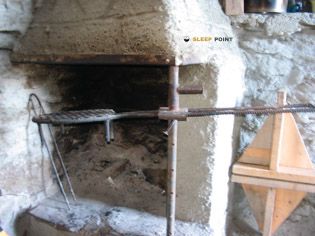
The Cabane de Auzut the logic of the passage of the Port of Salau and the stages of the HRP and GR 10 that cross this sector of the Ariège. At 1325 metres, in the surroundings of Auzut and Couflens, it works mainly as a mountain shelter to divide days into a Pyrenees valley where the orientation of the terrain and the continuity of the itineraries matter more than the proximity to inhabited cores.

The surrounding relief announces a clear transition between the bottom of the valley and the more serious mountain. To the surroundings are raised peaks such as the Pic de Montalt, the Pic de Fonta or the Tuc de Geu, visual reference of a land that gains height quickly and that can become more exposed to the wind and time changes as port or cordal is sought. It can also serve as a support for identified routes such as the TSO 55 towards the Coll de la Pala de Clavera or the TSO 56 towards Port d'Aulà, always understanding that useful distances depend on the exact point of access and the plan of crossing.

In planning, attention should be paid to water. The nearest registered source is about 2.6 km away, so it is not reasonable to have immediate supply next to the shelter without prior verification. In a long-passage border area, with changing meteorology and routes that can be extended according to the state of the path, the most sensible thing is to arrive with basic autonomy and sufficient margin to adapt the day.

Hiking routes from the refuge

HRP

HRP Étape 26

↔ Variable distance
HRP

HRP Étape 27

↔ Variable distance
Local

route du Port de Salau

↔ Variable distance
GR 10

La traversée des Pyrénées - sec.4

↔ Variable distance
GRT 55

Pont de Pedrosa al Coll de la Pala de Clavera

↔ 6.6 km
GRT 56

Pont de Pedrosa al Port d'Aulà

↔ 4.5 km
GRT 57

Refugi del Fornet al Port de Salau

↔ 4.200 km

Nearby peaks

Pic de Bassiero

2543.8 m
Lat: 42.7243 Lon: 1.1405

Tuc de Geu

2499 m
Lat: 42.7289 Lon: 1.1332

Pic de Montalt

2494.9 m
Lat: 42.7503 Lon: 1.1328

Tuc de Peyre Mensongèro

1711 m
Lat: 42.7978 Lon: 1.2262

Pic de Fonta

1934 m
Lat: 42.8045 Lon: 1.1583

Pic de la Tèse

2254 m
Lat: 42.7615 Lon: 1.2265

Tuc de Portavera

2255.5 m
Lat: 42.7426 Lon: 1.1312

Tuc dera Peguilha

2266 m
Lat: 42.736 Lon: 1.135

Nearby water fountains

Fuente

2.64 Km
Lat: 42.736 Lon: 1.135

Fuente

3.09 Km
Lat: 42.736 Lon: 1.135

Fuente

5.41 Km
Lat: 42.736 Lon: 1.135

Fuente

6.78 Km
Lat: 42.736 Lon: 1.135

Fuente

6.96 Km
Lat: 42.736 Lon: 1.135

Fuente

7.51 Km
Lat: 42.736 Lon: 1.135

Fuente

7.88 Km
Lat: 42.736 Lon: 1.135

Fuente

8.22 Km
Lat: 42.736 Lon: 1.135
FAQ

Frequently asked questions

Pregunta frecuente
At what exact altitude is the Cabane de Auzut refuge located?
The Cabane de Auzut refuge is located at an altitude of 1325 meters above sea level, in the natural surroundings of cabane d auzut - ustou, route d'angouls, couflens, saint-girons, ariège, occitania, francia metropolitana, 09140, francia.
Pregunta frecuente
What are the GPS coordinates of the Cabane de Auzut refuge?
To locate the Cabane de Auzut refuge on your GPS or map, use the following coordinates: Latitude 42.774 and Longitude 1.168.
Pregunta frecuente
Is it necessary to carry a GPS to reach the Cabane de Auzut refuge?
It is always highly recommended to carry a GPS device, a route track, or a topographic map in the mountains. You can use the coordinates 42.774, 1.168 to locate this refuge precisely.
More areas

Other areas

Collaborative

Together we improve

image

Send your photos

You can upload photos of shelters and update their status so other users know if they can go there.

Get started
Get started
image

Rate the shelter

Leave your comments to rate the shelter’s condition. In the mountains, we look after each other.

Get started
Get started
image

Add new ones

Did we miss any? Publish the shelters you know so everyone can use them.

Get started
Get started
Download for free from the Apple App Store and Play Store.

Download the app and start looking for the shelter of your next adventure

Aplicación móvil para encontrar refugios de montaña donde dormir
Aplicación móvil para encontrar refugios de montaña donde dormir.
Mapa interactivo de refugios de montaña en los Pirineos dentro de la app
Mapa de refugios de montaña para senderismo y trekking en la app.
Pantalla con información de refugio de montaña con altitud capacidad y servicios
Pantalla con información de refugio de montaña con altitud capacidad y servicios.
Detalles de refugio de montaña con servicios y meteorología en aplicación móvil
Detalles de refugio de montaña con servicios y meteorología en aplicación móvil.
Aplicación para explorar refugios de montaña mediante mapa interactivo
Aplicación para explorar refugios de montaña mediante mapa interactivo.
Ficha completa de refugio de montaña con opiniones y servicios
Ficha completa de refugio de montaña con opiniones y servicios.
Información detallada de refugio en app para montañeros
Información detallada de refugio en app para montañeros.
Listado de refugios de montaña para senderismo y trekking
Listado de refugios de montaña para senderismo y trekking.
Explorar refugios de montaña desde una aplicación móvil
Explorar refugios de montaña desde una aplicación móvil.