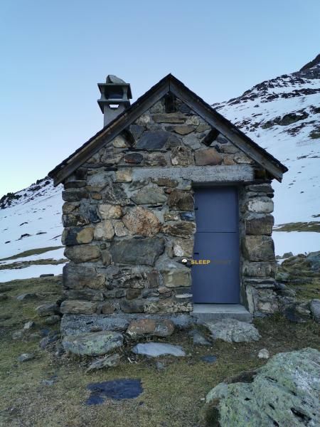
Mountain refuge Cabane d'Alans
We have it listed in the app!
We have it listed in the app!


Protected by the wild surroundings of cabane d'alans, sentier des balcons, gavarnie, gavarnie-gèdre, argelès-gazost, altos pirineos, occitania, francia metropolitana, 65120, francia, the Cabane d'Alans refuge is your best ally at 1905 meters of elevation. Once you reach its coordinates (42.73, 0.004), you can enjoy a well-deserved mountain rest.
11.3°C
Feels like: 7.7°C14.4 km/h
Gusts: 34.2 km/h4370 m
Snow lineUV 0
Clouds: 47% 11.6 mm
 14.4 km/h
 UV máx: 5.7
 06:23
06:23
 21:33
0 mm
8.4 km/h
UV máx: 8.1
06:22
21:34
0 mm
7.4 km/h
UV máx: 7.7
06:22
21:34
0 mm
9 km/h
UV máx: 8.1
06:22
21:35
0 mm
16.8 km/h
UV máx: 8.25
06:21
21:36
1.8 mm
10.8 km/h
UV máx: 7.85
06:21
21:36
0 mm
11.9 km/h
UV máx: 7.9
06:21
21:37
21:33
0 mm
8.4 km/h
UV máx: 8.1
06:22
21:34
0 mm
7.4 km/h
UV máx: 7.7
06:22
21:34
0 mm
9 km/h
UV máx: 8.1
06:22
21:35
0 mm
16.8 km/h
UV máx: 8.25
06:21
21:36
1.8 mm
10.8 km/h
UV máx: 7.85
06:21
21:36
0 mm
11.9 km/h
UV máx: 7.9
06:21
21:37
Cabane d'Alans at 1905 meters in the environment of Gavarnie-Gèdre , is located on an elevated slope that functions as a natural balcony on the great glacial landscape of the area. The open land, with high pastures and pirenaic minerality, leaves a sense of wide and exposed mountain, very different from the shelters in the forest. Its position is particularly interesting for those who look for a night in height with views and quick access to travel routes.
The approach moves in the atmosphere of a classic mountain path, with a sustained delevel and sections where the sun, wind or a sudden change of time can be noticed. It does not seem like an enclave for an improvised walk: it is necessary to arrive with regular rhythm, sufficient water and time range. Although there are several sources within a radius of approximately 1 to 1.5 km, it is not always interested to trust all the day to points that may be left outside the immediate itinerary, so it is worth securing the load before the final rise.
As a base camp, the cabin fits very well to link stages of the HRP , especially between stages 15, 16 and 17, or to move towards Cirque de Gavarnie and Col le Pourteillou . It also opens mountain options towards nearby summits: Pimené it rises to just 1.55 km in a straight line and dominates the sector with a highly recognizable silhouette; further there are objectives of greater entity such as the Grand Astazou , Marboré Cylinder or Le Casque du Marboré , already in a much more alpine and demanding terrain.
The environment combines passage and feeling of isolation. It is not lost in an inaccessible corner, because there are well-known routes around here, but as the afternoon falls it continues to offer that high mountain environment where the orientation with respect to hills and crests matters. From this point of view the transition between the large pirenaic circles and the lines that seek the border divide is well understood, a very useful location for mountaineers who prioritize strategy and terrain over comfort.


📏 0 Km
⛰️ 1904 m

📏 1.2 Km
⛰️ 1748 m

📏 1.2 Km
⛰️ 1750 m

📏 1.3 Km
⛰️ 2027 m

📏 1.3 Km
⛰️ 1850 m

📏 2.1 Km
⛰️ 1800 m

📏 2.4 Km
⛰️ 1495 m

📏 2.4 Km
⛰️ 1500 m
Download the app and start looking for the shelter of your next adventure


Find a place to sleep before night falls.


