Mountain refuge Cabane Cums

We have it listed in the app!


            Mountain refuge Cabane Cums in cabane cums, route forestière de mariailles, casteil, prades, pirineos orientales, occitania, francia metropolitana, 66820, francia
Five orange stars in a horizontal row representing a five-star rating.

Cabane Cums

Lat: 42.459xxx – Lon: 2.425xxx
📍 cabane cums, route forestière de mariailles, casteil, prades, pirineos orientales, occitania, francia metropolitana, 66820, francia
Cabane Cums

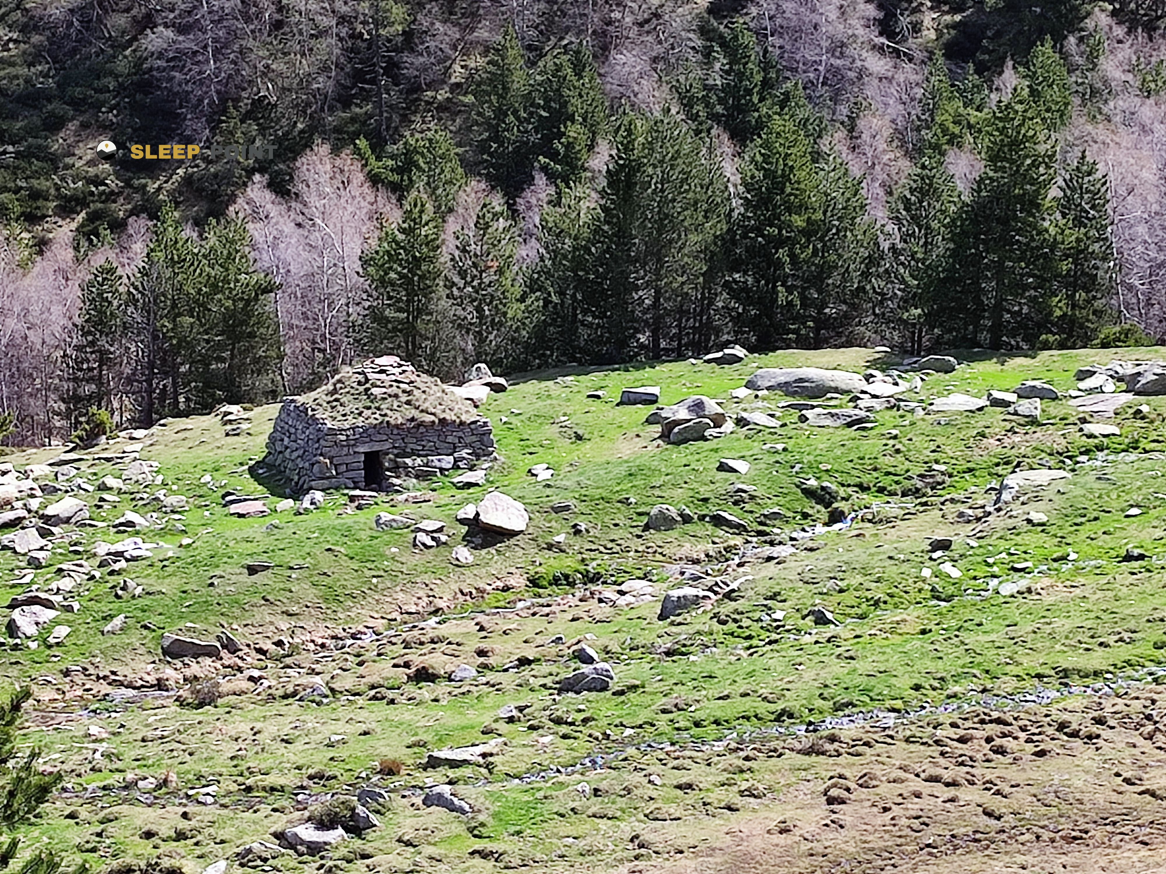
If you are planning a route through cabane cums, route forestière de mariailles, casteil, prades, pirineos orientales, occitania, francia metropolitana, 66820, francia, the Cabane Cums refuge is a must-stop. Located at 1865 m above sea level, it offers hikers and climbers a safe place to regain strength. Save its coordinates (42.459, 2.425) in your GPS to stay on course during your journey.

See more
See more
Usuario

Lucas Martinez

Premium user

Live weather: Cabane Cums

The current weather in Cabane Cums indicates a temperature of 7.1°C, although the 1.9 km/h wind makes it feel like 5°C. Watch out for gusts of 2.5 km/h. The snow altitude (freezing level 0°) is around 4410 m and today we will reach a high of 14.6°C.
Temperature

7.1°C

Feels like: 5°C
Wind

1.9 km/h

Gusts: 2.5 km/h
Freezing level 0°

4410 m

Snow line
Sky & UV

UV 0

Clouds: 19%

Next 48 hours evolution

7-day forecast

04/06
14.6° 5.6°
20.8 mm 33.7 km/h UV máx: 6.55
06:14 21:22
05/06
7.4° 3.1°
0.7 mm 32.5 km/h UV máx: 6.05
06:14 21:23
06/06
15.3° 6.6°
0.08 mm 8 km/h UV máx: 6.4
06:13 21:24
07/06
17.6° 7.7°
2.6 mm 6.5 km/h UV máx: 7.5
06:13 21:24
08/06
19.1° 9.2°
2.4 mm 8.8 km/h UV máx: 7.65
06:13 21:25
09/06
14° 7.3°
12.9 mm 12.2 km/h UV máx: 4.2
06:12 21:26
10/06
14.5° 7.1°
0.9 mm 6.6 km/h UV máx: 7.75
06:12 21:26

Under the line of Pic des Sept Hommes and the crest that articulates this sector of Cannigó , Cabane Cums is left in a strip of medium-high mountain where the relief begins to gain alpine character without losing entirely the relationship with the slopes and forests of the surroundings of Mariailles and Casteil. At 1,865 meters, its position fits better as a walking coat than as a simple isolated destination: it is within a very used area for linking long routes, with the HRP and GR 10 in the near context, in addition to Tour del Canigó A classic round around the massif. This combination places it on a useful ground to divide days, adjust stages, or seek an alternative to guard on a journey through the Conflent.

The practical reading of the place forces you to think about autonomy. There are no water points near the shelter and the registered sources are several kilometres away, so it is appropriate to leave with the solved supply and not to take for granted that it can be filled by. It is also interesting to anticipate changing weather and mountain orientation, because the sector links loops, roseys and secondary crest such as the Roc del Cim des Cums or the Roc dels Lladres, and can be hardened with fog, wind or bad visibility. From this cabane, more than a comfortable base of services, it is reasonable to understand a simple support within the massif, well located to continue towards the long-range pirenaic stages or to move through the network of steps surrounding the Cannigó.

Hiking routes from the refuge

GR 83

Camí del nord o del Canigó

↔ 201.77 km
GR 151

Camí Oliba

↔ 239.54 km
HRP

HRP Étape 36

↔ Variable distance
HRP

HRP Étape 37

↔ Variable distance
GR 10

La traversée des Pyrénées - sec.2

↔ Variable distance
Tour del Canigó

Tour del Canigó

↔ 63 km
Local

Camins de l'exili

↔ 60 km
Local

Refugis del Torb

↔ 78 km

Nearby peaks

Pic des Sept Hommes

2651 m
Lat: 42.4848 Lon: 2.4396

Puig del Roc Negre

2714 m
Lat: 42.5001 Lon: 2.4712

Roc de la Roquette

Altitude not available
Lat: 42.4783 Lon: 2.4097

Roc del Cim des Cums

Altitude not available
Lat: 42.467 Lon: 2.4192

Roc dels Lladres

Altitude not available
Lat: 42.4694 Lon: 2.4113

Crête des Sept Hommes

Altitude not available
Lat: 42.4906 Lon: 2.4321

Pic de Bassibès

2637 m
Lat: 42.4845 Lon: 2.447

Pic de Soule de Ramounet

Altitude not available
Lat: 42.5074 Lon: 2.4041

Nearby water fountains

Fuente

7.34 Km
Lat: 42.5074 Lon: 2.4041

Font de la Placeta

7.36 Km
Lat: 42.5074 Lon: 2.4041

Fuente

7.36 Km
Lat: 42.5074 Lon: 2.4041

Fuente

7.4 Km
Lat: 42.5074 Lon: 2.4041

Font de l'esglesia

7.45 Km
Lat: 42.5074 Lon: 2.4041

Fuente

7.6 Km
Lat: 42.5074 Lon: 2.4041

Fuente

8.59 Km
Lat: 42.5074 Lon: 2.4041

Fuente

9.05 Km
Lat: 42.5074 Lon: 2.4041
FAQ

Frequently asked questions

Pregunta frecuente
Is it necessary to carry a GPS to reach the Cabane Cums refuge?
It is always highly recommended to carry a GPS device, a route track, or a topographic map in the mountains. You can use the coordinates 42.459, 2.425 to locate this refuge precisely.
Pregunta frecuente
In which municipality or region is the Cabane Cums refuge located?
This refuge is located within the municipality of Casteil, belonging to the community or region of Occitania.
Pregunta frecuente
Are there other mountain refuges near Cabane Cums?
Yes, nearby you can find other options to spend the night or take shelter. El refugio más próximo es el Cabane des Cums, que se encuentra a aproximadamente 0 km de distancia.
More areas

Other areas

Collaborative

Together we improve

image

Send your photos

You can upload photos of shelters and update their status so other users know if they can go there.

Get started
Get started
image

Rate the shelter

Leave your comments to rate the shelter’s condition. In the mountains, we look after each other.

Get started
Get started
image

Add new ones

Did we miss any? Publish the shelters you know so everyone can use them.

Get started
Get started
Download for free from the Apple App Store and Play Store.

Download the app and start looking for the shelter of your next adventure

Aplicación móvil para encontrar refugios de montaña donde dormir
Aplicación móvil para encontrar refugios de montaña donde dormir.
Mapa interactivo de refugios de montaña en los Pirineos dentro de la app
Mapa de refugios de montaña para senderismo y trekking en la app.
Pantalla con información de refugio de montaña con altitud capacidad y servicios
Pantalla con información de refugio de montaña con altitud capacidad y servicios.
Detalles de refugio de montaña con servicios y meteorología en aplicación móvil
Detalles de refugio de montaña con servicios y meteorología en aplicación móvil.
Aplicación para explorar refugios de montaña mediante mapa interactivo
Aplicación para explorar refugios de montaña mediante mapa interactivo.
Ficha completa de refugio de montaña con opiniones y servicios
Ficha completa de refugio de montaña con opiniones y servicios.
Información detallada de refugio en app para montañeros
Información detallada de refugio en app para montañeros.
Listado de refugios de montaña para senderismo y trekking
Listado de refugios de montaña para senderismo y trekking.
Explorar refugios de montaña desde una aplicación móvil
Explorar refugios de montaña desde una aplicación móvil.