Mountain refuge Bivacco Giorgio Casalegno

We have it listed in the app!


            Mountain refuge Bivacco Giorgio Casalegno in bivacco giorgio casalegno, strada del valle argentera, sauze di cesana, turín, piamonte, italia
Five orange stars in a horizontal row representing a five-star rating.

Bivacco Giorgio Casalegno

Lat: 44.855xxx – Lon: 6.962xxx
📍 bivacco giorgio casalegno, strada del valle argentera, sauze di cesana, turín, piamonte, italia
Bivacco Giorgio Casalegno

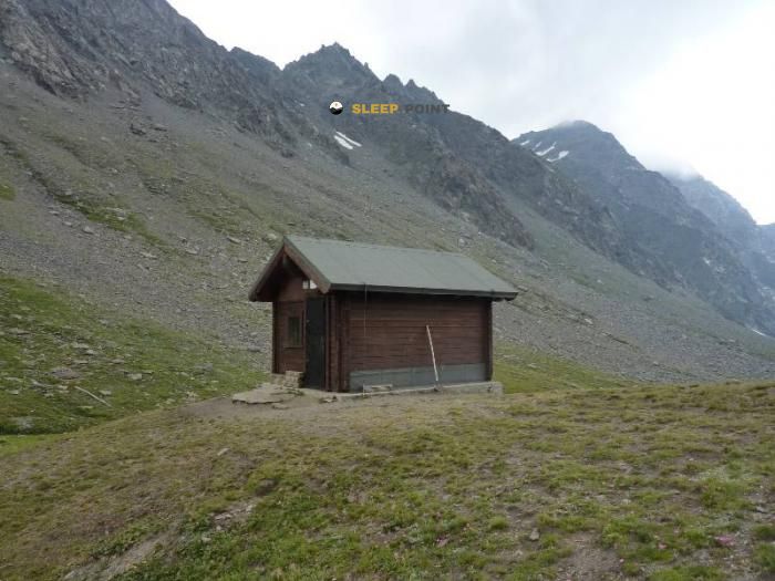
Located in the heart of bivacco giorgio casalegno, strada del valle argentera, sauze di cesana, turín, piamonte, italia, the Bivacco Giorgio Casalegno refuge offers shelter at 2515 meters above sea level. Ideal for trekking and nature lovers, this mountain shelter (Lat: 44.855, Lon: 6.962) is the perfect starting point or resting place for local routes.

See more
See more
Usuario

Lucas Martinez

Premium user

Live weather: Bivacco Giorgio Casalegno

If you plan to go up today to 2515 m at Bivacco Giorgio Casalegno, you will find 6.1°C with a feels-like temperature of 2.8°C. The freezing level is at 4150 m. The forecast shows steady winds of 3.1 km/h and peaks of 26.3 km/h. A high of 11.4°C is expected.
Temperature

6.1°C

Feels like: 2.8°C
Wind

3.1 km/h

Gusts: 26.3 km/h
Freezing level 0°

4150 m

Snow line
Sky & UV

UV 0

Clouds: 100%

Next 48 hours evolution

7-day forecast

04/06
11.4°
16.3 mm 27.7 km/h UV máx: 7.15
05:47 21:13
05/06
9.6° -0°
0.7 mm 15.3 km/h UV máx: 7.8
05:47 21:14
06/06
12.2° 3.5°
0 mm 23.4 km/h UV máx: 7.7
05:46 21:14
07/06
13.9° 3.9°
2.4 mm 8.6 km/h UV máx: 8.05
05:46 21:15
08/06
13.7° 6.1°
0.75 mm 23.3 km/h UV máx: 7.75
05:46 21:16
09/06
13.6° 5.2°
0 mm 13.8 km/h UV máx: 6.95
05:46 21:16
10/06
9.6° 2.4°
0 mm 13.4 km/h UV máx: 7.05
05:45 21:17

Bivacco Giorgio Casalegno is located at the end of Sauze di Cesana, in the Piedmont, 2515 meters and very close to the border between Italy and the French Alps. With these data we can already plan the essential: it is a height support in an open mountain sector, with clearly alpine highlights and close references that help to read the ground, such as the Pic Charbonnel , just above the bivac, and more powerful summits around like Bric Froid / Punta Ramière or Grand Queyron .

Its position fits better into a logic of crossing or linking than the one of immediate passage shelter next to a valley background. The proximity of stages of the Via Alpina and the regional connection with long routes such as the Tour du Queyras or the GRV place it in an area where mountain traffic exists, but without losing isolated character. For those who study the map, this means assessing well whether it compensates to deviate to the bivac according to the intended route, the meteorology and the real need to break day in height.

The environment points to a typical transition of border mountain: approaches that can start on more friendly terrain and then win more nude slopes, peders and high areas under peaks and secondary peaks. The nearby presence of mountains such as Cima Frappier or Pointe Rasin reinforces this idea of varied terrain, where the orientation matters most as you leave the valley and enter into heights exposed to the wind and rapid changes of time.

In the logistics it is necessary to be prudent with the water. The registered sources are more than 3 kilometres away and therefore no immediate supply should be available next to the shelter. In an area of this altitude and with this degree of isolation, it makes sense to reach with sufficient autonomy and to review before departure the state of the itinerary and the conditions of the mountain.

Hiking routes from the refuge

GRV

Sulle strade dei valdesi: GRV Glorioso Rimpatrio dei Valdesi

↔ 325 km
GR 58

Tour du Queyras

↔ 108 km
Local

PR Étang de Moussou

↔ Variable distance
VA-D40

Via Alpina Blue D40

↔ 15.86 km
VA-D41

Via Alpina Blue D41

↔ 9.3 km
VA-D42

Via Alpina Blue D42

↔ 9.1 km
VA-D43

Via Alpina Blue D43

↔ 12.44 km
Local

Col de Rasis - Col des Thures

↔ Variable distance

Nearby peaks

Pic Charbonnel

2889 m
Lat: 44.8469 Lon: 6.9697

Bric Froid / Punta Ramière

3302 m
Lat: 44.8644 Lon: 6.9314

Gran Queyron / Grand Queyron

3060 m
Lat: 44.8424 Lon: 7.0013

Cima Frappier

3003 m
Lat: 44.8523 Lon: 7.0077

Gran Guglia

2819 m
Lat: 44.8324 Lon: 7.0278

Pointe Rasin

2974 m
Lat: 44.8399 Lon: 7.0066

Pic de Clausis

2915 m
Lat: 44.8354 Lon: 6.9106

Monte Barifreddo

3028 m
Lat: 44.8984 Lon: 6.988

Nearby water fountains

Fuente

3.43 Km
Lat: 44.8984 Lon: 6.988

Fuente

4.07 Km
Lat: 44.8984 Lon: 6.988

Fuente

4.14 Km
Lat: 44.8984 Lon: 6.988

Fuente

4.83 Km
Lat: 44.8984 Lon: 6.988

Fuente

4.84 Km
Lat: 44.8984 Lon: 6.988

Fuente

4.93 Km
Lat: 44.8984 Lon: 6.988

Fuente

5.51 Km
Lat: 44.8984 Lon: 6.988

Fuente

5.51 Km
Lat: 44.8984 Lon: 6.988
FAQ

Frequently asked questions

Pregunta frecuente
Is it necessary to carry a GPS to reach the Bivacco Giorgio Casalegno refuge?
It is always highly recommended to carry a GPS device, a route track, or a topographic map in the mountains. You can use the coordinates 44.855, 6.962 to locate this refuge precisely.
Pregunta frecuente
In which municipality or region is the Bivacco Giorgio Casalegno refuge located?
This refuge is located within the municipality of Sauze di Cesana, belonging to the community or region of Piamonte.
Pregunta frecuente
Are there other mountain refuges near Bivacco Giorgio Casalegno?
Yes, nearby you can find other options to spend the night or take shelter. El refugio más próximo es el Refuge Agritouristique Alpe Plane, que se encuentra a aproximadamente 3.6 km de distancia.
More areas

Other areas

Collaborative

Together we improve

image

Send your photos

You can upload photos of shelters and update their status so other users know if they can go there.

Get started
Get started
image

Rate the shelter

Leave your comments to rate the shelter’s condition. In the mountains, we look after each other.

Get started
Get started
image

Add new ones

Did we miss any? Publish the shelters you know so everyone can use them.

Get started
Get started
Download for free from the Apple App Store and Play Store.

Download the app and start looking for the shelter of your next adventure

Aplicación móvil para encontrar refugios de montaña donde dormir
Aplicación móvil para encontrar refugios de montaña donde dormir.
Mapa interactivo de refugios de montaña en los Pirineos dentro de la app
Mapa de refugios de montaña para senderismo y trekking en la app.
Pantalla con información de refugio de montaña con altitud capacidad y servicios
Pantalla con información de refugio de montaña con altitud capacidad y servicios.
Detalles de refugio de montaña con servicios y meteorología en aplicación móvil
Detalles de refugio de montaña con servicios y meteorología en aplicación móvil.
Aplicación para explorar refugios de montaña mediante mapa interactivo
Aplicación para explorar refugios de montaña mediante mapa interactivo.
Ficha completa de refugio de montaña con opiniones y servicios
Ficha completa de refugio de montaña con opiniones y servicios.
Información detallada de refugio en app para montañeros
Información detallada de refugio en app para montañeros.
Listado de refugios de montaña para senderismo y trekking
Listado de refugios de montaña para senderismo y trekking.
Explorar refugios de montaña desde una aplicación móvil
Explorar refugios de montaña desde una aplicación móvil.