Mountain refuge Bivacco Abele Traglio (bivacco Capezzone)
We have it listed in the app!
We have it listed in the app!


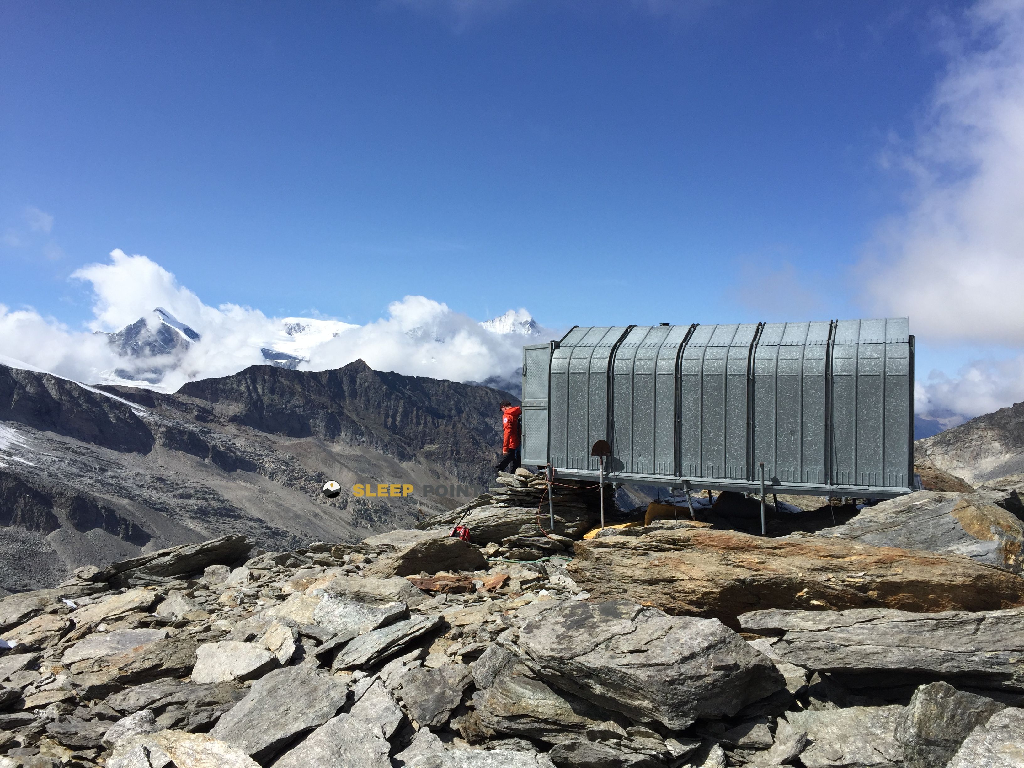
The Bivacco Abele Traglio (bivacco Capezzone) refuge acts as a base camp for the summits and routes of bivacco abele traglio, piazza guglianetti, campello monti / kampel, valstrona, verbano-cusio-ossola, piamonte, italia. At 2100 meters of elevation, its coordinates (45.938, 8.21) represent safety after a long day of effort.
7.6°C
Feels like: 4.5°C14.9 km/h
Gusts: 46.1 km/h3740 m
Snow lineUV 3.4
Clouds: 100% 17.4 mm
 17.8 km/h
 UV máx: 3.6
 05:38
05:38
 21:12
4.9 mm
14.8 km/h
UV máx: 7.75
05:38
21:13
7.32 mm
10.7 km/h
UV máx: 3.85
05:37
21:14
0.4 mm
5.2 km/h
UV máx: 6.5
05:37
21:14
3.6 mm
7.9 km/h
UV máx: 7.05
05:37
21:15
36.75 mm
9.6 km/h
UV máx: 6.15
05:36
21:16
0.3 mm
12.5 km/h
UV máx: 3.05
05:36
21:16
21:12
4.9 mm
14.8 km/h
UV máx: 7.75
05:38
21:13
7.32 mm
10.7 km/h
UV máx: 3.85
05:37
21:14
0.4 mm
5.2 km/h
UV máx: 6.5
05:37
21:14
3.6 mm
7.9 km/h
UV máx: 7.05
05:37
21:15
36.75 mm
9.6 km/h
UV máx: 6.15
05:36
21:16
0.3 mm
12.5 km/h
UV máx: 3.05
05:36
21:16
Mountain pass. That is the most useful reading of Bivacco Abele Traglio , also known as the Capezzone bivacco. At 2100 meters, in the term of Valstrona and within the Piedmont, it fits better as support to move between sides than as a simple isolated destination. Its position in the Cusiano Alps, in the south-east sector of the Peninos Alps, places it on a ground of crest, hills and open slopes where the day is decided by the orientation, time and continuity of the itinerary.
In this area they combine tours that help to understand their function. The GTA pass through stages such as Campello Monti - Rimella, Rimella - Alpe Baranca and Alpe Baranca - Carcophora, so that the shelter can serve to fail traverses or to link valleys on long itineraries. Local tracks such as Strà Vegia and Stra Granda also appear. It is not appropriate to read it only as a night point: its value is in how it allows to reorganize a hiking route in the area when it is sought to win a divisive, to change the basin or to prepare the continuation of the following day.
The near relief reinforces that character. The Cima di Capezzone is less than a kilometer and clearly marks the immediate alpine environment. Around there are also Monte Mora, Cima Cresta, Monte Capio and the Corno del Sole, summits that draw a compact mountain terrain, without large margins for improvisation if the visibility gets worse. Access and movements around the environment ask for physical form, custom of walking in height and attention to the map, especially if there is a journey between valleys.
In practical planning, water deserves a separate note. The nearest registered source is about 1.7 km away, and the rest are somewhat further away. This suggests not to take for granted an immediate supply next to the shelter and to leave with sufficient autonomy, especially on liaison days. At a point of passage like this, meteorology and logistics weigh as much as the gap.


📏 10.2 Km
⛰️ 1630 m

📏 16.5 Km
⛰️ 1720 m
📏 18.2 Km
⛰️ 3032 m

📏 19 Km
⛰️ 2782 m

📏 20.5 Km
⛰️ 2061 m

📏 20.8 Km
⛰️ 970 m

📏 21 Km
⛰️ 1820 m

📏 22.3 Km
⛰️ 1827 m
Download the app and start looking for the shelter of your next adventure


Find a place to sleep before night falls.


