Mountain refuge Bergeries de Teghia

We have it listed in the app!


            Mountain refuge Bergeries de Teghia in bergeries de teghia, d 84, corscia, corte, alta córcega, córcega, francia metropolitana, 20224, francia
Five orange stars in a horizontal row representing a five-star rating.

Bergeries de Teghia

Lat: 42.398xxx – Lon: 9.075xxx
📍 bergeries de teghia, d 84, corscia, corte, alta córcega, córcega, francia metropolitana, 20224, francia
Bergeries de Teghia

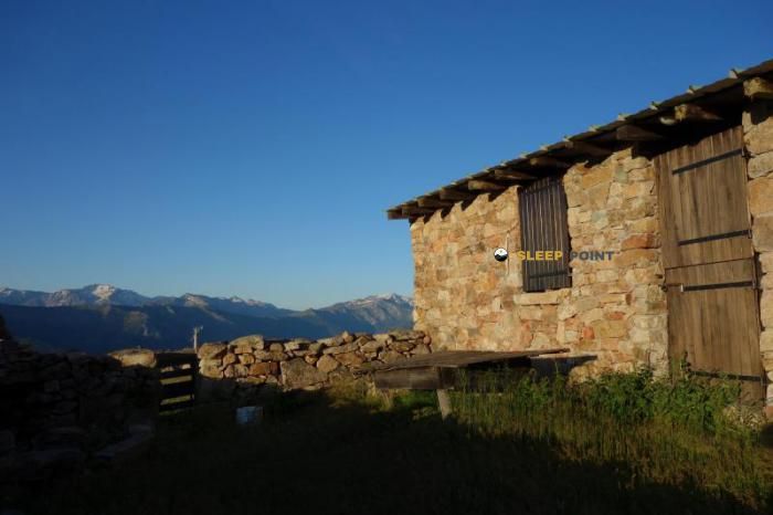
The Bergeries de Teghia refuge (bergeries de teghia, d 84, corscia, corte, alta córcega, córcega, francia metropolitana, 20224, francia) is a classic meeting point for mountaineers and hikers. At 1530 meters, its coordinates 42.398, 9.075 mark the end of a stage or the beginning of a new adventure.

See more
See more
Usuario

Lucas Martinez

Premium user

Live weather: Bergeries de Teghia

Before heading to Bergeries de Teghia, check the weather: we currently have 13.8°C (feels like 10.3°C). With wind gusts reaching 27 km/h and a freezing level around 4260 meters, the daytime high will not exceed 19.7°C.
Temperature

13.8°C

Feels like: 10.3°C
Wind

8.7 km/h

Gusts: 27 km/h
Freezing level 0°

4260 m

Snow line
Sky & UV

UV 1.65

Clouds: 91%

Next 48 hours evolution

7-day forecast

04/06
19.7° 10.7°
0 mm 13.4 km/h UV máx: 8.3
05:48 20:56
05/06
17.4° 10.1°
0 mm 21 km/h UV máx: 8.15
05:48 20:57
06/06
19.8° 8.2°
0 mm 10.1 km/h UV máx: 8.35
05:47 20:57
07/06
21.8° 12.1°
0 mm 11.9 km/h UV máx: 8.2
05:47 20:58
08/06
23° 13°
0 mm 10.9 km/h UV máx: 7.9
05:47 20:58
09/06
23.5° 15.1°
0 mm 12.3 km/h UV máx: 8
05:47 20:59
10/06
22.5° 15.2°
0 mm 13.6 km/h UV máx: 8
05:46 21:00

Base or step

In Bergeries de Teghia the difference between raising it as a basis of day or as a simple point of passage matters. On the one hand, it remains in the Corscia environment, next to the D84 axis and within the Alta Corsica mountain relief. On the other hand, its position fits well in walking through the area, such as the Sentier de la Transhumance or the Sentier de l'Altare, where it can be used to break a journey or to have an intermediate withdrawal.

The altitude, around 1530 meters, already places it at a level where time can change quickly. It's not a low-valley reference. The nearby terrain links with summits such as Capo di Lino, Dent d'Asco or Cima a i Mori, which gives a clear idea of the environment: marked mountain, nearby levels and itineraries that can be hardened if the day is complicated. More than just a place to extend the stay, it should be read as tactical support within a demanding day.

Autonomy and margin

This role of free refuge makes sense especially for those who prepare the effort well. If used as a basis, it is interesting to assess the real continuity of access and return, because the environment allows to link mountain terrain quickly. If used as an escape, its utility depends on arriving with physical and meteorological margin, not on haste times.

Water management should be prudent. The nearest source, Funtana Vignente, is about 2.7 km away, so no immediate supply should be taken for granted next to the shelter. In this area of Corsica it is more sensible to leave with sufficient autonomy and to confirm before the route both the state of the itinerary and the conditions of the time.

Hiking routes from the refuge

Local

Sentier de la Transhumance

↔ Variable distance
Local

Sentier de l'Altare

↔ Variable distance

Nearby peaks

Cima a i Mori

2180 m
Lat: 42.4208 Lon: 9.0806

Capo di Lino

1928 m
Lat: 42.4004 Lon: 9.0497

Pinzi a i Giuelli

1839 m
Lat: 42.4296 Lon: 9.1051

Punta Cavallare

1717 m
Lat: 42.4349 Lon: 9.1086

Turone

1927 m
Lat: 42.4283 Lon: 9.0983

Dent d'Asco

2064 m
Lat: 42.4285 Lon: 9.0779

Cima Laggiaro

1715 m
Lat: 42.4344 Lon: 9.0832

Capo Tubani

1453 m
Lat: 42.3804 Lon: 9.0556

Nearby water fountains

Funtana Vignente

2.71 Km
Lat: 42.3804 Lon: 9.0556

Fuente

4.87 Km
Lat: 42.3804 Lon: 9.0556

Fuente

5.56 Km
Lat: 42.3804 Lon: 9.0556

Fuente

6.98 Km
Lat: 42.3804 Lon: 9.0556

Fuente

7.12 Km
Lat: 42.3804 Lon: 9.0556

Fuente

7.7 Km
Lat: 42.3804 Lon: 9.0556

Fuente

8.3 Km
Lat: 42.3804 Lon: 9.0556

Fuente

8.53 Km
Lat: 42.3804 Lon: 9.0556
FAQ

Frequently asked questions

Pregunta frecuente
What are the GPS coordinates of the Bergeries de Teghia refuge?
To locate the Bergeries de Teghia refuge on your GPS or map, use the following coordinates: Latitude 42.398 and Longitude 9.075.
Pregunta frecuente
Is it necessary to carry a GPS to reach the Bergeries de Teghia refuge?
It is always highly recommended to carry a GPS device, a route track, or a topographic map in the mountains. You can use the coordinates 42.398, 9.075 to locate this refuge precisely.
Pregunta frecuente
In which municipality or region is the Bergeries de Teghia refuge located?
This refuge is located within the municipality of Corscia, belonging to the community or region of Córcega.
More areas

Other areas

Collaborative

Together we improve

image

Send your photos

You can upload photos of shelters and update their status so other users know if they can go there.

Get started
Get started
image

Rate the shelter

Leave your comments to rate the shelter’s condition. In the mountains, we look after each other.

Get started
Get started
image

Add new ones

Did we miss any? Publish the shelters you know so everyone can use them.

Get started
Get started
Download for free from the Apple App Store and Play Store.

Download the app and start looking for the shelter of your next adventure

Aplicación móvil para encontrar refugios de montaña donde dormir
Aplicación móvil para encontrar refugios de montaña donde dormir.
Mapa interactivo de refugios de montaña en los Pirineos dentro de la app
Mapa de refugios de montaña para senderismo y trekking en la app.
Pantalla con información de refugio de montaña con altitud capacidad y servicios
Pantalla con información de refugio de montaña con altitud capacidad y servicios.
Detalles de refugio de montaña con servicios y meteorología en aplicación móvil
Detalles de refugio de montaña con servicios y meteorología en aplicación móvil.
Aplicación para explorar refugios de montaña mediante mapa interactivo
Aplicación para explorar refugios de montaña mediante mapa interactivo.
Ficha completa de refugio de montaña con opiniones y servicios
Ficha completa de refugio de montaña con opiniones y servicios.
Información detallada de refugio en app para montañeros
Información detallada de refugio en app para montañeros.
Listado de refugios de montaña para senderismo y trekking
Listado de refugios de montaña para senderismo y trekking.
Explorar refugios de montaña desde una aplicación móvil
Explorar refugios de montaña desde una aplicación móvil.