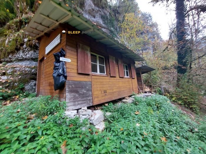
Mountain refuge Abri du Torret
We have it listed in the app!
We have it listed in the app!


Protected by the wild surroundings of sentier de la côte, grand'combe-des-bois, pontarlier, doubs, borgoña-franco condado, francia metropolitana, 25210, francia, the Abri du Torret refuge is your best ally at 650 meters of elevation. Once you reach its coordinates (47.122, 6.77), you can enjoy a well-deserved mountain rest.
12.2°C
Feels like: 10.7°C9.1 km/h
Gusts: 25.6 km/h3640 m
Snow lineUV 0
Clouds: 100% 11.7 mm
 20.6 km/h
 UV máx: 6
 05:39
05:39
 21:22
2.6 mm
14 km/h
UV máx: 5.95
05:39
21:23
0.1 mm
17.6 km/h
UV máx: 7.2
05:38
21:24
0 mm
13.7 km/h
UV máx: 6.4
05:38
21:25
0.9 mm
12.7 km/h
UV máx: 6.65
05:37
21:26
14.1 mm
20.5 km/h
UV máx: 6.8
05:37
21:26
0 mm
13.7 km/h
UV máx: 7.1
05:37
21:27
21:22
2.6 mm
14 km/h
UV máx: 5.95
05:39
21:23
0.1 mm
17.6 km/h
UV máx: 7.2
05:38
21:24
0 mm
13.7 km/h
UV máx: 6.4
05:38
21:25
0.9 mm
12.7 km/h
UV máx: 6.65
05:37
21:26
14.1 mm
20.5 km/h
UV máx: 6.8
05:37
21:26
0 mm
13.7 km/h
UV máx: 7.1
05:37
21:27
In the field of Grand 'Combe-des-Bois , Abri du Torret better fit as support to organize a day on foot on local itineraries that link forest lomas and soft reliefs of the border Doubs. Its position, about 650 meters away, places it in a modest spot for the mountain pirenaica or alpine, but useful as a guard within a network of trails where they appear to be covered as Sentier Nature or the route to Mont Dar . More than an isolated high-summit destination, it works as a mid-term reference to share effort, to focus on road crossings and to propose a circular exit or a short journey around.
The land of this area combines forest relief, small cords and a continuous transition between valley and medium height. This reading of the map matters because close to them are elevations such as Mont Devoir , very close, or Gros Crêt , already at clearly higher levels. This difference in the gap in a short distance helps to understand the character of the place: it is not an urban valley background coat, but a point that can be used to approach higher sectors and to divide a day if you want to link several local roads without concentrating all the effort on a single section.
In practical planning it is appropriate not to have immediate water in the coat itself. The nearest source is just over 2 kilometres away, so it is reasonable to go out with sufficient autonomy and to review the actual supply on the ground first, especially on hot days or if it is planned to extend the route. It is also interesting to take the navigation well prepared, because the presence of several trails in the area can invite changes of itinerary on the way.
The proximity of the Swiss border and the relationship with the Les Planchettes and La Chaux-de-Fonds place this coat in a landscape of half the Jurasian mountain, open to displacements between forests, pastures and rounded crest. For those who are valuing their use, the key data is not so much the altitude of the shelter as its logistical role: a simple point of protection from which to order the day, to measure access well and to provide with prudence water, orientation and time margin.


📏 1.3 Km
⛰️ 993 m

📏 1.8 Km
⛰️ 618 m

📏 2.3 Km
⛰️ 475 m
📏 2.5 Km
⛰️ 620 m

📏 2.7 Km
⛰️ 1120 m

📏 2.9 Km
⛰️ 630 m

📏 3.1 Km
⛰️ 1217 m

📏 3.9 Km
⛰️ 734 m
Download the app and start looking for the shelter of your next adventure


Find a place to sleep before night falls.


