Mountain refuge Abri du bois du Permay

We have it listed in the app!


            Mountain refuge Abri du bois du Permay in les guions, les flandrins, cordéac, châtel-en-trièves, grenoble, isère, auvergne-rhône-alpes, francia metropolitana, 38710, francia
Five orange stars in a horizontal row representing a five-star rating.

Abri du bois du Permay

Lat: 44.816xxx – Lon: 5.84xxx
📍 les guions, les flandrins, cordéac, châtel-en-trièves, grenoble, isère, auvergne-rhône-alpes, francia metropolitana, 38710, francia
Abri du bois du Permay

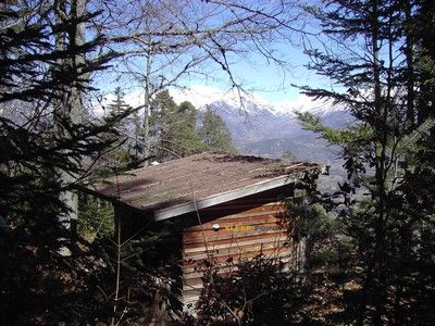
The Abri du bois du Permay refuge stands at 1240 meters above sea level, overlooking the surroundings of les guions, les flandrins, cordéac, châtel-en-trièves, grenoble, isère, auvergne-rhône-alpes, francia metropolitana, 38710, francia. It is a key spot for mountaineers looking to spend the night or take a break. Its coordinates (44.816, 5.84) place it in a strategic position for exploring the peaks and trails of the region.

See more
See more
Usuario

Lucas Martinez

Premium user

Live weather: Abri du bois du Permay

Attention hikers heading to Abri du bois du Permay: current conditions are 11.7°C (feels like 10.1°C due to 1.5 km/h wind). Beware of gusts up to 8.6 km/h. Snow level at 3910 m, UV index at 0.5, and an expected high of 16.7°C.
Temperature

11.7°C

Feels like: 10.1°C
Wind

1.5 km/h

Gusts: 8.6 km/h
Freezing level 0°

3910 m

Snow line
Sky & UV

UV 0.5

Clouds: 100%

Next 48 hours evolution

7-day forecast

04/06
16.7° 8.7°
30.2 mm 18.2 km/h UV máx: 4.6
05:52 21:17
05/06
12° 6.8°
0 mm 14.1 km/h UV máx: 6.65
05:51 21:18
06/06
19.5° 7.6°
0 mm 15.6 km/h UV máx: 7.8
05:51 21:19
07/06
19.9° 8.4°
0 mm 9.2 km/h UV máx: 7.75
05:51 21:19
08/06
23.6° 10.1°
0 mm 10.6 km/h UV máx: 7.1
05:50 21:20
09/06
19.5° 11.7°
0 mm 11.5 km/h UV máx: 2.7
05:50 21:21
10/06
16° 9.3°
0 mm 12.6 km/h UV máx: 7.55
05:50 21:21

Located on the side of the Trièves, the Abri du bois du Permay is located at 1240 meters of altitude, in a transition area within the Prealpes del Delfinado . This sector of the Isère marks the limit between the forest areas and the mineral terrain that ascends to the large massives. Your position at Châtel-en-Trièves It serves as a reference before facing the most demanding slopes of the massif.

Access to this point connects with local itineraries such as Sentier découverte - Le Ruisseau des Pavés or Bouchle de Morges . These routes allow to explore the immediate environment of the forest, facilitating the transit to the higher levels where the relief becomes more abrupt. It is a functional point of passage for those who seek to link the valleys with the crest that define the horizon of this area of Auvergne- Rhône- Alpes .

From the location of the shelter, geography is quickly raised to peaks of relevance such as the Grande Tête de l'Obiou , which with its 2789 meters dominates the environment. Other elevations such as l'Aiguille or Le Chatel strengthen the Alpine character of the sector. The shelter acts as a basic logistical support before the path leaves the protection of the tree to enter areas of pedestal and exposed rock.

Given its nature, the use of this free shelter requires strict planning in terms of mountain autonomy . The water supply is not immediate, with the nearest catchment points located more than a kilometre away. It is essential to provide for the load of liquids and the necessary equipment, especially in the light of the weather variability of the Prealpes, where the shelter offers an essential but limited storage in services.

Hiking routes from the refuge

Local

Sentier découverte - Le Ruisseau des Pavés

↔ Variable distance
Local

Boucle de Morges

↔ Variable distance

Nearby peaks

Grande Tête de l'Obiou

2789 m
Lat: 44.7753 Lon: 5.8395

l'Aiguille

2037 m
Lat: 44.8026 Lon: 5.8238

Jenabran

1597 m
Lat: 44.7955 Lon: 5.8841

Tête de la Garde

1769 m
Lat: 44.7783 Lon: 5.8808

Le Chatel

1937 m
Lat: 44.8132 Lon: 5.8118

Bonnet de l'Évêque

2663 m
Lat: 44.7722 Lon: 5.8301

Le Chauvet

1705 m
Lat: 44.8511 Lon: 5.8904

Tête de la Cavale

2697 m
Lat: 44.7674 Lon: 5.8283

Nearby water fountains

Fuente

1.27 Km
Lat: 44.7674 Lon: 5.8283

Fuente

1.28 Km
Lat: 44.7674 Lon: 5.8283

Fuente

3.71 Km
Lat: 44.7674 Lon: 5.8283

Fuente

4.01 Km
Lat: 44.7674 Lon: 5.8283

Fuente

4.51 Km
Lat: 44.7674 Lon: 5.8283

Source des Baumes

4.63 Km
Lat: 44.7674 Lon: 5.8283

Fuente

4.8 Km
Lat: 44.7674 Lon: 5.8283

Fuente

5.65 Km
Lat: 44.7674 Lon: 5.8283
FAQ

Frequently asked questions

Pregunta frecuente
At what exact altitude is the Abri du bois du Permay refuge located?
The Abri du bois du Permay refuge is located at an altitude of 1240 meters above sea level, in the natural surroundings of les guions, les flandrins, cordéac, châtel-en-trièves, grenoble, isère, auvergne-rhône-alpes, francia metropolitana, 38710, francia.
Pregunta frecuente
What are the GPS coordinates of the Abri du bois du Permay refuge?
To locate the Abri du bois du Permay refuge on your GPS or map, use the following coordinates: Latitude 44.816 and Longitude 5.84.
Pregunta frecuente
Is it necessary to carry a GPS to reach the Abri du bois du Permay refuge?
It is always highly recommended to carry a GPS device, a route track, or a topographic map in the mountains. You can use the coordinates 44.816, 5.84 to locate this refuge precisely.
More areas

Other areas

Collaborative

Together we improve

image

Send your photos

You can upload photos of shelters and update their status so other users know if they can go there.

Get started
Get started
image

Rate the shelter

Leave your comments to rate the shelter’s condition. In the mountains, we look after each other.

Get started
Get started
image

Add new ones

Did we miss any? Publish the shelters you know so everyone can use them.

Get started
Get started
Download for free from the Apple App Store and Play Store.

Download the app and start looking for the shelter of your next adventure

Aplicación móvil para encontrar refugios de montaña donde dormir
Aplicación móvil para encontrar refugios de montaña donde dormir.
Mapa interactivo de refugios de montaña en los Pirineos dentro de la app
Mapa de refugios de montaña para senderismo y trekking en la app.
Pantalla con información de refugio de montaña con altitud capacidad y servicios
Pantalla con información de refugio de montaña con altitud capacidad y servicios.
Detalles de refugio de montaña con servicios y meteorología en aplicación móvil
Detalles de refugio de montaña con servicios y meteorología en aplicación móvil.
Aplicación para explorar refugios de montaña mediante mapa interactivo
Aplicación para explorar refugios de montaña mediante mapa interactivo.
Ficha completa de refugio de montaña con opiniones y servicios
Ficha completa de refugio de montaña con opiniones y servicios.
Información detallada de refugio en app para montañeros
Información detallada de refugio en app para montañeros.
Listado de refugios de montaña para senderismo y trekking
Listado de refugios de montaña para senderismo y trekking.
Explorar refugios de montaña desde una aplicación móvil
Explorar refugios de montaña desde una aplicación móvil.