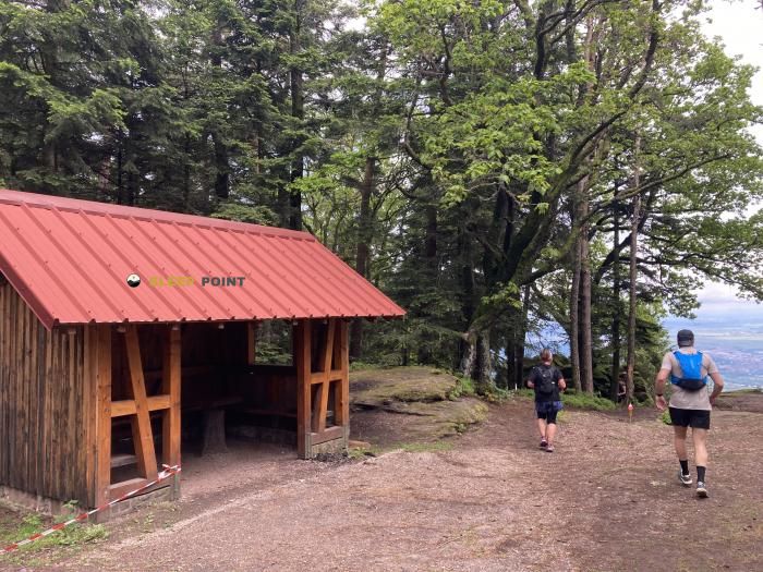
Mountain refuge Abri de La Holderlach
We have it listed in the app!
We have it listed in the app!


Located in the heart of abri de l'homburger schloss, chemin de la montagne, barr, sélestat-erstein, bajo-rin, gran este, francia metropolitana, 67140, francia, the Abri de La Holderlach refuge offers shelter at 644 meters above sea level. Ideal for trekking and nature lovers, this mountain shelter (Lat: 48.409, Lon: 7.377) is the perfect starting point or resting place for local routes.
14°C
Feels like: 11.7°C16.4 km/h
Gusts: 49.3 km/h3310 m
Snow lineUV 0.35
Clouds: 100% 6.4 mm
 26.9 km/h
 UV máx: 4.05
 05:31
05:31
 21:26
0 mm
15.5 km/h
UV máx: 6.7
05:31
21:26
0.4 mm
13.5 km/h
UV máx: 6.9
05:30
21:27
0 mm
14.2 km/h
UV máx: 6.1
05:30
21:28
0.3 mm
8.9 km/h
UV máx: 5.9
05:29
21:29
1.5 mm
16.6 km/h
UV máx: 6.45
05:29
21:29
0 mm
10.6 km/h
UV máx: 6.7
05:29
21:30
21:26
0 mm
15.5 km/h
UV máx: 6.7
05:31
21:26
0.4 mm
13.5 km/h
UV máx: 6.9
05:30
21:27
0 mm
14.2 km/h
UV máx: 6.1
05:30
21:28
0.3 mm
8.9 km/h
UV máx: 5.9
05:29
21:29
1.5 mm
16.6 km/h
UV máx: 6.45
05:29
21:29
0 mm
10.6 km/h
UV máx: 6.7
05:29
21:30
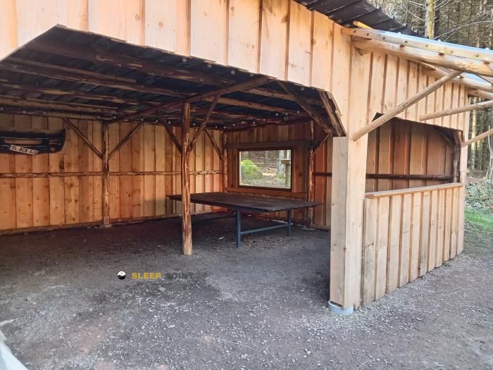
In Abri de La Holderlach The day should be provided with sufficient autonomy, particularly with regard to water. The sources recorded in the environment are more than 3 km away, with references such as Badstube Source or Source Sainte- Odile, so it is not prudent to have an immediate supply next to the coat. This distance, together with its character as a free shelter, makes it advisable to arrive with closed water, food and material for time changes.
The coat appears on the mountain over Barr in the Alsatian sector of the Vosges at 644 metres of altitude. It is not in a high-mountain pirenaic environment, but it is in a half-mountain of marked relief, where the land can quickly change between forest roads, more open slopes and less obvious orientation sections according to the local network of trails. Its location fits into a transition strip between the medium-sized forest and the elevations that dominate the Alsace plain.
This context is better understood by the closeness of the Mont Sainte- Odile , geographical and historical reference of the area, and by other nearby cims such as Kienberg or Ungersberg. More than working as a basis for great ascension, Abri de La Holderlach can serve as a guard or support on mountain tours along the corral and the slopes that link these reliefs. The practical utility is to offer an intermediate point within a wavy, wooded, and with continuous levels, where progression depends more on the orientation and management of the effort than on the absolute altitude.
The chemin reference of the montagne and the proximity of the whole of Sainte-Odile help to place it in a area of mountain passage known within the Lower Rhine, although this does not eliminate the need for caution. Without specific data on internal equipment or current state, it is reasonable to understand it as a basic coat: useful to protect itself, but not to depend on services that are not confirmed. It is also appropriate to review meteorology and mapping before leaving, as in this type of mountain the forest can close visibility and longer than planned a simple day on the map.


Download the app and start looking for the shelter of your next adventure


Find a place to sleep before night falls.