Mountain refuge Abri de la Chourelle

We have it listed in the app!


            Mountain refuge Abri de la Chourelle in abri de la chourelle, sentier gobert, villard-de-lans, grenoble, isère, auvergne-rhône-alpes, francia metropolitana, 38250, francia
Five orange stars in a horizontal row representing a five-star rating.

Abri de la Chourelle

Lat: 45.057xxx – Lon: 5.591xxx
📍 abri de la chourelle, sentier gobert, villard-de-lans, grenoble, isère, auvergne-rhône-alpes, francia metropolitana, 38250, francia
Abri de la Chourelle

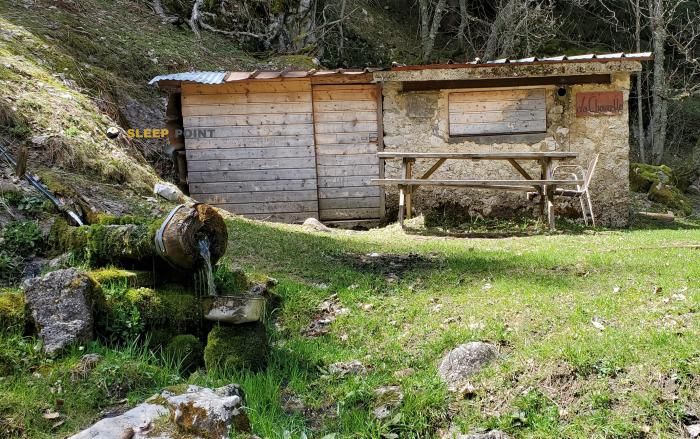
Protected by the wild surroundings of abri de la chourelle, sentier gobert, villard-de-lans, grenoble, isère, auvergne-rhône-alpes, francia metropolitana, 38250, francia, the Abri de la Chourelle refuge is your best ally at 1509 meters of elevation. Once you reach its coordinates (45.057, 5.591), you can enjoy a well-deserved mountain rest.

See more
See more
Usuario

Lucas Martinez

Premium user

Live weather: Abri de la Chourelle

The current weather in Abri de la Chourelle indicates a temperature of 8.8°C, although the 0.4 km/h wind makes it feel like 7°C. Watch out for gusts of 18.7 km/h. The snow altitude (freezing level 0°) is around 4130 m and today we will reach a high of 13.9°C.
Temperature

8.8°C

Feels like: 7°C
Wind

0.4 km/h

Gusts: 18.7 km/h
Freezing level 0°

4130 m

Snow line
Sky & UV

UV 0

Clouds: 54%

Next 48 hours evolution

7-day forecast

04/06
13.9° 6.9°
28.6 mm 19.6 km/h UV máx: 4.65
05:52 21:19
05/06
9.9°
0.1 mm 15.1 km/h UV máx: 5.45
05:51 21:20
06/06
16.7° 6.3°
0 mm 9.8 km/h UV máx: 7.6
05:51 21:21
07/06
17° 7.7°
0 mm 6.2 km/h UV máx: 7.25
05:51 21:21
08/06
20.1° 9.6°
0 mm 12 km/h UV máx: 6.4
05:50 21:22
09/06
13.3° 8.7°
2.7 mm 13.5 km/h UV máx: 4
05:50 21:23
10/06
16.1°
0 mm 8.1 km/h UV máx: 7.35
05:50 21:23

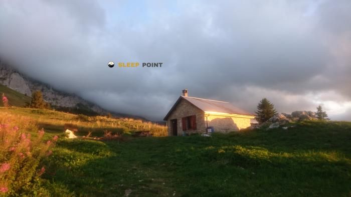
On the Villard-de-Lans , within the department of Isère and in the surroundings of Grenoble, the Abri de la Chourelle It appears as a medium and high coat that moves in a mountain strip already exposed to the change of time. Its 1509 meters place it above the low forest and close to the most marked reliefs of the sector, with close references such as the Sommet du Ranc des Agnelons at 1974 metres, or Rocher de l'Eperrimont . This context helps to understand its role: not so much as a destination in itself, but as basic support in an area where the land can go from a forest path to a more open and stony slope as it gains height.

Access must be considered with mountain logic and with margin. There are no data here on specific itineraries, times or equipment, so it is appropriate to deal with it with real autonomy and without having more services than those confirmed. In logistical terms, water deserves prior attention: the nearest source is about 1.1 km away, and there are other points at a greater distance, but that does not amount to guaranteed availability at any time. For those who use this shelter as a safe haven or point of passage, the key is to get out with sufficient supply, to review the weather and not to make clear or comfortable traces. In an area of near relief and changing orientation, this practical approach weighs more than any other consideration.

Nearby peaks

Sommet du Ranc des Agnelons

1974 m
Lat: 45.0335 Lon: 5.5921

Le Pieu

1270 m
Lat: 45.0525 Lon: 5.6408

Rochers de Brise Tourte

1017 m
Lat: 45.0555 Lon: 5.6436

Rocher Saint-Loup

700 m
Lat: 45.0657 Lon: 5.662

Sommet de Meillarot

1361 m
Lat: 45.0914 Lon: 5.5374

Rocher de l'Éperrimont

1441 m
Lat: 45.0288 Lon: 5.6179

Rochers de l'Ours

2038 m
Lat: 45.0688 Lon: 5.6055

Roc Cornafion

2049 m
Lat: 45.0627 Lon: 5.6008

Nearby water fountains

Fuente

1.1 Km
Lat: 45.0627 Lon: 5.6008

Fuente

1.82 Km
Lat: 45.0627 Lon: 5.6008

Fuente

2.05 Km
Lat: 45.0627 Lon: 5.6008

Fuente

2.79 Km
Lat: 45.0627 Lon: 5.6008

Fuente

2.91 Km
Lat: 45.0627 Lon: 5.6008

Fuente

3.03 Km
Lat: 45.0627 Lon: 5.6008

Source du Col de l'Arc

3.08 Km
Lat: 45.0627 Lon: 5.6008

Fuente

3.29 Km
Lat: 45.0627 Lon: 5.6008
FAQ

Frequently asked questions

Pregunta frecuente
Are there other mountain refuges near Abri de la Chourelle?
Yes, nearby you can find other options to spend the night or take shelter. El refugio más próximo es el Cabane des Clots (ou de Roybon), que se encuentra a aproximadamente 0.5 km de distancia.
Pregunta frecuente
At what exact altitude is the Abri de la Chourelle refuge located?
The Abri de la Chourelle refuge is located at an altitude of 1509 meters above sea level, in the natural surroundings of abri de la chourelle, sentier gobert, villard-de-lans, grenoble, isère, auvergne-rhône-alpes, francia metropolitana, 38250, francia.
Pregunta frecuente
What are the GPS coordinates of the Abri de la Chourelle refuge?
To locate the Abri de la Chourelle refuge on your GPS or map, use the following coordinates: Latitude 45.057 and Longitude 5.591.
More areas

Other areas

Collaborative

Together we improve

image

Send your photos

You can upload photos of shelters and update their status so other users know if they can go there.

Get started
Get started
image

Rate the shelter

Leave your comments to rate the shelter’s condition. In the mountains, we look after each other.

Get started
Get started
image

Add new ones

Did we miss any? Publish the shelters you know so everyone can use them.

Get started
Get started
Download for free from the Apple App Store and Play Store.

Download the app and start looking for the shelter of your next adventure

Aplicación móvil para encontrar refugios de montaña donde dormir
Aplicación móvil para encontrar refugios de montaña donde dormir.
Mapa interactivo de refugios de montaña en los Pirineos dentro de la app
Mapa de refugios de montaña para senderismo y trekking en la app.
Pantalla con información de refugio de montaña con altitud capacidad y servicios
Pantalla con información de refugio de montaña con altitud capacidad y servicios.
Detalles de refugio de montaña con servicios y meteorología en aplicación móvil
Detalles de refugio de montaña con servicios y meteorología en aplicación móvil.
Aplicación para explorar refugios de montaña mediante mapa interactivo
Aplicación para explorar refugios de montaña mediante mapa interactivo.
Ficha completa de refugio de montaña con opiniones y servicios
Ficha completa de refugio de montaña con opiniones y servicios.
Información detallada de refugio en app para montañeros
Información detallada de refugio en app para montañeros.
Listado de refugios de montaña para senderismo y trekking
Listado de refugios de montaña para senderismo y trekking.
Explorar refugios de montaña desde una aplicación móvil
Explorar refugios de montaña desde una aplicación móvil.