Mountain refuge Refuge Entre le Lac
We have it listed in the app!
We have it listed in the app!
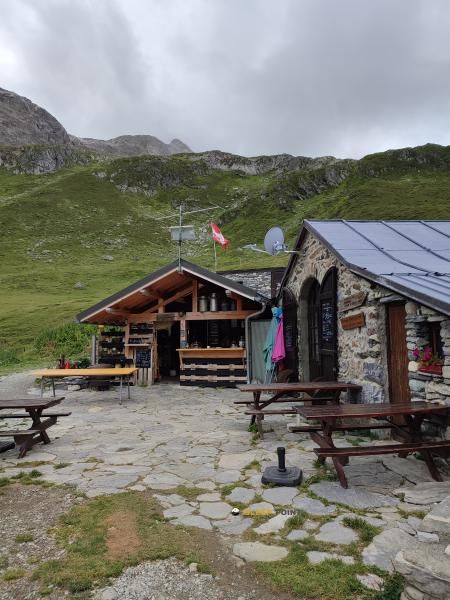

Discover the vastness of refuge entre-le-lac, pont du varchet, peisey-nancroix, albertville, saboya, auvergne-rhône-alpes, francia metropolitana, 73210, francia by spending the night at the Refuge Entre le Lac refuge. It sits at 2146 meters, offering a unique balcony over the natural landscape. Find it on the map at latitude 45.481 and longitude 6.839.
7.9°C
Feels like: 3.5°C9.4 km/h
Gusts: 20.5 km/h3840 m
Snow lineUV 0
Clouds: 100% 28.4 mm
 15.3 km/h
 UV máx: 5.75
 05:45
05:45
 21:16
0.8 mm
8.9 km/h
UV máx: 6.8
05:45
21:17
0 mm
17.9 km/h
UV máx: 8
05:45
21:17
0 mm
12.7 km/h
UV máx: 8
05:44
21:18
0.45 mm
12.2 km/h
UV máx: 7.85
05:44
21:19
1.5 mm
15.3 km/h
UV máx: 3.5
05:44
21:19
0 mm
11.2 km/h
UV máx: 7.7
05:43
21:20
21:16
0.8 mm
8.9 km/h
UV máx: 6.8
05:45
21:17
0 mm
17.9 km/h
UV máx: 8
05:45
21:17
0 mm
12.7 km/h
UV máx: 8
05:44
21:18
0.45 mm
12.2 km/h
UV máx: 7.85
05:44
21:19
1.5 mm
15.3 km/h
UV máx: 3.5
05:44
21:19
0 mm
11.2 km/h
UV máx: 7.7
05:43
21:20
Among the high-rise routes that cross the Peisey-Nancroix , Refuge Entre le Lac appears on a mountain strip where the day is very conditioned by weather. At 2146 meters, within the scope of the Vanoise , the shelter fits into a terrain of transition between valleys and passing routes, with a clearly alpine environment and time changes that can alter the pace of advance even without great distances.
Its practical interest is mainly in the network of routes around it. The closeness of the GR 55 and Via Alpina It makes it a useful reference to divide long journeys, reorganize a stage or raise a less exposed day to the central hours of the day and to a possible worsening of time. It also links with local trails like the Sentier des lass , which reinforces its role as a step-by-step support rather than as a simple isolated destination.
In this type of environment it is appropriate to read the access well before leaving: at this altitude, a low fog, wind or precipitation can make an apparently simple approach more slow and demanding. Planning is important if it is to link necklaces, continue to another stage or adjust times on a journey through the Vanoise, where the terrain and visibility weigh as much as the gap.
For logistics, there is a source very close to the shelter, a relevant data if you are sharing load between several days. However, in the mountains it is appropriate not to rely entirely on a single point of water without verifying recent conditions. Since there is no information here about other services or equipment, it is reasonable to raise the output with sufficient autonomy and scope for changes of time on the road.


📏 3 Km
⛰️ 2587 m

📏 3.2 Km
⛰️ 2020 m

📏 4.1 Km
⛰️ 2170 m

📏 5 Km
⛰️ 1556 m

📏 5.4 Km
⛰️ 2370 m

📏 5.7 Km
⛰️ 2040 m

📏 5.8 Km
⛰️ 1590 m

📏 5.8 Km
⛰️ 2010 m
Download the app and start looking for the shelter of your next adventure


Find a place to sleep before night falls.


