Mountain refuge Refuge de Tabernes

We have it listed in the app!


            Mountain refuge Refuge de Tabernes in refugio de tabernés, bado bachimala, gistaín, sobrarbe, huesca, aragón, 22367, españa
Five orange stars in a horizontal row representing a five-star rating.

Refuge de Tabernes

Lat: 42.674xxx – Lon: 0.361xxx
📍 refugio de tabernés, bado bachimala, gistaín, sobrarbe, huesca, aragón, 22367, españa
Refuge de Tabernes

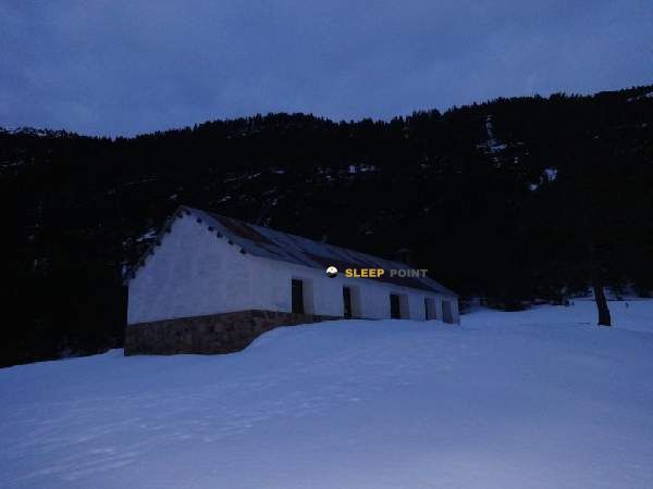
Prepare your backpack and head to refugio de tabernés, bado bachimala, gistaín, sobrarbe, huesca, aragón, 22367, españa. There you will find the Refuge de Tabernes refuge at 1740 meters of elevation. An essential stop along the way (Lat: 42.674, Lon: 0.361) for any mountain enthusiast.

See more
See more
Usuario

Lucas Martinez

Premium user

Live weather: Refuge de Tabernes

Alpine weather summary for Refuge de Tabernes: temperature at 11.4°C, feels like 10.1°C. Wind at 2.3 km/h with peaks of 9 km/h. UV index at 0 and freezing altitude at 4480 m. Maximum temperatures of 12.3°C in the coming hours.
Temperature

11.4°C

Feels like: 10.1°C
Wind

2.3 km/h

Gusts: 9 km/h
Freezing level 0°

4480 m

Snow line
Sky & UV

UV 0

Clouds: 39%

Next 48 hours evolution

7-day forecast

04/06
12.3° 6.1°
13.3 mm 12.6 km/h UV máx: 6.15
06:21 21:31
05/06
13.4° 3.7°
0 mm 15.1 km/h UV máx: 8.1
06:21 21:32
06/06
18.1°
0 mm 6.3 km/h UV máx: 7.7
06:21 21:33
07/06
20.1° 8.2°
0 mm 6.2 km/h UV máx: 8.15
06:21 21:33
08/06
19.8° 8.3°
0.3 mm 16 km/h UV máx: 8.1
06:20 21:34
09/06
17.1° 5.9°
0 mm 11.8 km/h UV máx: 5.45
06:20 21:35
10/06
19.1° 8.1°
0 mm 12.9 km/h UV máx: 7.9
06:20 21:35

Water and autonomy

We should get out with the water well planned. In the environment of Refuge de Tabernas At 1,740 meters, there are sources located from about 1.6 km, a distance sufficient to not solve that point if it is late, with fog or with changing weather. The location, in the border of Gistaín and in the area of Bado Bachimala, places this mountain shelter in a sector where logistics weighs almost as much as the tour itself.

Its position fits into a very pirenaic terrain transition strip: from valley backgrounds and more friendly sectors it is passed to more open slopes, peders and strands that, according to the chosen itinerary, can approach hills and crests. This variety is also noted in the guidance. It does not perform the same function for those who travel signposted paths of the Sobrarbe as for those who link the days of the HRP , since here the relief and exposure to time can change the pace of the day quickly.

In the near future, useful references for planning a route, such as the PR-HU 115 towards the Sen irones, various sections of the HRP and GR 19. More than just an isolated coat, it acts as a point of passage or division of day in the Gistaín Valley, within the mountain area that connects with the Posets massif and the environment of Bachimala. If there is a journey through this area of Aragon, it is appropriate to rely on current mapping, to review weather forecasting and not to have unconfirmed resources on the ground.

Hiking routes from the refuge

PR-HU 115

Puén Pecadó-Ibones del Sen

↔ Variable distance
GR 19

Senderos del Sobrarbe

↔ 80 km
HRP

Étape 18

↔ Variable distance
HRP

Étape 19

↔ Variable distance
HRP

HRP Étape 20

↔ Variable distance
Local

Ascensión al Posets

↔ Variable distance
HRP 18.1

Variante 18.1

↔ Variable distance
HRP 19.1

Variante 19.1

↔ Variable distance

Nearby water fountains

Fuente

1.62 Km
Lat: 0 Lon: 0

Fuente

1.96 Km
Lat: 0 Lon: 0

Fuente

9.37 Km
Lat: 0 Lon: 0

Cumo del Cabo Logá

9.39 Km
Lat: 0 Lon: 0
FAQ

Frequently asked questions

Pregunta frecuente
Are there other mountain refuges near Refuge de Tabernes?
Yes, nearby you can find other options to spend the night or take shelter. El refugio más próximo es el Cabane de Culrueba, que se encuentra a aproximadamente 0.9 km de distancia.
Pregunta frecuente
At what exact altitude is the Refuge de Tabernes refuge located?
The Refuge de Tabernes refuge is located at an altitude of 1740 meters above sea level, in the natural surroundings of refugio de tabernés, bado bachimala, gistaín, sobrarbe, huesca, aragón, 22367, españa.
Pregunta frecuente
What are the GPS coordinates of the Refuge de Tabernes refuge?
To locate the Refuge de Tabernes refuge on your GPS or map, use the following coordinates: Latitude 42.674 and Longitude 0.361.
More areas

Other areas

Collaborative

Together we improve

image

Send your photos

You can upload photos of shelters and update their status so other users know if they can go there.

Get started
Get started
image

Rate the shelter

Leave your comments to rate the shelter’s condition. In the mountains, we look after each other.

Get started
Get started
image

Add new ones

Did we miss any? Publish the shelters you know so everyone can use them.

Get started
Get started
Download for free from the Apple App Store and Play Store.

Download the app and start looking for the shelter of your next adventure

Aplicación móvil para encontrar refugios de montaña donde dormir
Aplicación móvil para encontrar refugios de montaña donde dormir.
Mapa interactivo de refugios de montaña en los Pirineos dentro de la app
Mapa de refugios de montaña para senderismo y trekking en la app.
Pantalla con información de refugio de montaña con altitud capacidad y servicios
Pantalla con información de refugio de montaña con altitud capacidad y servicios.
Detalles de refugio de montaña con servicios y meteorología en aplicación móvil
Detalles de refugio de montaña con servicios y meteorología en aplicación móvil.
Aplicación para explorar refugios de montaña mediante mapa interactivo
Aplicación para explorar refugios de montaña mediante mapa interactivo.
Ficha completa de refugio de montaña con opiniones y servicios
Ficha completa de refugio de montaña con opiniones y servicios.
Información detallada de refugio en app para montañeros
Información detallada de refugio en app para montañeros.
Listado de refugios de montaña para senderismo y trekking
Listado de refugios de montaña para senderismo y trekking.
Explorar refugios de montaña desde una aplicación móvil
Explorar refugios de montaña desde una aplicación móvil.