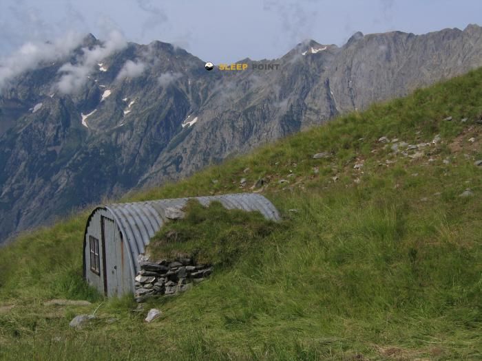
Mountain refuge Refuge communal des Sources
We have it listed in the app!
We have it listed in the app!


If you are planning a route through refuge des sources, chemin de la pyramide du lauzon, lafond, villard-notre-dame, grenoble, isère, auvergne-rhône-alpes, francia metropolitana, 38520, francia, the Refuge communal des Sources refuge is a must-stop. Located at 2268 m above sea level, it offers hikers and climbers a safe place to regain strength. Save its coordinates (44.994, 6.029) in your GPS to stay on course during your journey.
8.6°C
Feels like: 4.7°C10.4 km/h
Gusts: 31.7 km/h3680 m
Snow lineUV 1.4
Clouds: 100% 37.4 mm
 20.3 km/h
 UV máx: 4.3
 05:51
05:51
 21:17
0.4 mm
12.9 km/h
UV máx: 7.5
05:50
21:18
0 mm
12.8 km/h
UV máx: 8.05
05:50
21:19
0 mm
6.8 km/h
UV máx: 6.9
05:49
21:19
0 mm
15.1 km/h
UV máx: 7.3
05:49
21:20
0.15 mm
12.3 km/h
UV máx: 6.85
05:49
21:21
0 mm
12 km/h
UV máx: 7.75
05:49
21:21
21:17
0.4 mm
12.9 km/h
UV máx: 7.5
05:50
21:18
0 mm
12.8 km/h
UV máx: 8.05
05:50
21:19
0 mm
6.8 km/h
UV máx: 6.9
05:49
21:19
0 mm
15.1 km/h
UV máx: 7.3
05:49
21:20
0.15 mm
12.3 km/h
UV máx: 6.85
05:49
21:21
0 mm
12 km/h
UV máx: 7.75
05:49
21:21
On the Villard-Notre-Dame within the Oisans sector that looks at the Ecrins massif, this shelter fits better on a day of passage or withdrawal than on an improvised stop. Its position relates it naturally to the large trails of the area, especially the GR 54 , known as Tour de l'Oisans et Écrins, and with the GR 50 , which surrounds the National Park of the Ecrins by very varied heights and valleys.
That context helps to understand its role. In a land where meteorology can change quickly and where a long journey forces to link hills, slopes and mountain paths for hours, a communal shelter at 2268 meters allows to divide stages, shorten a day or have a point of withdrawal if the time is closed. It can also serve as a support within the Oisans' more flexible and variable distance network, useful for adapting the itinerary on the way.
It does not appear associated here with specific summits, so it should be read above all as a shelter for itinerary and not as a clear basis for ascension. Its interest is in the general orientation of the sector and in the possibility to fit into more long circular or cross-country routes. In an alpine area like this, exposure to the wind, fog or an afternoon storm can completely change the pace of the march. That is why planning must be prudent.
The logistics should also be taken into account. The registered sources are several kilometres away, with the closest to about 2.8 km, so it is not reasonable to take the water for granted by the shelter. For a stage in this sector of the Oisans, it is wise to go out with sufficient autonomy and to review the state of the itinerary and the weather forecast.
Refuge communal des Sources is located as a mountain shelter in the surroundings of the Ecrins thought more to manage the day well than to add unnecessary objectives: a useful point when the relief forces to measure distances, sky and maneuver space.


📏 1.4 Km
⛰️ 2294 m

📏 2.3 Km
⛰️ 1730 m

📏 2.6 Km
⛰️ 2000 m
📏 2.7 Km
⛰️ 2081 m

📏 3.1 Km
⛰️ 2405 m

📏 3.2 Km
⛰️ 2411 m

📏 3.2 Km
⛰️ 1560 m

📏 3.5 Km
⛰️ 1790 m
Download the app and start looking for the shelter of your next adventure


Find a place to sleep before night falls.


