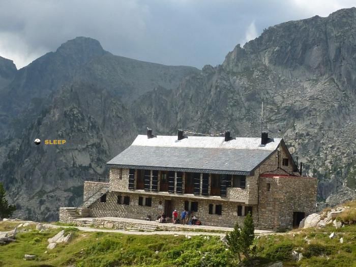
Mountain refuge Refuge Centraleta
We have it listed in the app!
We have it listed in the app!


If you are looking for total disconnection, venture into refugi de la centraleta, camí d'aigüestortes a l'estany de sant maurici, la vall de boí, alta ribagorza, lérida, cataluña, 25528, españa until you reach the Refuge Centraleta refuge, positioned at 1920 meters. Use your device to navigate to the exact point (42.571, 0.936) to find this alpine shelter.
9.6°C
Feels like: 7.4°C8.8 km/h
Gusts: 24.1 km/h4340 m
Snow lineUV 1
Clouds: 100% 3.9 mm
 24 km/h
 UV máx: 7.1
 06:20
06:20
 21:29
0 mm
18.1 km/h
UV máx: 8.15
06:19
21:29
0 mm
9.2 km/h
UV máx: 7.45
06:19
21:30
0 mm
10.5 km/h
UV máx: 7.95
06:19
21:31
0.3 mm
18.3 km/h
UV máx: 8.35
06:18
21:31
8.7 mm
14.2 km/h
UV máx: 7.3
06:18
21:32
0 mm
15.5 km/h
UV máx: 7.95
06:18
21:33
21:29
0 mm
18.1 km/h
UV máx: 8.15
06:19
21:29
0 mm
9.2 km/h
UV máx: 7.45
06:19
21:30
0 mm
10.5 km/h
UV máx: 7.95
06:19
21:31
0.3 mm
18.3 km/h
UV máx: 8.35
06:18
21:31
8.7 mm
14.2 km/h
UV máx: 7.3
06:18
21:32
0 mm
15.5 km/h
UV máx: 7.95
06:18
21:33
The approach runs through valley terrain. Central Refuge appears on the axis of the camí d'Aigüespertes a l'estany de Sant Maurici, within the Vall de Boí and in the surroundings of the National Park of Aigüestortes i Estany de Sant Maurici . At 1,920 meters, its position fits better as a support on a long day than as an isolated destination: it is in an area where the itineraries can change character quickly, from comfortable progression through the valley bottom to sections more exposed to the wind, fog or sudden worsening when the hills and high sectors of the park are linked. That is why it is useful both as a free-of-way shelter and to divide stages if you are walking the area with margin. Its location also relates it to well-known traverses of the Catalan Pyrenees, among them Foc Carros , HRP and the variant GR 11.20 , in addition to other long-range links that cross the massif.
This liaison role requires careful planning. There are no sources close to the shelter: the nearest water references are more than 6 km away, so it is necessary not to have immediate supply and to leave with sufficient autonomy. In an area so frequented by cross-border events, the practical decision is often whether to use it as a simple point of passage or as a basis for reorganizing the day according to meteorology, but without data from nearby summits it makes no sense to present it as a shelter for concrete ascension. The Sant Nicolau valley and the corridor between Aigüestortes and Sant Maurici concentrate much of this mountain transit, with changes of orientation that can affect the visibility, the state of the land and the pace of the march. If it is planned to continue to high sectors or to link long stages, the state of the itinerary, time and water available should be reviewed first, because the altitude and relative isolation of this point penalize the errors of calculation.


📏 0.5 Km
⛰️ 1984.8 m

📏 1 Km
⛰️ 1985 m

📏 4.6 Km
⛰️ 1628 m

📏 4.9 Km
⛰️ 2380 m
📏 4.9 Km
⛰️ 2380 m

📏 5.2 Km
⛰️ 2235m m

📏 5.5 Km
⛰️ 2300m m

📏 6 Km
⛰️ 1885 m
Download the app and start looking for the shelter of your next adventure


Find a place to sleep before night falls.


