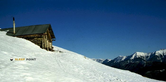
Mountain refuge Le Château
We have it listed in the app!
We have it listed in the app!


Discover the vastness of le rousset, la javie, digne-les-bains, alpes de alta provenza, provenza-alpes-costa azul, francia metropolitana, 04420, francia by spending the night at the Le Château refuge. It sits at 1302 meters, offering a unique balcony over the natural landscape. Find it on the map at latitude 44.231 and longitude 6.291.
11.2°C
Feels like: 8.3°C7.6 km/h
Gusts: 17.6 km/h4230 m
Snow lineUV 0
Clouds: 76% 9.1 mm
 20.4 km/h
 UV máx: 7.3
 05:52
05:52
 21:13
0.3 mm
12.7 km/h
UV máx: 7.35
05:52
21:14
0 mm
15.1 km/h
UV máx: 7.85
05:51
21:15
0 mm
11.3 km/h
UV máx: 7.75
05:51
21:15
0 mm
15.4 km/h
UV máx: 7.85
05:51
21:16
0 mm
22.2 km/h
UV máx: 6.95
05:50
21:17
0 mm
16.3 km/h
UV máx: 7.6
05:50
21:17
21:13
0.3 mm
12.7 km/h
UV máx: 7.35
05:52
21:14
0 mm
15.1 km/h
UV máx: 7.85
05:51
21:15
0 mm
11.3 km/h
UV máx: 7.75
05:51
21:15
0 mm
15.4 km/h
UV máx: 7.85
05:51
21:16
0 mm
22.2 km/h
UV máx: 6.95
05:50
21:17
0 mm
16.3 km/h
UV máx: 7.6
05:50
21:17
On the La Javie , Le Château It works mainly as a shelter for half a mountain. Its 1302 meters place it in a useful place to break days in the Alpes de Alta Provence, on a land that already begins to gain mountain character without still entering a high strict mountain.
From this position, the shelter fits well in routes that link local roads and walkways between valleys, with close references such as the Chemin pastoral de La Javie à Le Vernet or the Le Serre d'Eclangon . The near presence of Blayeul helps read the relief: long slopes, orientation changes and a progression that can be quickly hardened if the day continues to higher levels. More than an isolated destination, it is better understood as support to reorganize a stage, shorten a link or propose a withdrawal to lower areas.
The environment combines half-mountain references with steps that may be exposed to changing time, something important in this part of Provence-Alpes- Costa Azul. Although not in an extreme location, the planning should be made with a clear map of access and alternatives, especially if it is used as an intermediate point on long or unlinear routes.
In logistics, water deserves prior attention. The nearest source is Font Chaude , about 1.86 km, an assumed but not immediate distance if you arrive late or with unstable forecast. For this reason, in order to use this safe haven, it is necessary to have basic autonomy and not to depend on finding resources just when they arrive.


📏 2.4 Km
⛰️ 1060 m

📏 2.6 Km
⛰️ 948 m

📏 2.8 Km
⛰️ 1490 m
📏 3.2 Km
⛰️ 1640 m

📏 4.5 Km
⛰️ 1215 m

📏 5.3 Km
⛰️ 1499 m

📏 5.6 Km
⛰️ 1126 m

📏 6.3 Km
⛰️ 1700 m
Download the app and start looking for the shelter of your next adventure


Find a place to sleep before night falls.


