Mountain refuge Font Frede
We have it listed in the app!
We have it listed in the app!

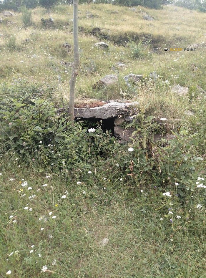
With a privileged location in terreny d'acampada fonjumina, camí a fontalba, la ruïra, queralbs, ripollés, gerona, cataluña, españa, the Font Frede refuge awaits you at 1760 meters of altitude. Note its position (42.355, 2.16) before starting your route through the mountain range or massif.
13.4°C
Feels like: 12.3°C3.8 km/h
Gusts: 4.7 km/h4420 m
Snow lineUV 2.3
Clouds: 100% 15.73 mm
 13.2 km/h
 UV máx: 6.95
 06:15
06:15
 21:23
0 mm
9.3 km/h
UV máx: 7.65
06:15
21:24
0.3 mm
10.9 km/h
UV máx: 7.6
06:15
21:24
0 mm
11.6 km/h
UV máx: 7.35
06:14
21:25
0.3 mm
11.1 km/h
UV máx: 8.2
06:14
21:26
7.2 mm
14.6 km/h
UV máx: 7.65
06:14
21:26
0.3 mm
11.5 km/h
UV máx: 7.8
06:14
21:27
21:23
0 mm
9.3 km/h
UV máx: 7.65
06:15
21:24
0.3 mm
10.9 km/h
UV máx: 7.6
06:15
21:24
0 mm
11.6 km/h
UV máx: 7.35
06:14
21:25
0.3 mm
11.1 km/h
UV máx: 8.2
06:14
21:26
7.2 mm
14.6 km/h
UV máx: 7.65
06:14
21:26
0.3 mm
11.5 km/h
UV máx: 7.8
06:14
21:27
The high slopes of Queralbs link forests, clear and open ground before winning the most rough relief leading to the pirenaic divisive. In this sector of the Ripollès, already close to the axis of summits that separates valleys and connects with cross-border itineraries, the mountain changes quickly of character: average levels still accessible from the environment of Fontalba and, above, a landscape of peaks and peaks such as the Balandrau or the peaks of Segre that mark a clearly mountainous environment.
Font Frede at 1760 meters, it fits into that transition strip between relatively comfortable access and the most exposed high mountain. Their interest does not depend so much on a high altitude as on the position: it serves as a support in an area where continuity routes are crossed, and it can be useful to break days or link itineraries that move between Queralbs, the nearby cords and the eastern pyrenian side.
That function is better understood when you see your relationship with long journeys. Through the environment the HRP and several of its variants, in addition to proposals such as Refugees of the Torb . It is not appropriate to read it as a simple, isolated coat, but as a point that can fit within several days, where the orientation of the terrain, the time changes and the continuity of the march weigh more than the linear distance.
In such an area, meteorology can make the day very difficult even if the initial access does not seem extreme. Wind, fog and sudden changes are common factors in open levels of the Eastern Pyrenees, especially when collars or exposed lomas are linked. The proximity of relatively close summits does not imply simple ascension, and the ground calls for criteria for assessing the state of the sky, visibility and real autonomy.
For water, there are several sources in the Queralbs environment and one of the closest is Font del Raig, less than 600 meters away. However, in mountain exits it is appropriate to confirm flow rate and not to rely entirely on a single point. If it is proposed as a long-time or journey support, it is reasonable to arrive with sufficient water, food and equipment for time changes.


📏 1.4 Km
⛰️ 1460 m

📏 2 Km
⛰️ 1600 m

📏 2.1 Km
⛰️ 1623 m
📏 2.9 Km
⛰️ 1771 m

📏 3.4 Km
⛰️ 1515 m

📏 3.5 Km
⛰️ 2145 m

📏 3.9 Km
⛰️ 1986 m

📏 4 Km
⛰️ 2110m m
Download the app and start looking for the shelter of your next adventure


Find a place to sleep before night falls.


