Mountain refuge Chalet de Saint-Guilhem-le-Désert
We have it listed in the app!
We have it listed in the app!


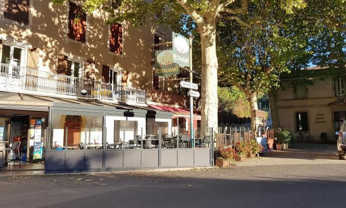
The mountains of chalet de saint-guilhem-le-désert, 5, rue cor de nostra dona, saint-guilhem-le-désert, lodève, hérault, occitania, francia metropolitana, 34150, francia hide essential places like the Chalet de Saint-Guilhem-le-Désert refuge. Situated at an elevation of 89 meters, it offers protection and rest. Its exact coordinates are 43.734, 3.549.
17°C
Feels like: 16.8°C4.6 km/h
Gusts: 8.6 km/h4210 m
Snow lineUV 0
Clouds: 99% 7.7 mm
 30.3 km/h
 UV máx: 5.15
 06:05
06:05
 21:22
0 mm
33.2 km/h
UV máx: 7.35
06:05
21:23
0 mm
17.5 km/h
UV máx: 7.6
06:04
21:24
0 mm
10.9 km/h
UV máx: 6.7
06:04
21:24
0 mm
14.3 km/h
UV máx: 7.65
06:04
21:25
0 mm
20.4 km/h
UV máx: 7.25
06:03
21:26
0 mm
12.1 km/h
UV máx: 7.35
06:03
21:26
21:22
0 mm
33.2 km/h
UV máx: 7.35
06:05
21:23
0 mm
17.5 km/h
UV máx: 7.6
06:04
21:24
0 mm
10.9 km/h
UV máx: 6.7
06:04
21:24
0 mm
14.3 km/h
UV máx: 7.65
06:04
21:25
0 mm
20.4 km/h
UV máx: 7.25
06:03
21:26
0 mm
12.1 km/h
UV máx: 7.35
06:03
21:26
The approach to this shelter is based on a very different context from that of an isolated coat of cords: Villa of Saint-Guilhem-le-Désert it is within the core of Saint-Guilhem-le-Désert, at the rue Cor de Nòstra Dona, only 89 meters of altitude. This makes it a useful support for those who organize the day from their own people, both at the beginning and at the end of a route, and also a clear reference if there is a need to shorten the course or to withdraw to an accessible point.
Their practical interest is linked to the network of itineraries that leave or pass through this sector of the Hérault. From here are linked tours like Les Fenestrettes , Les Balcons de l'Hérault , Seranne- Pontel or the journey CSG 11 between Saint-Maurice-Navacelles and Saint-Guilhem-le-Désert . Rather than operating as a high shelter, it fits as a base or escape point for hiking days with variable profiles, where it is appropriate to measure well the effort according to the chosen itinerary and the heat, very relevant in low and medium levels of this area.
The immediate environment helps to understand the type of land. Close to you are raised reliefs like Mont Saint-Baudille , Roc de la Vigne or Le Ginestet , which mark exits with a gap from the valley and force the progressive management of the rise. In an area with half-mountain routes and very frequent steps, this point can serve to divide the activity, reorder the day or return to the village if the weather, the rhythm of the group or fatigue do not advise to continue.
For logistics, there are several very close sources, about 170 meters away, something useful before leaving or on return. However, this does not replace prudent planning: if it is to be linked to long or ascending routes, it is necessary to go out with sufficient water, to review the concrete route and not to consider that all the itineraries have the same requirement or exposure. The presence of the people and of signposted roads facilitates the general orientation, but does not eliminate the need to foresee heat, accumulated level and margin of withdrawal.


📏 1.7 Km
⛰️ 347 m

📏 7.5 Km
⛰️ 521 m
📏 9.5 Km
⛰️ 620 m

📏 21.3 Km
⛰️ 744 m

📏 21.6 Km
⛰️ 286 m

📏 21.7 Km
⛰️ 650 m

📏 28.4 Km
⛰️ 370 m
📏 28.6 Km
⛰️ 280 m
Download the app and start looking for the shelter of your next adventure


Find a place to sleep before night falls.


