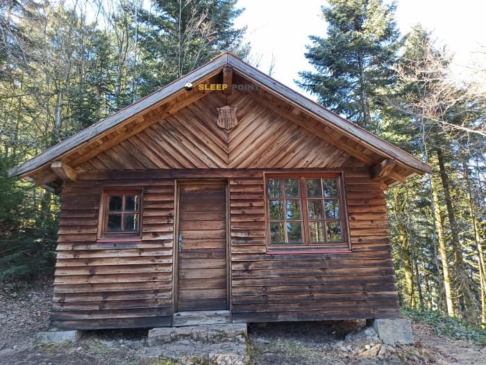
Mountain refuge Chalet de l'Alouette
We have it listed in the app!
We have it listed in the app!


Prepare your backpack and head to chalet de l'alouette, rue de la colline, ramonchamp, Épinal, vosgos, gran este, francia metropolitana, 88160, francia. There you will find the Chalet de l'Alouette refuge at 694 meters of elevation. An essential stop along the way (Lat: 47.885, Lon: 6.714) for any mountain enthusiast.
12.6°C
Feels like: 10.1°C16.3 km/h
Gusts: 47.9 km/h3670 m
Snow lineUV 0
Clouds: 96% 8.3 mm
 23.6 km/h
 UV máx: 4.55
 05:36
05:36
 21:26
0.3 mm
15.5 km/h
UV máx: 6.3
05:36
21:27
0.2 mm
17.6 km/h
UV máx: 7.05
05:35
21:28
0 mm
12.6 km/h
UV máx: 6.2
05:35
21:28
4.95 mm
10.1 km/h
UV máx: 6.1
05:34
21:29
15.9 mm
15.6 km/h
UV máx: 6.5
05:34
21:30
0 mm
7.9 km/h
UV máx: 6.8
05:34
21:30
21:26
0.3 mm
15.5 km/h
UV máx: 6.3
05:36
21:27
0.2 mm
17.6 km/h
UV máx: 7.05
05:35
21:28
0 mm
12.6 km/h
UV máx: 6.2
05:35
21:28
4.95 mm
10.1 km/h
UV máx: 6.1
05:34
21:29
15.9 mm
15.6 km/h
UV máx: 6.5
05:34
21:30
0 mm
7.9 km/h
UV máx: 6.8
05:34
21:30
Villa de l'Alouette is left on the slope of Ramonchamp, in the department of Vosgos, within the French Grand East. At 694 meters, its role fits more with the planning of a stage than with a fully alpine environment shelter: it works as a link between local routes and more continuity, with the close reference of the GR 7 and GR 501 . In this sector, the orientation changes easily between forest roads, slopes and paths linking hills and heads, so that it can serve both as a point of passage and as a short basis for exploring the network of surrounding itineraries.
This transitional nature is also seen in the field. It is not an isolated enclave in crest, but a useful position to move between medium heights and rounded reliefs of the Southern Vosgos, with close references such as Tête du Midi or Pic des Corbeaux, more relevant as reading of the landscape than as a technical objective. For walking trails, the interest is to order the day well and to anticipate the changes of direction between signposted routes and local circuits. For those who think of using it as logistical support, it is appropriate to have reasonable autonomy: the registered sources do not appear immediately to the shelter, so the water should not be taken for granted without first checking. It is also prudent to review mapping and planned mapping, especially if long routes are linked to secondary routes of the valley.


Download the app and start looking for the shelter of your next adventure


Find a place to sleep before night falls.