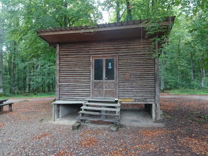
Mountain refuge Cabane vers les hautes roches de Belvoir
We have it listed in the app!
We have it listed in the app!


If you are planning a route through belvoir, montbéliard, doubs, borgoña-franco condado, francia metropolitana, 25430, francia, the Cabane vers les hautes roches de Belvoir refuge is a must-stop. Located at 658 m above sea level, it offers hikers and climbers a safe place to regain strength. Save its coordinates (47.328, 6.611) in your GPS to stay on course during your journey.
13.1°C
Feels like: 10.6°C13.3 km/h
Gusts: 30.6 km/h3570 m
Snow lineUV 0
Clouds: 54% 8.7 mm
 23.8 km/h
 UV máx: 4.5
 05:39
05:39
 21:24
0.6 mm
15.5 km/h
UV máx: 6.45
05:38
21:25
0.2 mm
16.3 km/h
UV máx: 7.15
05:38
21:26
0 mm
13.7 km/h
UV máx: 5.9
05:38
21:26
2.4 mm
11.5 km/h
UV máx: 6.55
05:37
21:27
14.1 mm
18 km/h
UV máx: 6.55
05:37
21:28
0 mm
13.4 km/h
UV máx: 7
05:37
21:28
21:24
0.6 mm
15.5 km/h
UV máx: 6.45
05:38
21:25
0.2 mm
16.3 km/h
UV máx: 7.15
05:38
21:26
0 mm
13.7 km/h
UV máx: 5.9
05:38
21:26
2.4 mm
11.5 km/h
UV máx: 6.55
05:37
21:27
14.1 mm
18 km/h
UV máx: 6.55
05:37
21:28
0 mm
13.4 km/h
UV máx: 7
05:37
21:28
In the environment of Belvoir This cabane is 658 meters away. His position, in the department of Doubs and within Burgundy - Franco Condado , links it to a relief more of lomas, rocky edges and half mountain roads than to a high-level shelter. Even so, it can perform a clear function as a walking coat in an area where it is appropriate to be well oriented with mapping and to leave with time margin.
Cabane vers les hautes roches de Belvoir It is mainly a support for walking days along the itineraries around Belvoir. Their interest increases if they are linked to routes such as Sentier des Coteaux de Belvoir , Tour du Pays de Montbéliard or Sentier du Belvédère du Peu , especially when you seek to divide a journey, shorten a stage or have a point of protection if time changes or progress becomes slower than expected.
Access and demand depend a lot on the chosen route, because there is no big Alpine axis here that simplifies the reading of the ground. This is why it is more of a tactical resource than of a destination in itself: useful when you enter the area late, with uncertain weather forecast or in long days when it is necessary to leave room for not to rush back.
In logistics, the most important data is water. The nearest registered source is about 2.78 km, and the others are far away, so it is not wise to have immediate supply next to the shelter. It is reasonable to arrive with sufficient reserve and plan the day with autonomy, both of water and of basic material, because the information available on services or equipment is limited.
This simple and unexposed nature of large infrastructure makes its usefulness dependent on the context: it can be a good reference for connecting hiking in the Belvoir and Montbéliard sector, but it requires good preparation of navigation, time and resources before leaving.


📏 3 Km
⛰️ 632 m

📏 6.9 Km
⛰️ 760 m

📏 8.4 Km
⛰️ 653 m

📏 8.7 Km
⛰️ 743 m

📏 8.7 Km
⛰️ 722 m

📏 9.4 Km
⛰️ 598 m
📏 9.7 Km
⛰️ 594 m

📏 10 Km
⛰️ 515 m
Download the app and start looking for the shelter of your next adventure


Find a place to sleep before night falls.


