Mountain refuge Cabane Auloueilh

We have it listed in the app!


            Mountain refuge Cabane Auloueilh in cabane auloueilh, sentier du pic de portarras, aulon, bagnères-de-bigorre, altos pirineos, occitania, francia metropolitana, 65240, francia
Five orange stars in a horizontal row representing a five-star rating.

Cabane Auloueilh

Lat: 42.856xxx – Lon: 0.247xxx
📍 cabane auloueilh, sentier du pic de portarras, aulon, bagnères-de-bigorre, altos pirineos, occitania, francia metropolitana, 65240, francia
Cabane Auloueilh

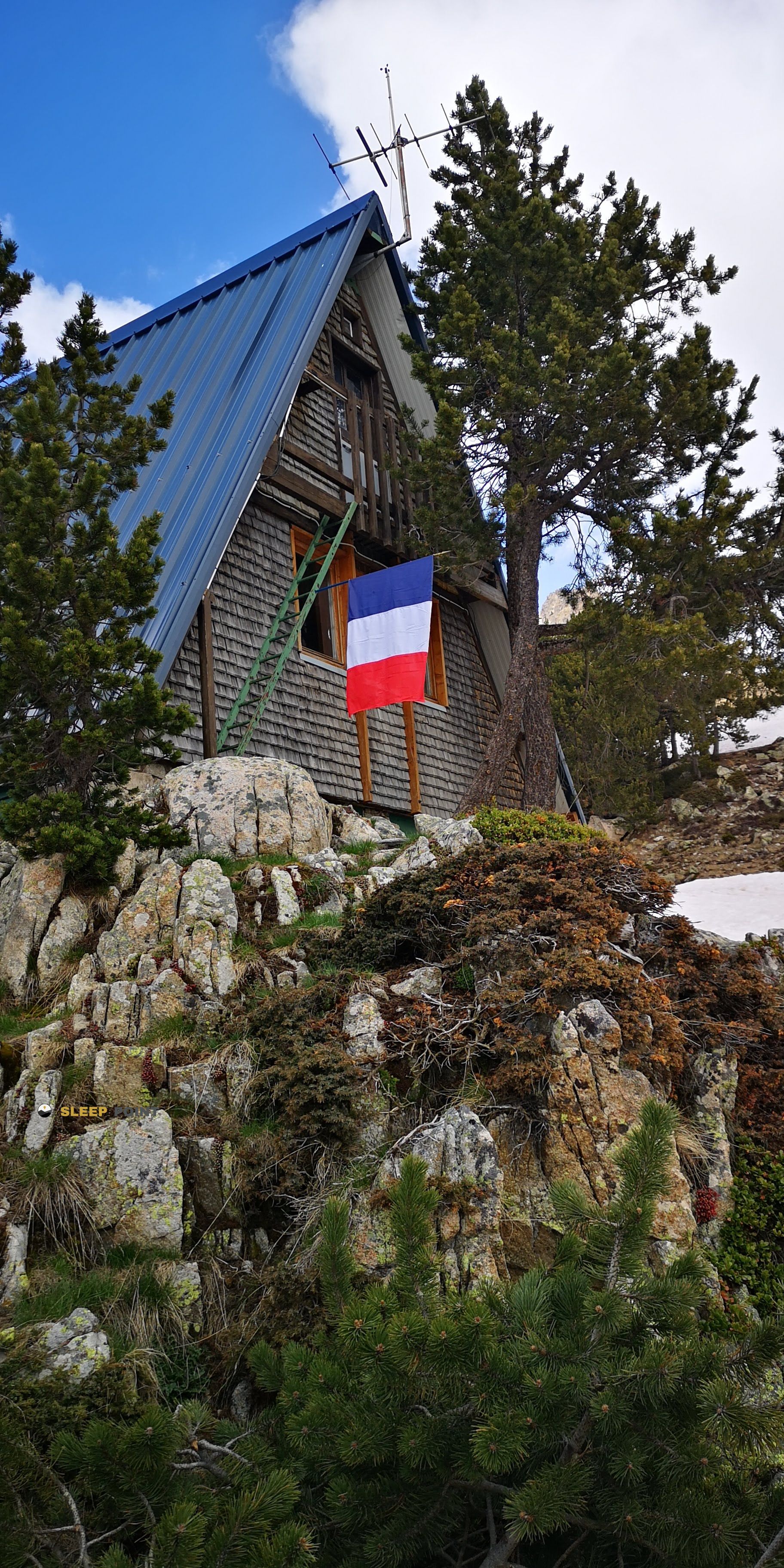
The mountains of cabane auloueilh, sentier du pic de portarras, aulon, bagnères-de-bigorre, altos pirineos, occitania, francia metropolitana, 65240, francia hide essential places like the Cabane Auloueilh refuge. Situated at an elevation of 1853 meters, it offers protection and rest. Its exact coordinates are 42.856, 0.247.

See more
See more
Usuario

Lucas Martinez

Premium user

Live weather: Cabane Auloueilh

If you plan to go up today to 1853 m at Cabane Auloueilh, you will find 9.8°C with a feels-like temperature of 7.7°C. The freezing level is at 4460 m. The forecast shows steady winds of 3.4 km/h and peaks of 7.9 km/h. A high of 13.3°C is expected.
Temperature

9.8°C

Feels like: 7.7°C
Wind

3.4 km/h

Gusts: 7.9 km/h
Freezing level 0°

4460 m

Snow line
Sky & UV

UV 0

Clouds: 20%

Next 48 hours evolution

7-day forecast

04/06
13.3° 3.3°
10.8 mm 11.4 km/h UV máx: 4.3
06:21 21:32
05/06
10.8° 1.4°
0.7 mm 9.1 km/h UV máx: 8
06:21 21:33
06/06
12.7° 6.5°
0.2 mm 8.4 km/h UV máx: 7
06:21 21:34
07/06
18.4° 7.6°
0 mm 18 km/h UV máx: 8
06:20 21:35
08/06
15.1° 6.8°
3.6 mm 10.7 km/h UV máx: 7.8
06:20 21:35
09/06
8.2° 4.8°
0.9 mm 8.8 km/h UV máx: 4.05
06:20 21:36
10/06
17.4° 4.8°
1.8 mm 8.5 km/h UV máx: 7.7
06:20 21:36

Between high pastures and the shadow of the Arbizon

The Cabane Auloueilh is hidden in the mountain of Aulon, already above the height of a thousand eight hundred, at that point where the valley begins to stay down and the landscape becomes more open, more mineral and more silent. It does not give a sense of hasty passage, but of a corner gained from a trench, after reassembling slopes where the grass and stone alternate with nature. The powerful silhouette of the Arbizon , a little more than three kilometers in a straight line, and also the relief of the Pic de Montfaucon, which strengthens that high mountain environment without even being in the big hills.

From here they fit well days that seek to link with the GR 105 or to be taken to the Tour du Lac de l'Oule, two tours that quite well summarize the character of the place: free mountain trails, with a sustained level and views that are gradually opened. The access does not feel far on the map, but on the ground it is seen on the legs, especially when the road constantly gains meters and forces to find rhythm. It is necessary to get out with enough water, because although there are sources spread around the area, the nearest one is about two and a half miles away, so it is not of those places where you fill the canteen next to the door. The cabin fits better with those who seek a sober stop, surrounded by high pastures, wide sky and that pirenees air that in Occitania blends hardness and calm.

Hiking routes from the refuge

GR 105

GR 105

↔ Variable distance
Local

Boucle de Caneilles

↔ Variable distance
Local

Tour du Lac de l'Oule

↔ Variable distance
Local

Lacs de Bastan

↔ Variable distance
Local

Col de Bastanet et Pic de Bastan

↔ Variable distance
15

Sentier de Tramespeyres

↔ Variable distance
GR 10

La traversée des Pyrénées - sec.6

↔ Variable distance
GR 10

La traversée des Pyrénées - sec.5

↔ Variable distance

Nearby peaks

Pène Male

2582 m
Lat: 42.8173 Lon: 0.24

Arbizon

2831 m
Lat: 42.876 Lon: 0.2726

tuhou d'Arredoun du bas

2502 m
Lat: 42.8745 Lon: 0.2164

Pic de Montfaucon

2712 m
Lat: 42.8799 Lon: 0.2581

Petit Arbizon

2737 m
Lat: 42.8743 Lon: 0.2804

La Tourette

2328 m
Lat: 42.8289 Lon: 0.2376

Pic de Bastan

2715 m
Lat: 42.866 Lon: 0.2007

Pic de Montarrouye

2568 m
Lat: 42.8864 Lon: 0.2245

Nearby water fountains

Fuente

2.47 Km
Lat: 42.8864 Lon: 0.2245

Fuente

3.09 Km
Lat: 42.8864 Lon: 0.2245

Fuente

4.44 Km
Lat: 42.8864 Lon: 0.2245

Fuente

4.79 Km
Lat: 42.8864 Lon: 0.2245

Fuente

4.92 Km
Lat: 42.8864 Lon: 0.2245

Fuente

5.25 Km
Lat: 42.8864 Lon: 0.2245

Fuente

5.74 Km
Lat: 42.8864 Lon: 0.2245

Fuente

6.28 Km
Lat: 42.8864 Lon: 0.2245
FAQ

Frequently asked questions

Pregunta frecuente
Are there other mountain refuges near Cabane Auloueilh?
Yes, nearby you can find other options to spend the night or take shelter. El refugio más próximo es el Cabane de Auloueilh, que se encuentra a aproximadamente 0.1 km de distancia.
Pregunta frecuente
At what exact altitude is the Cabane Auloueilh refuge located?
The Cabane Auloueilh refuge is located at an altitude of 1853 meters above sea level, in the natural surroundings of cabane auloueilh, sentier du pic de portarras, aulon, bagnères-de-bigorre, altos pirineos, occitania, francia metropolitana, 65240, francia.
Pregunta frecuente
What are the GPS coordinates of the Cabane Auloueilh refuge?
To locate the Cabane Auloueilh refuge on your GPS or map, use the following coordinates: Latitude 42.856 and Longitude 0.247.
More areas

Other areas

Collaborative

Together we improve

image

Send your photos

You can upload photos of shelters and update their status so other users know if they can go there.

Get started
Get started
image

Rate the shelter

Leave your comments to rate the shelter’s condition. In the mountains, we look after each other.

Get started
Get started
image

Add new ones

Did we miss any? Publish the shelters you know so everyone can use them.

Get started
Get started
Download for free from the Apple App Store and Play Store.

Download the app and start looking for the shelter of your next adventure

Aplicación móvil para encontrar refugios de montaña donde dormir
Aplicación móvil para encontrar refugios de montaña donde dormir.
Mapa interactivo de refugios de montaña en los Pirineos dentro de la app
Mapa de refugios de montaña para senderismo y trekking en la app.
Pantalla con información de refugio de montaña con altitud capacidad y servicios
Pantalla con información de refugio de montaña con altitud capacidad y servicios.
Detalles de refugio de montaña con servicios y meteorología en aplicación móvil
Detalles de refugio de montaña con servicios y meteorología en aplicación móvil.
Aplicación para explorar refugios de montaña mediante mapa interactivo
Aplicación para explorar refugios de montaña mediante mapa interactivo.
Ficha completa de refugio de montaña con opiniones y servicios
Ficha completa de refugio de montaña con opiniones y servicios.
Información detallada de refugio en app para montañeros
Información detallada de refugio en app para montañeros.
Listado de refugios de montaña para senderismo y trekking
Listado de refugios de montaña para senderismo y trekking.
Explorar refugios de montaña desde una aplicación móvil
Explorar refugios de montaña desde una aplicación móvil.