Mountain refuge Buron de Salabert
We have it listed in the app!
We have it listed in the app!


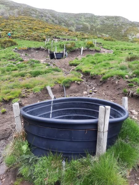
At 1449 meters above sea level, nestled in d 39, albepierre-bredons, saint-flour, cantal, auvergne-rhône-alpes, francia metropolitana, 15300, francia, stands the Buron de Salabert refuge. It is the perfect stop to spend the night or catch your breath. GPS coordinates: 45.065, 2.793.
9°C
Feels like: 6.4°C13.4 km/h
Gusts: 53.3 km/h4090 m
Snow lineUV 0
Clouds: 100% 24.1 mm
 23.3 km/h
 UV máx: 2.95
 06:03
06:03
 21:30
1.6 mm
18.7 km/h
UV máx: 7.7
06:03
21:31
0.1 mm
26.4 km/h
UV máx: 7
06:02
21:32
0 mm
8.1 km/h
UV máx: 6.9
06:02
21:32
2.85 mm
15.1 km/h
UV máx: 7.25
06:02
21:33
1.8 mm
18.7 km/h
UV máx: 7.05
06:01
21:34
0 mm
8.9 km/h
UV máx: 7.65
06:01
21:34
21:30
1.6 mm
18.7 km/h
UV máx: 7.7
06:03
21:31
0.1 mm
26.4 km/h
UV máx: 7
06:02
21:32
0 mm
8.1 km/h
UV máx: 6.9
06:02
21:32
2.85 mm
15.1 km/h
UV máx: 7.25
06:02
21:33
1.8 mm
18.7 km/h
UV máx: 7.05
06:01
21:34
0 mm
8.9 km/h
UV máx: 7.65
06:01
21:34
It is appropriate to have water autonomy before going through this free shelter : the localized sources are more than 3 km away, so it is not wise to take for granted an immediate supply next to the coat. At 1,449 metres, in the environment of the D39 and the end of the Albepierre- Breds , this donkey fits better as a step support than as a service-dependent stop.
Its position is of particular interest to those who move between the Albepierre side and the cabbage of Prat-de-Bouc , a natural link area between slopes and valleys of the Chantal massif. In that context, Buron de Salabert may be used to fail a journey or as a point of withdrawal if the weather gets worse at high levels. The proximity of the Puy de Prat de Bouc and the close reference of the Plomb du Cantal help to place it on an open, half-mountain ground, where wind and time changes can make the day very difficult.
It also makes sense within trails that link Murat, Saint-Jacques-des-Blats or the descent to Albepierre, as it is left in a stretch between routes of considerable length. There is no need to raise this as a base for summits: its main utility is to connect stages, shorten a long day or have an intermediate guard during a journey through the sector.
By profile, it is more useful for mountaineers and hikers with a certain planning capacity than for improvised exits. The altitude is not extreme, but it is enough to notice exposure, fog or fast cooling out of the friendly season. If it is to be used as a support, it is appropriate to review the access route well, to carry food and water margin, and not to depend on finding immediate resources in the vicinity.


📏 1.3 Km
⛰️ 1400 m

📏 1.4 Km
⛰️ 1300 m

📏 2.8 Km
⛰️ 1205 m

📏 3.5 Km
⛰️ 1545 m

📏 4.1 Km
⛰️ 1460 m

📏 5.7 Km
⛰️ 1250 m
📏 6.5 Km
⛰️ 1450 m
📏 7.6 Km
⛰️ 1340 m
Download the app and start looking for the shelter of your next adventure


Find a place to sleep before night falls.


