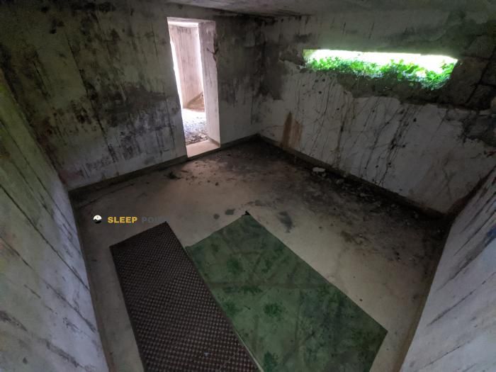
Mountain refuge Ancien corps de garde Ouest, Île de Batz
We have it listed in the app!
We have it listed in the app!
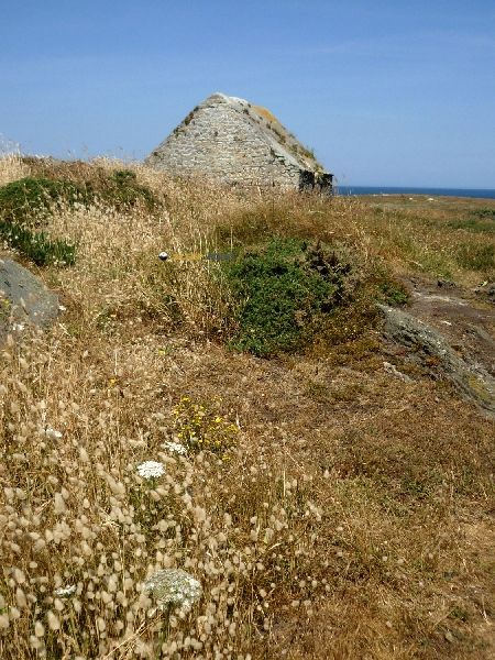

Located at 20 m above sea level, the Ancien corps de garde Ouest, Île de Batz refuge is a true haven of peace in corps de garde, kerabandu, Île-de-batz, morlaix, finisterre, bretaña, francia metropolitana, 29253, francia. Connect with nature and use its coordinates (48.743, -4.036) to guide your steps to its door.
14.6°C
Feels like: 8.6°C41.8 km/h
Gusts: 59 km/h2240 m
Snow lineUV 0
Clouds: 100% 1.95 mm
 52.1 km/h
 UV máx: 7
 06:15
06:15
 22:13
2.85 mm
37.8 km/h
UV máx: 6.35
06:15
22:14
3.5 mm
40.5 km/h
UV máx: 7.1
06:14
22:15
0 mm
23.1 km/h
UV máx: 5.8
06:14
22:15
4.8 mm
25.5 km/h
UV máx: 7.15
06:13
22:16
2.7 mm
22.2 km/h
UV máx: 6.4
06:13
22:17
3 mm
30.6 km/h
UV máx: 5.25
06:13
22:17
22:13
2.85 mm
37.8 km/h
UV máx: 6.35
06:15
22:14
3.5 mm
40.5 km/h
UV máx: 7.1
06:14
22:15
0 mm
23.1 km/h
UV máx: 5.8
06:14
22:15
4.8 mm
25.5 km/h
UV máx: 7.15
06:13
22:16
2.7 mm
22.2 km/h
UV máx: 6.4
06:13
22:17
3 mm
30.6 km/h
UV máx: 5.25
06:13
22:17
On the north coast of Britain the coast of the Ile-de-Batz defines a relief marked by the direct influence of the Atlantic. The Ancent corps of garde Ouest, Île de Batz is located in a low altitude environment above sea level. The surrounding terrain is flat but is very exposed to the dominant sea winds. The orientation in this area is simple following the coastline. It is a clear visual point of reference in the western sector of the island.
The path of great journey E9 It crosses this island territory in a longitudinal way. Various local routes such as Circuit between Terre et Mer pass through the vicinity of the building. The map shows a dense network of roads that connect to the core of Kerabandu . There are no pronounced levels of access. The firm usually alternates between compact ground trails and rocky sections by the sea.
This old guard body functions as a strategic milestone for those who travel the entire perimeter of the island. Its position facilitates the division of short walking days in this area of Finisterre French. It is a frequent place of passage in itineraries such as Perharidy Circuit . The visibility to the horizon is excellent on clear days. It serves to confirm the exact position before turning to the most protected sectors.
The planning of any route through the area should always consider the supply of drinking water. There is a fountain located about 570 meters away from the Ancent corps of garde Ouest, Île de Batz . Another supply option is located just over half a kilometre along the main paths. It is appropriate to ensure the load of liquid before continuing to go. Personal autonomy is essential for the safe passage of this coastal environment.
The changing climate of the Atlantic severely conditions the stay at this geographical point. Brumas and storms can quickly reduce the conditions of visibility on the path. There are no nearby summits that act as a parapet in front of the wind. The soil is stable although it usually has moisture due to the saline environment. This support point is useful for hiking people who explore the most exposed face of the Ile-de-Batz .


Download the app and start looking for the shelter of your next adventure


Find a place to sleep before night falls.