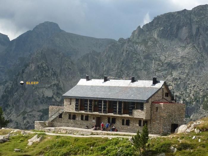
Mountain refuge Amitges
We have it listed in the app!
We have it listed in the app!


If you are looking for total disconnection, venture into camí de l'estany gran d'amitges, espot, pallars sobirá, lérida, cataluña, 25597, españa until you reach the Amitges refuge, positioned at 2380 meters. Use your device to navigate to the exact point (42.597, 0.984) to find this alpine shelter.
2.9°C
Feels like: -0.8°C8.6 km/h
Gusts: 27 km/h4490 m
Snow lineUV 0
Clouds: 99% 14.4 mm
 20.6 km/h
 UV máx: 7.3
 06:19
06:19
 21:29
1.2 mm
15.9 km/h
UV máx: 8.15
06:19
21:29
0 mm
9.8 km/h
UV máx: 7.5
06:19
21:30
0 mm
7.9 km/h
UV máx: 7.45
06:18
21:31
0.6 mm
17.6 km/h
UV máx: 8.2
06:18
21:31
0 mm
7.5 km/h
UV máx: 4.7
06:18
21:32
0 mm
8.3 km/h
UV máx: 7.95
06:18
21:33
21:29
1.2 mm
15.9 km/h
UV máx: 8.15
06:19
21:29
0 mm
9.8 km/h
UV máx: 7.5
06:19
21:30
0 mm
7.9 km/h
UV máx: 7.45
06:18
21:31
0.6 mm
17.6 km/h
UV máx: 8.2
06:18
21:31
0 mm
7.5 km/h
UV máx: 4.7
06:18
21:32
0 mm
8.3 km/h
UV máx: 7.95
06:18
21:33
In the field of Spot within the National Park of Aigüestortes i Estany de Sant Maurici, Amitges is linked to the lacustre environment of Ratera and the reservoir of Amitges, in a header of clearly pirenaica valley, modeled by glacial circles, ponds and steps of height. Its position helps to place it between the Sant Maurici basin and the hills that communicate towards Saoredo and the orange slope, in a strip where the land already has a high mountain character.
More than a simple point of passage, this shelter fits well in the planning of long journeys. It is part of the Foc Carros and can also enter into the logic of stages linked to the HRP , so it is useful to divide days, link shelters or reorganize a route if it is to avoid long down to lower levels. For those who follow several-day itineraries, their location can compensate for a deviation when the goal is to gain height for the next day or to maintain an alpine road trip.
The close emphasis reinforces that strategic role. Toward the immediate environment are summits and crests such as the Tres Puis, the Xmeneeies Pic or the Gran Tuc de Colomèrs, as well as the Saoredo saw and the Amitges peaks cited in the area. These are not just names on the map: they indicate a frame of hills, diagrams and slopes where orientation, meteorology and the state of the ground can very much condition the progression.
At 2380 meters, it is appropriate to have a cold environment out of the stable season and quick changes of time even on relatively short routes. It is also important to plan with autonomy: the registered sources are far away, more than 8 km away, so it is not appropriate to resolve the water without checking it before. If used as stage support, the decision often goes through the same thing: to value accumulated gap, weather forecast and real margin between shelters before compromising the day.


📏 0 Km
⛰️ 2380 m

📏 2.4 Km
⛰️ 2460 m

📏 2.9 Km
⛰️ 1885 m

📏 3.2 Km
⛰️ 2310 m

📏 4 Km
⛰️ 1985 m

📏 4.3 Km
⛰️ 2235m m

📏 4.4 Km
⛰️ 1984.8 m

📏 4.9 Km
⛰️ 1920 m
Download the app and start looking for the shelter of your next adventure


Find a place to sleep before night falls.


