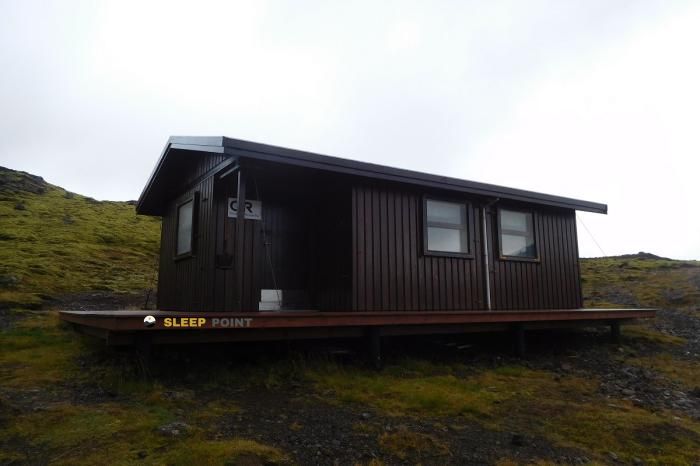
Mountain refuge Abri du Brunnavatn
We have it listed in the app!
We have it listed in the app!


Discover the Abri du Brunnavatn refuge, an alpine shelter located at 380 meters in the area of kaldadalsvegur, bláskógabyggð, suðurland, islandia. Whether you are on a multi-day trek or a day hike, this point (64.448, -20.961) will provide the peace and shelter you seek in the mountains.
5°C
Feels like: 2.2°C9.7 km/h
Gusts: 13 km/h1720 m
Snow lineUV 0.2
Clouds: 100% 0.1 mm
 32.4 km/h
 UV máx: 3.6
 03:04
03:04
 23:39
3.7 mm
28.1 km/h
UV máx: 2.35
03:02
23:42
4.72 mm
27.3 km/h
UV máx: 4.9
03:00
23:45
2.9 mm
21.7 km/h
UV máx: 4.55
02:57
23:47
7.8 mm
10.8 km/h
UV máx: 0.6
02:55
23:50
3.1 mm
14.1 km/h
UV máx: 1.85
02:53
23:52
3.7 mm
12.8 km/h
UV máx: 3.85
02:51
23:54
23:39
3.7 mm
28.1 km/h
UV máx: 2.35
03:02
23:42
4.72 mm
27.3 km/h
UV máx: 4.9
03:00
23:45
2.9 mm
21.7 km/h
UV máx: 4.55
02:57
23:47
7.8 mm
10.8 km/h
UV máx: 0.6
02:55
23:50
3.1 mm
14.1 km/h
UV máx: 1.85
02:53
23:52
3.7 mm
12.8 km/h
UV máx: 3.85
02:51
23:54
Understanding the role of Abri du Brunnavatn needs to be placed in the logic of the Icelandic highlands, where the points of support are scarce and the exposure to the climate is constant. This small room is presented as a strategic resource for those who travel through the Bláskógabyggð , offering a basic safeguard on a ground marked by the nudity of the relief and the absence of protective vegetation. Its main functionality is to serve as a safety point in a climate of high weather variability.
Its position at about 380 meters of altitude links it directly to the environment of the Kaldadalsvegur , a route that crosses volcanic and desert landscapes in the region of Suðurland . On the near horizon, just over four kilometers away, the silhouette of the Sandfell , whose elevation of 512 meters serves as a clear visual reference in an area where orientation can be quickly complicated if visibility decreases. The surrounding relief is austere, typical of the transitions into the island.
How free shelter the installation requires a high degree of commitment by the mountaineer. It is not an accommodation with services, but a technical night structure that requires rigorous prior planning. The management of the effort in this sector depends entirely on the user's load capacity, as isolation is one of the defining characteristics of this site, away from urban centres or immediate assistance centres.
The availability of water resources is the most decisive factor in considering the use of this shelter. The nearest sources are at distances exceeding 19 km, which forces any walker to carry all the water necessary for the day and stay. To trust to find immediate supplies in the vicinity is a risk that compromises security, so the autonomy water must be absolute before starting the approach.
The profile of those who use this point is usually that of a mountaineer with experience of self-sufficiency. Given the absence of long-range, beamed paths through the door, navigation with precision tools is indispensable. Maintaining the integrity of the equipment and an adequate food reserve is essential to ensure security in an area where the infrastructure is minimal and the environment does not allow logistical errors.


Download the app and start looking for the shelter of your next adventure


Find a place to sleep before night falls.