Mountain refuge Abri du bois de la Glière
We have it listed in the app!
We have it listed in the app!
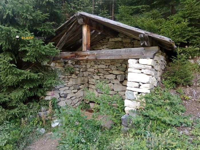

Located in the heart of route des fontanettes, fontanettes, pralognan-la-vanoise, albertville, saboya, auvergne-rhône-alpes, francia metropolitana, 73710, francia, the Abri du bois de la Glière refuge offers shelter at 1700 meters above sea level. Ideal for trekking and nature lovers, this mountain shelter (Lat: 45.383, Lon: 6.738) is the perfect starting point or resting place for local routes.
7.5°C
Feels like: 4.4°C6.1 km/h
Gusts: 9.7 km/h4030 m
Snow lineUV 0
Clouds: 100% 25.7 mm
 9.6 km/h
 UV máx: 5.95
 05:46
05:46
 21:16
2.5 mm
8.5 km/h
UV máx: 7.55
05:46
21:16
0 mm
12.3 km/h
UV máx: 8.1
05:45
21:17
0 mm
12.1 km/h
UV máx: 8.1
05:45
21:18
0.45 mm
12.5 km/h
UV máx: 8
05:45
21:19
7.5 mm
10.2 km/h
UV máx: 2.9
05:44
21:19
0 mm
10.9 km/h
UV máx: 7.75
05:44
21:20
21:16
2.5 mm
8.5 km/h
UV máx: 7.55
05:46
21:16
0 mm
12.3 km/h
UV máx: 8.1
05:45
21:17
0 mm
12.1 km/h
UV máx: 8.1
05:45
21:18
0.45 mm
12.5 km/h
UV máx: 8
05:45
21:19
7.5 mm
10.2 km/h
UV máx: 2.9
05:44
21:19
0 mm
10.9 km/h
UV máx: 7.75
05:44
21:20
Enter Pralognan-la-Vanoise and the hillsides that close access to the Vanoise massif, Abri du bois de la Glière is located at an intermediate level, about 1,700 metres, in a sector that functions as a transition between the inhabited valley and the already clearly alpine mountain. This position makes it a useful reference to focus on the ground and to divide a day into high-rise itineraries from the Fontanettes environment to more open areas of the massif.
The geographical context helps to understand its role. Pralognan is located at the door of one of the great mountain sets of the French Alps, between the Tarentaise valley and the Vanoise summits. Near the coat, reliefs like Mont Bochor They mark a first orographic step, while higher internal needles and tips announce a more severe terrain, with changes in orientation, greater exposure to time and less kind progression as the forest is left. In this type of hillside, a change of side or umbria can quite modify the thermal sensation and the state of the path.
Their practical interest is mainly in stage planning. In the vicinity they pass long routes such as the GR 55 and Via Alpina , in addition to the Grand Tour of Tarentaise, so that it can fit as a point of support within longer journeys or on days linked by the valley. It is not appropriate to interpret it as a basis for direct ascension without further information, but it is a well-placed coat for those who move on a map, links routes and needs a clear reference on the top of the access from Pralognan.
For logistics, there are relatively close sources, with one to less than 500 meters, although in mountain this does not replace the prior check on flow or accessibility according to the time. As there is no useful data on internal equipment or services, it is reasonable to raise the output with sufficient autonomy and with margin in the face of time changes. In such a long-range area, this prudence weighs more than the distance on the map.


📏 1.3 Km
⛰️ 2010 m

📏 3.5 Km
⛰️ 2590 m

📏 3.7 Km
⛰️ 2398 m

📏 4.2 Km
⛰️ 2518 m

📏 4.7 Km
⛰️ 2190 m

📏 4.9 Km
⛰️ 1710 m

📏 5.6 Km
⛰️ 1970 m

📏 6.7 Km
⛰️ 2300 m
Download the app and start looking for the shelter of your next adventure


Find a place to sleep before night falls.


