Mountain refuge Refugio Pozo de la Nieve

We have it listed in the app!


            Mountain refuge Refugio Pozo de la Nieve in refugio pozo de la nieve, ruta el pozo de la nieve pr-av 21, el tiemblo, Ávila, castilla y león, 05428, españa
Five orange stars in a horizontal row representing a five-star rating.

Refugio Pozo de la Nieve

Lat: 40.356xxx – Lon: -4.543xxx
📍 refugio pozo de la nieve, ruta el pozo de la nieve pr-av 21, el tiemblo, Ávila, castilla y león, 05428, españa
Refugio Pozo de la Nieve

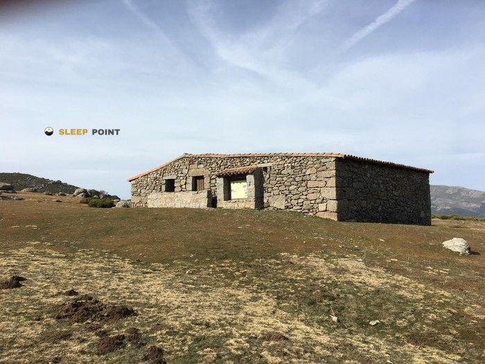
Discover the Refugio Pozo de la Nieve refuge, an alpine shelter located at 1472 meters in the area of refugio pozo de la nieve, ruta el pozo de la nieve pr-av 21, el tiemblo, Ávila, castilla y león, 05428, españa. Whether you are on a multi-day trek or a day hike, this point (40.356, -4.543) will provide the peace and shelter you seek in the mountains.

See more
See more
Usuario

Lucas Martinez

Premium user

Live weather: Refugio Pozo de la Nieve

Before heading to Refugio Pozo de la Nieve, check the weather: we currently have 15.6°C (feels like 14.2°C). With wind gusts reaching 36 km/h and a freezing level around 4670 meters, the daytime high will not exceed 22.1°C.
Temperature

15.6°C

Feels like: 14.2°C
Wind

7.7 km/h

Gusts: 36 km/h
Freezing level 0°

4670 m

Snow line
Sky & UV

UV 0

Clouds: 1%

Next 48 hours evolution

7-day forecast

04/06
22.1° 10.9°
0 mm 19.6 km/h UV máx: 7.5
06:49 21:44
05/06
21.7° 7.1°
0 mm 13.2 km/h UV máx: 8.15
06:48 21:44
06/06
24.3° 10.6°
0 mm 10.5 km/h UV máx: 7.05
06:48 21:45
07/06
26.2° 13.8°
0 mm 12.3 km/h UV máx: 8.1
06:48 21:45
08/06
26.7° 14.3°
0 mm 17.1 km/h UV máx: 8.3
06:48 21:46
09/06
27.7° 13.5°
0 mm 10.7 km/h UV máx: 7.8
06:47 21:47
10/06
28.7° 14.7°
0 mm 12.3 km/h UV máx: 7.8
06:47 21:47

Location in the Iruelas Valley

The Refugio Pozo de la Nieve is located on the northern side of the Sierra de Gredos, within the protected perimeter of the Natural Reserve of the Iruelas Valley. At an altitude of 1472 metres, the construction is integrated into a half-mountain environment that serves as a transition to the summits of the eastern end of the Central System. The surrounding relief is defined by the proximity of the Alto del Mirlo and Cerro de la Encinilla, which allows a clear reading of the ground for those who travel the cords that separate the valleys of El Tiemblo and Casillas.

Logistics and access routes

The approach is based mainly on the route route PR-AV 21, a route that requires adequate effort management according to weather conditions. Its location is strategic to connect with the GR 180 to the Tiétar Valley or to make ascension to the nearby peaks that exceed 1700 meters. In terms of resource management, a source is located about 600 metres from the shelter, although water autonomy is essential before the rise begins. In the absence of internal care and services, the use of this free shelter requires complete self-sufficiency and equipment prepared for the exposure of the abulian saw.

Hiking routes from the refuge

GR 180

Valle del Tiétar

↔ 207 km

Nearby peaks

Venerillo Sierro

1326 m
Lat: 40.3699 Lon: -4.4875

Cerro de Pinosequillo

1759 m
Lat: 40.3457 Lon: -4.5939

Cerro de la Encinilla

1601 m
Lat: 40.3642 Lon: -4.5379

Cabeza de la Parra

1639 m
Lat: 40.3928 Lon: -4.5395

Cerro Monteagudo

1188 m
Lat: 40.3966 Lon: -4.5869

Alto del Mirlo o Pico Casillas

1767 m
Lat: 40.3443 Lon: -4.5501

La Cabeza

825 m
Lat: 40.3293 Lon: -4.4954

Cerro de las Cabezuelas

845 m
Lat: 40.3437 Lon: -4.4856

Nearby water fountains

Fuente

622 m
Lat: 40.3437 Lon: -4.4856

El Puerto

3.23 Km
Lat: 40.3437 Lon: -4.4856

Los Bañaderos

4.23 Km
Lat: 40.3437 Lon: -4.4856

Fuente

4.24 Km
Lat: 40.3437 Lon: -4.4856

El Camocho

4.77 Km
Lat: 40.3437 Lon: -4.4856

Fuente

5.28 Km
Lat: 40.3437 Lon: -4.4856

Fuente

5.34 Km
Lat: 40.3437 Lon: -4.4856

Fuente

5.94 Km
Lat: 40.3437 Lon: -4.4856
FAQ

Frequently asked questions

Pregunta frecuente
What are the GPS coordinates of the Refugio Pozo de la Nieve refuge?
To locate the Refugio Pozo de la Nieve refuge on your GPS or map, use the following coordinates: Latitude 40.356 and Longitude -4.543.
Pregunta frecuente
Is it necessary to carry a GPS to reach the Refugio Pozo de la Nieve refuge?
It is always highly recommended to carry a GPS device, a route track, or a topographic map in the mountains. You can use the coordinates 40.356, -4.543 to locate this refuge precisely.
Pregunta frecuente
In which municipality or region is the Refugio Pozo de la Nieve refuge located?
This refuge is located within the municipality of El Tiemblo, belonging to the community or region of Castilla y León.
More areas

Other areas

Collaborative

Together we improve

image

Send your photos

You can upload photos of shelters and update their status so other users know if they can go there.

Get started
Get started
image

Rate the shelter

Leave your comments to rate the shelter’s condition. In the mountains, we look after each other.

Get started
Get started
image

Add new ones

Did we miss any? Publish the shelters you know so everyone can use them.

Get started
Get started
Download for free from the Apple App Store and Play Store.

Download the app and start looking for the shelter of your next adventure

Aplicación móvil para encontrar refugios de montaña donde dormir
Aplicación móvil para encontrar refugios de montaña donde dormir.
Mapa interactivo de refugios de montaña en los Pirineos dentro de la app
Mapa de refugios de montaña para senderismo y trekking en la app.
Pantalla con información de refugio de montaña con altitud capacidad y servicios
Pantalla con información de refugio de montaña con altitud capacidad y servicios.
Detalles de refugio de montaña con servicios y meteorología en aplicación móvil
Detalles de refugio de montaña con servicios y meteorología en aplicación móvil.
Aplicación para explorar refugios de montaña mediante mapa interactivo
Aplicación para explorar refugios de montaña mediante mapa interactivo.
Ficha completa de refugio de montaña con opiniones y servicios
Ficha completa de refugio de montaña con opiniones y servicios.
Información detallada de refugio en app para montañeros
Información detallada de refugio en app para montañeros.
Listado de refugios de montaña para senderismo y trekking
Listado de refugios de montaña para senderismo y trekking.
Explorar refugios de montaña desde una aplicación móvil
Explorar refugios de montaña desde una aplicación móvil.