Mountain refuge Refugio Armañon
We have it listed in the app!
We have it listed in the app!


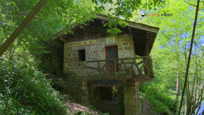
The Refugio Armañon refuge (refugio armañon, senda de los jorrios (pr-bi 120), trucios, vizcaya, país vasco, 39880, españa) is a classic meeting point for mountaineers and hikers. At 761 meters, its coordinates 43.278, -3.313 mark the end of a stage or the beginning of a new adventure.
12.6°C
Feels like: 12.4°C6.6 km/h
Gusts: 15.1 km/h4190 m
Snow lineUV 0
Clouds: 100% 8.22 mm
 24.1 km/h
 UV máx: 0.85
 06:34
06:34
 21:48
6.2 mm
12.2 km/h
UV máx: 6.55
06:34
21:49
0 mm
14.6 km/h
UV máx: 4.1
06:33
21:50
0 mm
9.7 km/h
UV máx: 7.55
06:33
21:50
1.5 mm
12.6 km/h
UV máx: 7.3
06:33
21:51
1.5 mm
10 km/h
UV máx: 7.35
06:33
21:52
0 mm
10.8 km/h
UV máx: 7.4
06:32
21:52
21:48
6.2 mm
12.2 km/h
UV máx: 6.55
06:34
21:49
0 mm
14.6 km/h
UV máx: 4.1
06:33
21:50
0 mm
9.7 km/h
UV máx: 7.55
06:33
21:50
1.5 mm
12.6 km/h
UV máx: 7.3
06:33
21:51
1.5 mm
10 km/h
UV máx: 7.35
06:33
21:52
0 mm
10.8 km/h
UV máx: 7.4
06:32
21:52
The region of Las Encartaciones, on the western end of Vizcaya, houses an abrupt relief where the Natural Park of Armañón it stands out for its karmic landscape and its complex orography. In this environment of Valley of Trucios , the land is characterized by pronounced slopes and a network of trails that connect the Cantabria coast with the mountains of the interior. The presence of a support point at these heights becomes relevant when the fog or sudden changes in the cantabrian climate complicate the orientation in the cords that separate the vizcain lands from the cantabra.
For those who travel the GR 123 or Bizkaiko bita , this installation functions as a strategic reference within a long-run journey that surrounds the entire province. Its location allows to manage the stages that pass through the massif, offering a place of transition or technical stop before facing the most exposed sections of the division. It is directly linked to small trails such as PR-BI 120 (The ibilbidea Horrios) and the PR-BI 121 , which explore the mining and mining past of the area.
The closeness to summits like The Parapets located within walking distance, it defines its mountain character despite being at an altitude of 761 metres. From this point of view, access to other relevant elevations such as Surbs , High sludges or Pico de las Nieves , forming a circus of tops that requires constant attention to the stony terrain. The technicality of the limestone soil in certain sectors makes this space a valuable resource to restructure a route or seek protection if the maritime front enters quickly.
The logistics in this sector of Basque Country It requires careful planning, especially with regard to water supply. Since the nearest permanent sources are located several kilometres away and at different levels, the mountain must maintain strict autonomy. The lack of immediate water points makes it necessary to carry sufficient liquid from the bottom of the valley in Truths or from known points in the lower areas of the natural park. This factor conditions the use of the shelter more as a point of passage or emergency than as a basis for long stays without external support.
In the event of forced withdrawal by physical fatigue or adverse weather, the descent to the urban nuclei of the valley is the most logical escape route. The transition from the high cords to the most protected forest areas provides a safe space for those who are surprised by persistent brumas or typical thermal variations on the northern side. Understanding this point as a tactical element within the network of The Encartations is essential for any senderist who seeks to complete the traverses of the area with a safety and foresight approach.


📏 10.2 Km
⛰️ 816 m
📏 10.6 Km
⛰️ 69 m

📏 25.5 Km
⛰️ 1031 m

📏 28.8 Km
⛰️ 1154 m

📏 30.1 Km
⛰️ 664 m

📏 32.4 Km
⛰️ 1061 m

📏 34.5 Km
⛰️ 1064 m

📏 35 Km
⛰️ 782 m
Download the app and start looking for the shelter of your next adventure


Find a place to sleep before night falls.


