Mountain refuge Refuge l'Espace

We have it listed in the app!


            Mountain refuge Refuge l'Espace in refuge l'espace, route de la tour, godet, conthey, vallés, 1964, suiza
Five orange stars in a horizontal row representing a five-star rating.

Refuge l'Espace

Lat: 46.31xxx – Lon: 7.224xxx
📍 refuge l'espace, route de la tour, godet, conthey, vallés, 1964, suiza
Refuge l'Espace

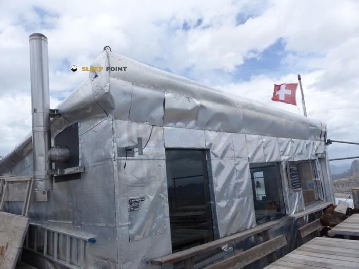
Located at 2860 m above sea level, the Refuge l'Espace refuge is a true haven of peace in refuge l'espace, route de la tour, godet, conthey, vallés, 1964, suiza. Connect with nature and use its coordinates (46.31, 7.224) to guide your steps to its door.

See more
See more
Usuario

Lucas Martinez

Premium user

Live weather: Refuge l'Espace

Live weather report for Refuge l'Espace: current 2.1°C at 2860 meters (feels like -1.6°C). Wind at 6.6 km/h with gusts that may reach 25.2 km/h. The freezing level is at 3730 m and the maximum temperature will be 3.7°C.
Temperature

2.1°C

Feels like: -1.6°C
Wind

6.6 km/h

Gusts: 25.2 km/h
Freezing level 0°

3730 m

Snow line
Sky & UV

UV 0

Clouds: 99%

Next 48 hours evolution

7-day forecast

04/06
3.7° -2.5°
22.5 mm 20.3 km/h UV máx: 6.6
05:41 21:17
05/06
0.9° -3.3°
3.6 mm 13.6 km/h UV máx: 3.9
05:40 21:18
06/06
9.6° 0.8°
0.3 mm 17.3 km/h UV máx: 6.95
05:40 21:19
07/06
11° 2.4°
0 mm 8.4 km/h UV máx: 7.35
05:39 21:20
08/06
12.8° 4.1°
2.25 mm 13.7 km/h UV máx: 6.4
05:39 21:20
09/06
6.3° -0.3°
6.3 mm 16.5 km/h UV máx: 2.35
05:39 21:21
10/06
10.3° -1.8°
0 mm 11.5 km/h UV máx: 7.5
05:38 21:22

The ground here quickly changes between high slopes, rocky highlights and crest environment, in a very exposed strip of the Vallés , on the municipality of Conthey. At 2,860 metres, the environment of the shelter is already moving in a clearly alpine height, near the massif of Les Diablerets and reliefs where the rock dominates any smooth transition.

Refuge l'Espace is very close to the Quille du Diable ou Tour Saint-Martin , practically on top of the shelter, and also close to tops like Le Dôme des Diablerets , Oldehore or Scex Rouge . This position helps to understand its function: not so much as a valley coat, but as a support on high ground, useful to divide days or to raise ascent and links by close cords and hills.

Access requires a good management of the effort. In this type of location, the approach often goes from more friendly terrain to stony and open areas, with greater exposure to the wind and rapid changes in time. That is why it is necessary to decide in advance whether it will be used as a basis for moving through nearby summits or as a point of passage within a longer journey.

Its position fits with itineraries of greater route like the Tour des Muverans or Via Alpina , although the real interest of the shelter depends on the route chosen and how the height steps of the sector are linked. In such an area, the orientation and state of the land weigh more than the simple distance on the map.

As a free haven on high mountain, he calls for autonomy. There are no immediate sources next to the building and the nearest ones are several kilometres away, so the water must be provided before the rise. It is also appropriate to have margin against changing weather and not to take for granted any additional service beyond its basic coat function.

Hiking routes from the refuge

Local

Tour des Muverans

↔ Variable distance
Local

Petit bisse

↔ Variable distance
Local

Bisse de la Tsandra

↔ Variable distance
Local

Tour du Wildhorn

↔ Variable distance
82

Sanetsch-Muveran-Weg

↔ 42 km
ehem. VA-R104

Via Alpina Red R104

↔ Variable distance
Local

Sentier de découverte géographique

↔ Variable distance
Local

Tour de la vallée de Derborence

↔ Variable distance

Nearby peaks

Scex Rouge

2971 m
Lat: 46.3272 Lon: 7.2024

Quille du Diable ou Tour Saint-Martin

2908 m
Lat: 46.3095 Lon: 7.2247

La Fava

2612 m
Lat: 46.3021 Lon: 7.2796

Oldehore

3123 m
Lat: 46.3293 Lon: 7.2215

Le Dôme des Diablerets

2996 m
Lat: 46.314 Lon: 7.2055

Tête Ronde

3037 m
Lat: 46.3038 Lon: 7.1776

Mont à Cavouère

2612 m
Lat: 46.2585 Lon: 7.2145

Tour d'Anzeinde

2169 m
Lat: 46.2838 Lon: 7.1557

Nearby water fountains

Fuente

5.6 Km
Lat: 46.2838 Lon: 7.1557

Fuente

5.86 Km
Lat: 46.2838 Lon: 7.1557

Fuente

6.36 Km
Lat: 46.2838 Lon: 7.1557

Fuente

6.82 Km
Lat: 46.2838 Lon: 7.1557

Fuente

6.9 Km
Lat: 46.2838 Lon: 7.1557

Fuente

6.92 Km
Lat: 46.2838 Lon: 7.1557

Fuente

7.12 Km
Lat: 46.2838 Lon: 7.1557

Fuente

7.24 Km
Lat: 46.2838 Lon: 7.1557
FAQ

Frequently asked questions

Pregunta frecuente
Is it necessary to carry a GPS to reach the Refuge l'Espace refuge?
It is always highly recommended to carry a GPS device, a route track, or a topographic map in the mountains. You can use the coordinates 46.31, 7.224 to locate this refuge precisely.
Pregunta frecuente
In which municipality or region is the Refuge l'Espace refuge located?
This refuge is located within the municipality of Conthey, belonging to the community or region of Vallés.
Pregunta frecuente
Are there other mountain refuges near Refuge l'Espace?
Yes, nearby you can find other options to spend the night or take shelter. El refugio más próximo es el Cabane de Prarochet, que se encuentra a aproximadamente 1.9 km de distancia.
More areas

Other areas

Collaborative

Together we improve

image

Send your photos

You can upload photos of shelters and update their status so other users know if they can go there.

Get started
Get started
image

Rate the shelter

Leave your comments to rate the shelter’s condition. In the mountains, we look after each other.

Get started
Get started
image

Add new ones

Did we miss any? Publish the shelters you know so everyone can use them.

Get started
Get started
Download for free from the Apple App Store and Play Store.

Download the app and start looking for the shelter of your next adventure

Aplicación móvil para encontrar refugios de montaña donde dormir
Aplicación móvil para encontrar refugios de montaña donde dormir.
Mapa interactivo de refugios de montaña en los Pirineos dentro de la app
Mapa de refugios de montaña para senderismo y trekking en la app.
Pantalla con información de refugio de montaña con altitud capacidad y servicios
Pantalla con información de refugio de montaña con altitud capacidad y servicios.
Detalles de refugio de montaña con servicios y meteorología en aplicación móvil
Detalles de refugio de montaña con servicios y meteorología en aplicación móvil.
Aplicación para explorar refugios de montaña mediante mapa interactivo
Aplicación para explorar refugios de montaña mediante mapa interactivo.
Ficha completa de refugio de montaña con opiniones y servicios
Ficha completa de refugio de montaña con opiniones y servicios.
Información detallada de refugio en app para montañeros
Información detallada de refugio en app para montañeros.
Listado de refugios de montaña para senderismo y trekking
Listado de refugios de montaña para senderismo y trekking.
Explorar refugios de montaña desde una aplicación móvil
Explorar refugios de montaña desde una aplicación móvil.