Mountain refuge La Traverse

We have it listed in the app!


            Mountain refuge La Traverse in la traverse, 2, rue traversière, le bessat, saint-Étienne, loira, auvergne-rhône-alpes, francia metropolitana, 42660, francia
Five orange stars in a horizontal row representing a five-star rating.

La Traverse

Lat: 45.369xxx – Lon: 4.514xxx
📍 la traverse, 2, rue traversière, le bessat, saint-Étienne, loira, auvergne-rhône-alpes, francia metropolitana, 42660, francia
La Traverse

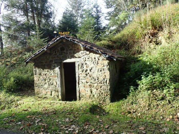
The La Traverse refuge (la traverse, 2, rue traversière, le bessat, saint-Étienne, loira, auvergne-rhône-alpes, francia metropolitana, 42660, francia) is a classic meeting point for mountaineers and hikers. At 1173 meters, its coordinates 45.369, 4.514 mark the end of a stage or the beginning of a new adventure.

See more
See more
Usuario

Lucas Martinez

Premium user

Live weather: La Traverse

At 1173 meters, the area around La Traverse records 10.4°C with 100% cloud cover and a UV index of 0. The temperature will peak at 12.9°C today, with winds of 5.4 km/h and a freezing level of 4070 m.
Temperature

10.4°C

Feels like: 9.1°C
Wind

5.4 km/h

Gusts: 20.2 km/h
Freezing level 0°

4070 m

Snow line
Sky & UV

UV 0

Clouds: 100%

Next 48 hours evolution

7-day forecast

04/06
12.9° 8.8°
17.2 mm 17.7 km/h UV máx: 1.85
05:55 21:24
05/06
12.4° 5.7°
1.2 mm 15.6 km/h UV máx: 7.4
05:55 21:25
06/06
19.2° 8.6°
0.2 mm 18.2 km/h UV máx: 7.3
05:54 21:26
07/06
18.1°
0 mm 7.9 km/h UV máx: 7
05:54 21:27
08/06
21° 11.8°
7.95 mm 7.6 km/h UV máx: 7
05:54 21:27
09/06
15.3° 9.8°
1.2 mm 15.2 km/h UV máx: 4.75
05:53 21:28
10/06
17.7° 6.8°
0 mm 11.4 km/h UV máx: 7.5
05:53 21:29

At 1,173 metres, The Traverse is located in the high strip of Le Bessat , inside the massif of Pilat , in a relief of loins, rounded peaks and forests exposed to the wind. It does not respond to the isolated model of a high-mountain pyrenaica, but it does perform a clear support function in medium-altitude mountain terrain, where meteorology can change quickly and fog or cold add demand even on routes without great heights. In their near environment they highlight alignments such as Crêt de la Perdrix , Crêt de la Chèvre or Crêt de l'Arnica useful references to understand the general orientation of the sector and the open nature of the crest.

His interest is mainly in transit. The presence of long-distance itineraries such as GR 7 and GR 42 It makes it a point of support to divide days, reorganize a journey or propose a retreat to an inhabited area if time gets worse. It also fits into hiking exits on the Pilat with circular tours or links between hills and crest, rather than as a basis for technical ascension. For those who travel long stages, their position near a core like Le Bessat provides a transition between mountain and valley services, something useful when you need to adjust logistics without leaving the entire road.

It is appropriate to plan on a mountain basis. There is a source about 1.23 km, reasonable distance to complete water, but it does not replace the need to check the actual availability before leaving. The area combines comfortable sections with sectors exposed to wind, humidity and changing visibility, especially in divisives and high tracks. So, The Traverse It is more useful as a shelter or a point of support within a itinerary by the Pilat than as a destination in itself: a functional place of passage for trails that move between crest, forests and long routes of the eastern sector of the Central Massif.

Hiking routes from the refuge

GR 42

De Saint-Étienne au Grau-du-Roi

↔ 452 km
Local

Sentier du Parc 3

↔ Variable distance
2

Pilat Nº2: Bourg-Argental - Le Grand Bois

↔ 26.5 km
23

Pilat N°23 : circuit « des barrages »

↔ 25 km
GR 7

Des Vosges aux Pyrénées 03, La Vaseraie - Signal du Ventalon

↔ 586 km
4

Sentier Claude Berthier

↔ 48.5 km
3

Les Menhirs de Gimel

↔ Variable distance
5

Chaussitre

↔ Variable distance

Nearby peaks

Crêt de la Perdrix

1432 m
Lat: 45.3825 Lon: 4.5728

Crêt de la Chèvre

1427 m
Lat: 45.3794 Lon: 4.5813

Crêt de l'Airellier

1329 m
Lat: 45.374 Lon: 4.587

Crêt de l'Arnica

1429 m
Lat: 45.3809 Lon: 4.5813

Le Sapey

1100 m
Lat: 45.4075 Lon: 4.4796

Nearby water fountains

Fuente

1.23 Km
Lat: 45.4075 Lon: 4.4796

Fuente

5.08 Km
Lat: 45.4075 Lon: 4.4796

Fuente

7.05 Km
Lat: 45.4075 Lon: 4.4796

Fuente

7.41 Km
Lat: 45.4075 Lon: 4.4796

Fuente

7.5 Km
Lat: 45.4075 Lon: 4.4796

Fuente

8.59 Km
Lat: 45.4075 Lon: 4.4796

Fuente

8.87 Km
Lat: 45.4075 Lon: 4.4796

Fuente

9.32 Km
Lat: 45.4075 Lon: 4.4796
FAQ

Frequently asked questions

Pregunta frecuente
What are the GPS coordinates of the La Traverse refuge?
To locate the La Traverse refuge on your GPS or map, use the following coordinates: Latitude 45.369 and Longitude 4.514.
Pregunta frecuente
Is it necessary to carry a GPS to reach the La Traverse refuge?
It is always highly recommended to carry a GPS device, a route track, or a topographic map in the mountains. You can use the coordinates 45.369, 4.514 to locate this refuge precisely.
Pregunta frecuente
In which municipality or region is the La Traverse refuge located?
This refuge is located within the municipality of Le Bessat, belonging to the community or region of Auvergne-Rhône-Alpes.
More areas

Other areas

Collaborative

Together we improve

image

Send your photos

You can upload photos of shelters and update their status so other users know if they can go there.

Get started
Get started
image

Rate the shelter

Leave your comments to rate the shelter’s condition. In the mountains, we look after each other.

Get started
Get started
image

Add new ones

Did we miss any? Publish the shelters you know so everyone can use them.

Get started
Get started
Download for free from the Apple App Store and Play Store.

Download the app and start looking for the shelter of your next adventure

Aplicación móvil para encontrar refugios de montaña donde dormir
Aplicación móvil para encontrar refugios de montaña donde dormir.
Mapa interactivo de refugios de montaña en los Pirineos dentro de la app
Mapa de refugios de montaña para senderismo y trekking en la app.
Pantalla con información de refugio de montaña con altitud capacidad y servicios
Pantalla con información de refugio de montaña con altitud capacidad y servicios.
Detalles de refugio de montaña con servicios y meteorología en aplicación móvil
Detalles de refugio de montaña con servicios y meteorología en aplicación móvil.
Aplicación para explorar refugios de montaña mediante mapa interactivo
Aplicación para explorar refugios de montaña mediante mapa interactivo.
Ficha completa de refugio de montaña con opiniones y servicios
Ficha completa de refugio de montaña con opiniones y servicios.
Información detallada de refugio en app para montañeros
Información detallada de refugio en app para montañeros.
Listado de refugios de montaña para senderismo y trekking
Listado de refugios de montaña para senderismo y trekking.
Explorar refugios de montaña desde una aplicación móvil
Explorar refugios de montaña desde una aplicación móvil.