Mountain refuge Grotte des gorges de la Sirène

We have it listed in the app!


            Mountain refuge Grotte des gorges de la Sirène in cabane perchée des gorges de la sirène, d 67e2, pellier, charcier, lons-le-saunier, jura, borgoña-franco condado, francia metropolitana, 39130, francia
Five orange stars in a horizontal row representing a five-star rating.

Grotte des gorges de la Sirène

Lat: 46.616xxx – Lon: 5.769xxx
📍 cabane perchée des gorges de la sirène, d 67e2, pellier, charcier, lons-le-saunier, jura, borgoña-franco condado, francia metropolitana, 39130, francia
Grotte des gorges de la Sirène

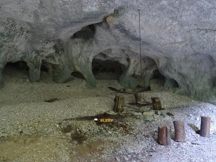
Located in the heart of cabane perchée des gorges de la sirène, d 67e2, pellier, charcier, lons-le-saunier, jura, borgoña-franco condado, francia metropolitana, 39130, francia, the Grotte des gorges de la Sirène refuge offers shelter at 558 meters above sea level. Ideal for trekking and nature lovers, this mountain shelter (Lat: 46.616, Lon: 5.769) is the perfect starting point or resting place for local routes.

See more
See more
Usuario

Lucas Martinez

Premium user

Live weather: Grotte des gorges de la Sirène

If you plan to go up today to 558 m at Grotte des gorges de la Sirène, you will find 12.9°C with a feels-like temperature of 11.8°C. The freezing level is at 3790 m. The forecast shows steady winds of 4.6 km/h and peaks of 14 km/h. A high of 17.2°C is expected.
Temperature

12.9°C

Feels like: 11.8°C
Wind

4.6 km/h

Gusts: 14 km/h
Freezing level 0°

3790 m

Snow line
Sky & UV

UV 0

Clouds: 95%

Next 48 hours evolution

7-day forecast

04/06
17.2° 12.2°
10.5 mm 16.2 km/h UV máx: 4.65
05:45 21:25
05/06
16.5° 10.1°
0 mm 10.1 km/h UV máx: 6.75
05:45 21:25
06/06
20.7° 8.9°
0 mm 17.4 km/h UV máx: 7.25
05:44 21:26
07/06
20.4° 11.5°
0 mm 6.8 km/h UV máx: 5.95
05:44 21:27
08/06
23.4° 8.9°
2.85 mm 10.6 km/h UV máx: 6.35
05:44 21:28
09/06
17.9° 12.5°
18 mm 12.3 km/h UV máx: 6.6
05:43 21:28
10/06
21.9° 7.6°
0 mm 10.2 km/h UV máx: 7.05
05:43 21:29

The main reference here is not both the altitude and the type of site: a cavity or coat linked to the gorges de la Sirène in the environment of Charcier inside the department of the Jura. At 558 meters, it does not respond to the high-mountain pirenaica shelter pattern, but it can perform a clear support function in broken, wooded and attached terrain, where map reading and precise identification of the relief gain importance. In an area of nearby throats, highlights and lomas, it is appropriate to interpret the position of the coat with respect to tracks, secondary roads and local trails before having it as the only point of protection.

Its mountain interest is more related to the orientation and management of the route than to great ascension. In the vicinity are reliefs such as Le Molard, Sur Grimont or le Châtelard, which help to understand the landscape of small heights and dorsal in the sector. It also passes close to a network of hiking itineraries such as Tour du Lac, La Queille or the return to Lac de Vouglans so that this coat can fit as an intermediate reference in variable days, especially if you travel the Jura with your own navigation and without depending on a saved infrastructure. In this context, the value of the place is to serve as a recognizable point within a field where direction changes and the settings can disorient more than its altitude suggests.

Autonomy remains important. The invented sources are several kilometres away, with the nearest one around 4.7 km, so it is not appropriate to take the water for granted in the vicinity. In wet or cold days, the attached character of the throats can accentuate the feeling of fresh and slippery terrain, while with rain the progression can be complicated in steps of rock, mud or narrow path. For this reason, rather than thinking of this point as a simple occasional coat, it is useful to consider it a reference of navigation within the Jurasian massif, where the approach effort and the basic logistics must be resolved with margin.

Hiking routes from the refuge

Local

Tour du Lac

↔ Variable distance
Local

La Queille

↔ Variable distance
Local

Tour du Lac de Vouglans

↔ 82.7 km

Nearby peaks

le Châtelard

Altitude not available
Lat: 46.5929 Lon: 5.8017

Sur Grimont

Altitude not available
Lat: 46.6034 Lon: 5.8102

Le Molard

Altitude not available
Lat: 46.632 Lon: 5.7878

Sur Chatenaillot Chevry

Altitude not available
Lat: 46.6539 Lon: 5.8105

Sur Chatenaillot Chalain

Altitude not available
Lat: 46.6578 Lon: 5.8178

Mont Marcet

Altitude not available
Lat: 46.6413 Lon: 5.714

Mont Saint-Sorlin

Altitude not available
Lat: 46.6311 Lon: 5.7269

Nearby water fountains

Fuente

4.7 Km
Lat: 46.6311 Lon: 5.7269

Fuente

4.9 Km
Lat: 46.6311 Lon: 5.7269

Fuente

4.97 Km
Lat: 46.6311 Lon: 5.7269

Fuente

5.02 Km
Lat: 46.6311 Lon: 5.7269

Fuente

5.08 Km
Lat: 46.6311 Lon: 5.7269

Fuente

5.25 Km
Lat: 46.6311 Lon: 5.7269

Fuente

5.63 Km
Lat: 46.6311 Lon: 5.7269

Fuente

5.65 Km
Lat: 46.6311 Lon: 5.7269
FAQ

Frequently asked questions

Pregunta frecuente
What are the GPS coordinates of the Grotte des gorges de la Sirène refuge?
To locate the Grotte des gorges de la Sirène refuge on your GPS or map, use the following coordinates: Latitude 46.616 and Longitude 5.769.
Pregunta frecuente
Is it necessary to carry a GPS to reach the Grotte des gorges de la Sirène refuge?
It is always highly recommended to carry a GPS device, a route track, or a topographic map in the mountains. You can use the coordinates 46.616, 5.769 to locate this refuge precisely.
Pregunta frecuente
In which municipality or region is the Grotte des gorges de la Sirène refuge located?
This refuge is located within the municipality of Charcier, belonging to the community or region of Borgoña-Franco Condado.
More areas

Other areas

Collaborative

Together we improve

image

Send your photos

You can upload photos of shelters and update their status so other users know if they can go there.

Get started
Get started
image

Rate the shelter

Leave your comments to rate the shelter’s condition. In the mountains, we look after each other.

Get started
Get started
image

Add new ones

Did we miss any? Publish the shelters you know so everyone can use them.

Get started
Get started
Download for free from the Apple App Store and Play Store.

Download the app and start looking for the shelter of your next adventure

Aplicación móvil para encontrar refugios de montaña donde dormir
Aplicación móvil para encontrar refugios de montaña donde dormir.
Mapa interactivo de refugios de montaña en los Pirineos dentro de la app
Mapa de refugios de montaña para senderismo y trekking en la app.
Pantalla con información de refugio de montaña con altitud capacidad y servicios
Pantalla con información de refugio de montaña con altitud capacidad y servicios.
Detalles de refugio de montaña con servicios y meteorología en aplicación móvil
Detalles de refugio de montaña con servicios y meteorología en aplicación móvil.
Aplicación para explorar refugios de montaña mediante mapa interactivo
Aplicación para explorar refugios de montaña mediante mapa interactivo.
Ficha completa de refugio de montaña con opiniones y servicios
Ficha completa de refugio de montaña con opiniones y servicios.
Información detallada de refugio en app para montañeros
Información detallada de refugio en app para montañeros.
Listado de refugios de montaña para senderismo y trekking
Listado de refugios de montaña para senderismo y trekking.
Explorar refugios de montaña desde una aplicación móvil
Explorar refugios de montaña desde una aplicación móvil.