Mountain refuge Chalet des Founès
We have it listed in the app!
We have it listed in the app!


Strategically located in chalet des founès, chemin de la noiregoutte, bussang, Épinal, vosgos, gran este, francia metropolitana, 88540, francia, the Chalet des Founès refuge makes exploring the area easier. At 841 meters above sea level, this point of interest (47.87, 6.854) is a vital resource when planning your route.
12.8°C
Feels like: 10.4°C12.4 km/h
Gusts: 30.6 km/h3580 m
Snow lineUV 0
Clouds: 90% 17.4 mm
 22.9 km/h
 UV máx: 4.95
 05:36
05:36
 21:25
0.7 mm
14.8 km/h
UV máx: 6.6
05:35
21:26
0.3 mm
15.5 km/h
UV máx: 7.05
05:35
21:27
0 mm
14.9 km/h
UV máx: 6.2
05:34
21:28
4.05 mm
9 km/h
UV máx: 6.45
05:34
21:28
15.9 mm
17.5 km/h
UV máx: 6.5
05:34
21:29
0 mm
8.7 km/h
UV máx: 6.85
05:33
21:30
21:25
0.7 mm
14.8 km/h
UV máx: 6.6
05:35
21:26
0.3 mm
15.5 km/h
UV máx: 7.05
05:35
21:27
0 mm
14.9 km/h
UV máx: 6.2
05:34
21:28
4.05 mm
9 km/h
UV máx: 6.45
05:34
21:28
15.9 mm
17.5 km/h
UV máx: 6.5
05:34
21:29
0 mm
8.7 km/h
UV máx: 6.85
05:33
21:30
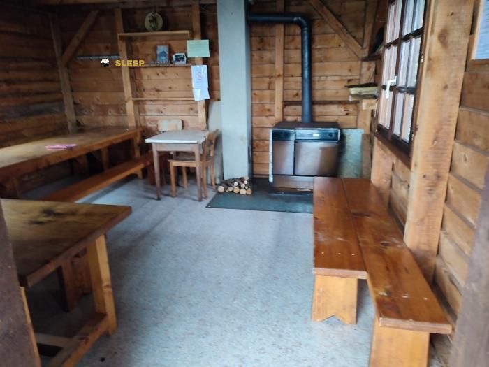
In the field of Bussang , within the massif of the Vosgos and in the French region of Gran Este, Chalet des Founès It fits as a free shelter for half-mountain days where you should read the map and the foresight. Its position brings it closer to continuity routes, with the passage of GR 5 and GR 7 in the environment, so that it can serve both to fail a journey and to solve a stage with changing weather, something common in rounded cords but exposed to wind, fog and humidity.
At 841 metres, it is not a high Alpine mountain site, but it is a point where planning remains important. In this area the effort does not depend only on the level of the gap: they also count the wooded sections, the possible lack of visibility and the linking of local roads with long-range signposted routes. For a day with autonomy, the most useful data is the presence of a relatively close source, La Fontaine a Jeannot , located about 820 meters. Even so, water should not be considered safe without checking recent conditions, especially if there is a long way out or a night in the shelter.
From here the mountain character of the sector is well understood by the closeness of tops like the Tête de la Bouloie and Ballon d'Alsace , references that help place the villa within a relief of lomas, heads and links between valleys. More than as a basis for technical ascension, its usefulness seems to be to offer logistical shelter within a network of roads where time can force shorten, divide or rethink the day. It is therefore reasonable to reach with margin, safe water and sufficient material for rapid temperature and humidity changes.


📏 0.8 Km
⛰️ 860 m

📏 1.3 Km
⛰️ 1166 m

📏 1.5 Km
⛰️ 915 m

📏 1.9 Km
⛰️ 1122 m

📏 2 Km
⛰️ 920 m
📏 2.2 Km
⛰️ 815 m

📏 2.5 Km
⛰️ 875 m

📏 3 Km
⛰️ 1000 m
Download the app and start looking for the shelter of your next adventure


Find a place to sleep before night falls.


