Mountain refuge Chalet de Bélué

We have it listed in the app!


            Mountain refuge Chalet de Bélué in chalet de bélué, les cherrières, rupt-sur-moselle, Épinal, vosgos, gran este, francia metropolitana, 88360, francia
Five orange stars in a horizontal row representing a five-star rating.

Chalet de Bélué

Lat: 47.929xxx – Lon: 6.69xxx
📍 chalet de bélué, les cherrières, rupt-sur-moselle, Épinal, vosgos, gran este, francia metropolitana, 88360, francia
Chalet de Bélué

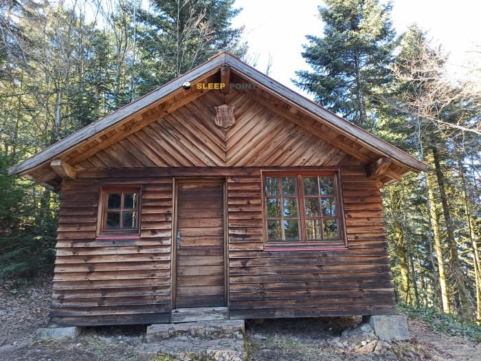
Located in the heart of chalet de bélué, les cherrières, rupt-sur-moselle, Épinal, vosgos, gran este, francia metropolitana, 88360, francia, the Chalet de Bélué refuge offers shelter at 855 meters above sea level. Ideal for trekking and nature lovers, this mountain shelter (Lat: 47.929, Lon: 6.69) is the perfect starting point or resting place for local routes.

See more
See more
Usuario

Lucas Martinez

Premium user

Live weather: Chalet de Bélué

The current weather in Chalet de Bélué indicates a temperature of 11.9°C, although the 18.4 km/h wind makes it feel like 8.7°C. Watch out for gusts of 60.8 km/h. The snow altitude (freezing level 0°) is around 3590 m and today we will reach a high of 15.1°C.
Temperature

11.9°C

Feels like: 8.7°C
Wind

18.4 km/h

Gusts: 60.8 km/h
Freezing level 0°

3590 m

Snow line
Sky & UV

UV 0

Clouds: 91%

Next 48 hours evolution

7-day forecast

04/06
15.1° 10.1°
13.5 mm 26.8 km/h UV máx: 3.85
05:36 21:26
05/06
13.5° 8.3°
2.3 mm 18.7 km/h UV máx: 5.35
05:35 21:27
06/06
15.9° 6.1°
0.3 mm 15.6 km/h UV máx: 7.05
05:35 21:28
07/06
16.9° 9.1°
0 mm 12.2 km/h UV máx: 6.2
05:35 21:29
08/06
20.5°
4.95 mm 10.4 km/h UV máx: 6.8
05:34 21:29
09/06
15.6°
15.9 mm 15.6 km/h UV máx: 5.9
05:34 21:30
10/06
18.2° 6.4°
0 mm 7.9 km/h UV máx: 6.85
05:34 21:31

On a day of liaison through the mountains of Rupt-sur-Moselle , Villa of Bélué fits better as a pass reference than as an isolated destination. Its height, around 855 meters, places it in a half-forest mountain where the orientation depends much on the layout of local tracks, roads and divisives. In this sector of the Vosgos, more of a transition between valleys and loins than of alpine land, it is useful for those who follow long routes or combine full-time tours. The presence of GR 7 , in the great axis that links the Vosgos massif with long routes to the south, it reinforces this role of support in the journey. They also pass through the area trails such as the Sentier des Ducs or the Sentier Gaby Claudel, as well as local circular tours, so that it is appropriate to carry a clear map of the sector and not to rely everything on a single beacon.

Rather than serving as a basis for ascension, this shelter helps to order the march on a ground of closed valleys, soft hills and long transitions through forest. The management of the effort here is to measure access and return well, especially if routes are linked or progress is made with changing weather, common in half-mountain forest areas. There are no immediate sources next to the shelter according to the available data: the nearest one is about 2.7 km away, so it is prudent to leave with sufficient water and basic autonomy. Since there is no precise information about equipment or interior state, it is reasonable to put it as a simple mountain coat within a journey around Rupt-sur-Moselle, not as a point with secure services.

Hiking routes from the refuge

GR 7

Des Vosges aux Pyrénées 01, Ballon d'Alsace - Perrancey-les-Vieux-Moulins

↔ Variable distance
20

Les Étangs du Girmont

↔ 10 km
21

La Beuille, sur la ligne de partage des eaux

↔ 9 km
Local

Le Rosièra

↔ 10 km
Local

Sentier des Ducs

↔ Variable distance
Local

Sentier Gaby Claudel

↔ Variable distance
Local

Circuit du Ménil

↔ Variable distance
Local

Circuit des Hats

↔ Variable distance

Nearby water fountains

Fuente

2.76 Km
Lat: 0 Lon: 0

Fuente

5.25 Km
Lat: 0 Lon: 0

Fuente

5.7 Km
Lat: 0 Lon: 0

Fuente

6.9 Km
Lat: 0 Lon: 0

Fuente

6.94 Km
Lat: 0 Lon: 0

Fuente

7.92 Km
Lat: 0 Lon: 0

Fuente

8.39 Km
Lat: 0 Lon: 0

Fuente

8.78 Km
Lat: 0 Lon: 0
FAQ

Frequently asked questions

Pregunta frecuente
At what exact altitude is the Chalet de Bélué refuge located?
The Chalet de Bélué refuge is located at an altitude of 855 meters above sea level, in the natural surroundings of chalet de bélué, les cherrières, rupt-sur-moselle, Épinal, vosgos, gran este, francia metropolitana, 88360, francia.
Pregunta frecuente
What are the GPS coordinates of the Chalet de Bélué refuge?
To locate the Chalet de Bélué refuge on your GPS or map, use the following coordinates: Latitude 47.929 and Longitude 6.69.
Pregunta frecuente
Is it necessary to carry a GPS to reach the Chalet de Bélué refuge?
It is always highly recommended to carry a GPS device, a route track, or a topographic map in the mountains. You can use the coordinates 47.929, 6.69 to locate this refuge precisely.
More areas

Other areas

Collaborative

Together we improve

image

Send your photos

You can upload photos of shelters and update their status so other users know if they can go there.

Get started
Get started
image

Rate the shelter

Leave your comments to rate the shelter’s condition. In the mountains, we look after each other.

Get started
Get started
image

Add new ones

Did we miss any? Publish the shelters you know so everyone can use them.

Get started
Get started
Download for free from the Apple App Store and Play Store.

Download the app and start looking for the shelter of your next adventure

Aplicación móvil para encontrar refugios de montaña donde dormir
Aplicación móvil para encontrar refugios de montaña donde dormir.
Mapa interactivo de refugios de montaña en los Pirineos dentro de la app
Mapa de refugios de montaña para senderismo y trekking en la app.
Pantalla con información de refugio de montaña con altitud capacidad y servicios
Pantalla con información de refugio de montaña con altitud capacidad y servicios.
Detalles de refugio de montaña con servicios y meteorología en aplicación móvil
Detalles de refugio de montaña con servicios y meteorología en aplicación móvil.
Aplicación para explorar refugios de montaña mediante mapa interactivo
Aplicación para explorar refugios de montaña mediante mapa interactivo.
Ficha completa de refugio de montaña con opiniones y servicios
Ficha completa de refugio de montaña con opiniones y servicios.
Información detallada de refugio en app para montañeros
Información detallada de refugio en app para montañeros.
Listado de refugios de montaña para senderismo y trekking
Listado de refugios de montaña para senderismo y trekking.
Explorar refugios de montaña desde una aplicación móvil
Explorar refugios de montaña desde una aplicación móvil.